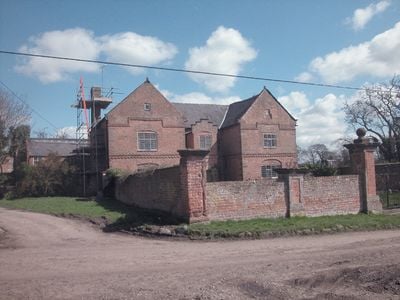
Shotwick Hall, Grade II* listed English country house in Shotwick, England
Shotwick Hall is a brick-built English country house with red sandstone quoins, a Welsh slate roof, and large chimneys arranged in an E-shaped plan across two stories. The property includes a square garden enclosed by brick walls with red sandstone dressings and gate piers positioned at regular intervals around its perimeter.
Joseph Hockenhull commissioned the construction of Shotwick Hall in 1662, replacing an earlier fortified manor house that stood approximately 150 meters to the west. This relocation reflected a shift toward a more open lifestyle, moving away from the need for defensive structures.
The interior staircase features carved balusters and a decorative plaster ceiling with fleur-de-lis and lion designs, reflecting the artistic tastes of its wealthy owners. These ornaments show how educated families displayed their status through fine craftsmanship.
The building and grounds are accessible from the surrounding fields and roads, making orientation straightforward for visitors exploring the property. The walled garden provides clear boundaries, with gate piers serving as helpful reference points when walking around the site.
A moated site marking the original fortified manor house location still exists and measures roughly 25 by 32 meters with raised earthworks. This archaeological remnant sits half a meter above ground level and is surrounded by a moat approximately 10 meters wide, clearly showing where the earlier defensive structure once stood.
Location: Puddington
GPS coordinates: 53.24130,-2.99426
Latest update: December 14, 2025 14:40
RAF Sealand
2.1 km
Shotwick Castle
2 km
Shotwick House
2.7 km
St Michael's Church, Shotwick
284 m
Footpath Guidepost At Junction With Parkgate Road
2.2 km
Gates, gatepiers and churchyard wall along north side of Shotwick Lane
310 m
Front garden walls and gatepiers at Shotwick Hall
20 m
Tombchest of Robert and Martha Ellison, 10 metres southwest of south corner of tower of Church of St Michael
303 m
Manor Farmhouse
220 m
Tombchest of John Nevett Bennett, 5 metres west of south porch of St Michael's Church
301 m
Greyhound Farmhouse
228 m
Footpath Guidepost At Junction Of Pipers Lane Opposite The White House
1.7 km
Sundial in the churchyard of St Michael
307 m
Tombchest of James Phillips, 2 metres south of the sundial in the Churchyard of St Michael
309 m
Granary 30 metres east of Shotwicklodge Farmhouse
1.6 km
Footpath guidepost 50m east of Heath farmhouse
2.4 km
Former kitchen or bakehouse attached to north east corner of Shotwick Hall
19 m
L-shaped ranges of farm buildings 60 metres north of Shotwick Hall
72 m
Tombchest of Rev M Reay and 4 children, 8 metres south of south porch of Church of St Michael
295 m
Tombchest of William Briscoe (died 1723) and others, 4 metres west of priest's door to St Michael's Church
291 m
North Pair of Aircraft Hangars
1.8 km
Barn 70 metres north east of Shotwicklodge Farmhouse
1.5 km
Tombchest of William Briscoe (died 1704) and others, 5 metres southwest of priest's door to St Michael's Church
292 m
Footpath Guidepost 5 Metres North Of Top Lodge
1.5 km
Vicarage Farmhouse
231 m
South Pair of Aircraft Hangars
1.9 km
Gibbet Windmill
2.6 km
Milepost, Parkgate Road, Woodbank
2.2 kmVisited this place? Tap the stars to rate it and share your experience / photos with the community! Try now! You can cancel it anytime.
Discover hidden gems everywhere you go!
From secret cafés to breathtaking viewpoints, skip the crowded tourist spots and find places that match your style. Our app makes it easy with voice search, smart filtering, route optimization, and insider tips from travelers worldwide. Download now for the complete mobile experience.
A unique approach to discovering new places❞
— Le Figaro
All the places worth exploring❞
— France Info
A tailor-made excursion in just a few clicks❞
— 20 Minutes