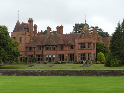
Shotwick House, Grade II listed country house in Saughall, England
The main facade of Shotwick House features seven bays with two polygonal turrets, each topped with pyramidal roofs including lead finials and weather vanes.
Built in 1872 for Horace Dormer Trelawny, Shotwick House underwent reconstruction and expansion in 1907 following a fire under the direction of architect John Douglas.
The architectural design of Shotwick House represents the neo-Elizabethan style with its brick construction, tiled roof, and tall chimneys positioned throughout the structure.
The property requires strict adherence to preservation guidelines due to its Grade II listed status, ensuring the protection of its architectural and historical elements.
The left turret of Shotwick House rises three stories high, distinguishing itself from the right turret and the main two-story structure.
Location: Saughall and Shotwick Park
Architects: John Douglas
GPS coordinates: 53.22560,-2.96310
Latest update: March 12, 2025 21:59
RAF Sealand
2.4 km
Shotwick Castle
883 m
St Michael's Church, Shotwick
2.6 km
All Saints Church, Great Saughall
556 m
St Bartholomew's Church, Sealand
1.5 km
Churchyard boundary wall, Church of St Bartholomew
1.5 km
The Old Swinging Gate Inn
384 m
Bridge Farmhouse
378 m
Gates, gatepiers and churchyard wall along north side of Shotwick Lane
2.6 km
Tombchest of Robert and Martha Ellison, 10 metres southwest of south corner of tower of Church of St Michael
2.6 km
Manor Farmhouse
2.6 km
Tombchest of Rev M Reay and 4 children, 8 metres south of south porch of Church of St Michael
2.6 km
Sundial in the churchyard of St Michael
2.6 km
Greyhound Farmhouse
2.6 km
Tombchest of James Phillips, 2 metres south of the sundial in the Churchyard of St Michael
2.6 km
Tombchest of John Nevett Bennett, 5 metres west of south porch of St Michael's Church
2.6 km
Granary 30 metres east of Shotwicklodge Farmhouse
1.3 km
Tombchest of William Briscoe (died 1723) and others, 4 metres west of priest's door to St Michael's Church
2.6 km
Aldersey House
361 m
Barn 70 metres north east of Shotwicklodge Farmhouse
1.3 km
Tombchest of William Briscoe (died 1704) and others, 5 metres southwest of priest's door to St Michael's Church
2.6 km
Gibbet Windmill
2 km
North Pair of Aircraft Hangars
2.4 km
South Pair of Aircraft Hangars
2.4 km
Vicarage Farmhouse
2.6 km
Footpath guidepost 25 metres south west of Bridge Farmhouse
392 m
Milepost, Saughall Nurseries
1.6 km
Milepost, Parkgate Road, Woodbank
2.3 kmReviews
Visited this place? Tap the stars to rate it and share your experience / photos with the community! Try now! You can cancel it anytime.
Discover hidden gems everywhere you go!
From secret cafés to breathtaking viewpoints, skip the crowded tourist spots and find places that match your style. Our app makes it easy with voice search, smart filtering, route optimization, and insider tips from travelers worldwide. Download now for the complete mobile experience.
A unique approach to discovering new places❞
— Le Figaro
All the places worth exploring❞
— France Info
A tailor-made excursion in just a few clicks❞
— 20 Minutes