Enable Location

We need your location to show you interesting places around you

Discover nearby places

Find interesting locations and hidden gems around you

Precise directions

Get accurate directions and distances to places

Your location is never shared with other users. It's only used when you tap the location button.

Sonning Bridge

Log in to your account

Start exploring — it's free

Trusted by 63,010 travelers worldwide

Continue with Google
Continue with Apple
or

We will send you a code to connect

By continuing, you accept our Terms and Conditions and our Privacy Policy

Check your inbox

We've sent a pincode in your inbox. Please enter the code below.

Discussion Reviews 1 Photos
3.4k Popularity

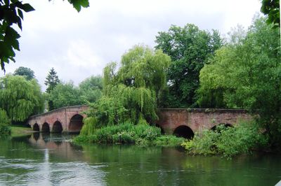
Sonning Bridge, Grade II listed stone bridge in Sonning, England

Sonning Bridge is a single-lane stone arch structure that crosses the River Thames, linking Berkshire on one side with Oxfordshire on the other. The bridge's narrow passage and sturdy masonry design have made it a distinctive feature of the village for centuries.

The bridge was constructed in 1775 to replace an earlier wooden crossing that had served the area for centuries. This stone version became part of wider efforts to improve road connections during the late 1700s.

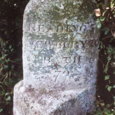
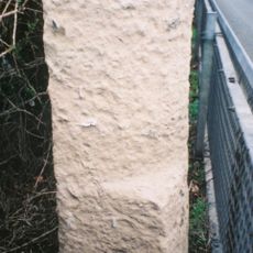
The bridge structure features a central stone marker that indicates the historical boundary between the ancient kingdoms of Wessex and Mercia.

Traffic lights control the flow of vehicles across the narrow passage, as cars can only alternate directions through the single lane. Drivers should be prepared for slow speeds and potential delays, especially during busy periods.

Contemporary artist Impro has transformed the bridge into an art display by installing replicas of everyday objects, including a red post box and telephone.

The community of curious travelers

AroundUs brings together thousands of curated places, local tips, and hidden gems, enriched daily by 60,000 contributors worldwide.

Start exploring
Location
Official opening
1775
Made from material
stone
GPS coordinates
51.47573,-0.91394
Latest update
December 12, 2025 08:00
Around this place
The Deanery
United Kingdom

The Deanery

228 m
Caversham Park
United Kingdom

Caversham Park

3.2 km
The Mill at Sonning
United Kingdom

The Mill at Sonning

128 m
St Andrew's Church, Sonning
United Kingdom

St Andrew's Church, Sonning

190 m
Bull Inn
United Kingdom

Bull Inn

264 m
Palmer Park Stadium
United Kingdom

Palmer Park Stadium

3.1 km
Statue of George Palmer
United Kingdom

Statue of George Palmer

3.2 km
Sonning Lock
United Kingdom

Sonning Lock

479 m
St John the Evangelist Church, Woodley
United Kingdom

St John the Evangelist Church, Woodley

2.4 km
Sonning Backwater Bridges
United Kingdom

Sonning Backwater Bridges

168 m
Phillimore Island
United Kingdom

Phillimore Island

3 km
The Lynch
United Kingdom

The Lynch

2.4 km
Buck Ait
United Kingdom

Buck Ait

1.9 km
Alder Moors
United Kingdom

Alder Moors

2.7 km
Hallsmead Ait
United Kingdom

Hallsmead Ait

2.2 km
Ali's Pond Local Nature Reserve
United Kingdom

Ali's Pond Local Nature Reserve

613 m
Church of St Peter and St Paul, Shiplake
United Kingdom

Church of St Peter and St Paul, Shiplake

2.8 km
United Reformed Church
United Kingdom

United Reformed Church

3 km
Church of St Bartholomew
United Kingdom

Church of St Bartholomew

3.1 km
Milestone, On Grass Verge Back Of Pavement 500 Metres East Of Junction With Sonning Lane
United Kingdom

Milestone, On Grass Verge Back Of Pavement 500 Metres East Of Junction With Sonning Lane

1.1 km
Milestone On Grass Verge,100 Metres East Of Junction With Bath Road
United Kingdom

Milestone On Grass Verge,100 Metres East Of Junction With Bath Road

1.7 km
Railway Bridge And Attached Accommodation Bridge Over River Kennet At SU 7306 7381
United Kingdom

Railway Bridge And Attached Accommodation Bridge Over River Kennet At SU 7306 7381

3.1 km
Milestone At Ngr 7850 7605
United Kingdom

Milestone At Ngr 7850 7605

3 km
Shiplake College, Water Tower Approximately 90 Metres North West
United Kingdom

Shiplake College, Water Tower Approximately 90 Metres North West

2.8 km
Shiplake Rise Farmhouse
United Kingdom

Shiplake Rise Farmhouse

2.7 km
Pump, South End Of Deanery Wall
United Kingdom

Pump, South End Of Deanery Wall

285 m
The Flame by Neil and Auriol Lawson Baker (Reading)
United Kingdom

The Flame by Neil and Auriol Lawson Baker (Reading)

1.5 km
Milestone, London Road; Earley Court, half way up hill near electrical power compound
United Kingdom

Milestone, London Road; Earley Court, half way up hill near electrical power compound

2.2 km
Show the full map
Reviews
Share your experience

No review yet

Discussions
Start a discussion...

No discussion yet

« Sonning Bridge - Grade II listed stone bridge in Sonning, England » is provided by Around Us (aroundus.com). Images and texts are derived from Wikimedia project under a Creative Commons license. You are allowed to copy, distribute, and modify copies of this page, under the conditions set by the license, as long as this note is clearly visible.

Discover hidden gems everywhere you go!

From secret cafés to breathtaking viewpoints, skip the crowded tourist spots and find places that match your style. Our app makes it easy with voice search, smart filtering, route optimization, and insider tips from travelers worldwide. Download now for the complete mobile experience.

Around Us App Screenshot

A unique approach to discovering new places

Le Figaro

All the places worth exploring

France Info

A tailor-made excursion in just a few clicks

20 Minutes

Around Us
Travel Guide & Maps
Download

Send to your phone

QR Code
1

Open the camera app on your mobile.

2

Point at the QR code with your camera. A notification will appear.

3

Tap the notification to open the link.