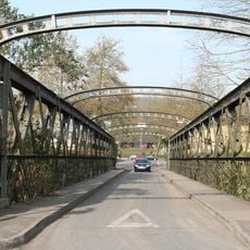
Victoria Bridge, Cable-stayed bridge in Bath, England
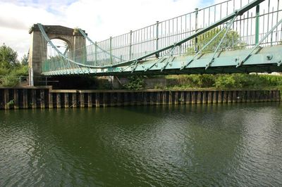
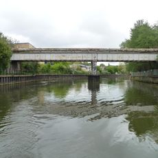
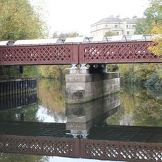
Victoria Bridge is a cable-stayed structure of Bath stone and iron that crosses the River Avon. Its design uses diagonal iron bars in an unusual arrangement to distribute weight across the span.
Built in 1836, it originally served to carry beer across the river and remove the need for ferries. The structure represented an early example of Victorian engineering innovation.
The Grade II* listed structure represents early Victorian engineering, combining traditional bridge design with innovative load-bearing principles through its taper chain system.
The bridge accommodates pedestrians and cyclists crossing between both sides of Bath. It has been well maintained through careful restoration to keep it safe and accessible.
It was originally built to solve a practical brewing problem, making it one of the few bridges designed specifically for industrial cargo. The chain design attracted attention from engineers studying new load-bearing methods.
Location: Bath and North East Somerset
Architects: James Dredge, Sr.
Made from material: Bath Stone, iron
GPS coordinates: 51.38340,-2.37330
Latest update: December 12, 2025 09:03
Royal Victoria Park, Bath
335 m
Midland Bridge
411 m
Norfolk Crescent
250 m
Herschel Museum of Astronomy
453 m
1, 2 and 3 Nile Street and Monmouth Hotel
272 m
1 and 2, Park Cottages
349 m
Cemetery Chapel Of Widcombe, Lyncombe And St James's Cemetery
432 m
Bandstand
374 m
Gasworks Siding Bridge
452 m
Cumberland House
272 m
1, St Ann's Place
378 m
Victoria Gate
306 m
Star Gazers
449 m
8-18 Norfolk Crescent
271 m
Watchman's Box
247 m
2, 3 And 4, St Ann's Place
382 m
1-8, Nelson Place West
230 m
8, St Ann's Place
390 m
9, St Ann's Place
389 m
Destructor Bridge
285 m
Stanier Bridge
336 m
Pair Of Vases Flanking Bandstand
371 m
Victoria Column
291 m
Boundary Wall To St James's Cemetery Including Milestone
352 m
5, 6 And 7, St Ann's Place
394 m
Nos 1 To 12 (Consec) 13, 14 And 15, 16 To 29, 30 To 34 And Attached Railings And Gates
403 m
Destructor Bridge
285 m
Milepost, Lower Bristol Road, W end of St James' Cemetery, opp. Pine way
310 mVisited this place? Tap the stars to rate it and share your experience / photos with the community! Try now! You can cancel it anytime.
Discover hidden gems everywhere you go!
From secret cafés to breathtaking viewpoints, skip the crowded tourist spots and find places that match your style. Our app makes it easy with voice search, smart filtering, route optimization, and insider tips from travelers worldwide. Download now for the complete mobile experience.
A unique approach to discovering new places❞
— Le Figaro
All the places worth exploring❞
— France Info
A tailor-made excursion in just a few clicks❞
— 20 Minutes