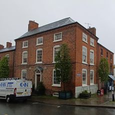
Montgomery Town Hall, Grade II* listed town hall in Montgomery, Wales
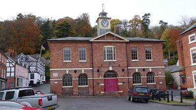
Montgomery Town Hall is a red brick municipal building on Broad Street with two floors, symmetrical sash windows, and a central clock tower. The ground level once served as an open market but now contains enclosed rooms accessed through a wooden paneled doorway at the center of the facade.
A medieval half-timbered building on this site was replaced in 1751 by the current stone structure, designed by William Baker of Audlem under Henry Herbert's direction. The new design reflected changing ideas about public buildings and civic importance during that era.
The upstairs assembly room features a wooden sprung floor that once hosted legal sessions and continues to welcome community events today. This space remains central to how residents gather for town business.
The building sits prominently on Broad Street in the town center and is easy to spot with its distinctive clock tower. Since this is an active municipal building, access to certain areas may be restricted during official sessions or public events.
The clock tower was added in 1921 as a memorial to Alderman Nicholas Watson Fairles-Humphreys, who served as High Sheriff of Montgomeryshire. This later addition became the building's most recognizable feature.
Location: Montgomery
Elevation above the sea: 169.8 m
GPS coordinates: 52.56030,-3.14887
Latest update: December 14, 2025 18:06
Montgomery Castle
346 m
Hen Domen
1.8 km
Lymore, Montgomery
997 m
The Old Bell
41 m
Ffridd Faldwyn, Montgomery
721 m
Montgomeryshire County War Memorial
957 m
Caerhowel Bridge
3.1 km
St Nicholas's Church
166 m
Church of St Michael
4.4 km
The Dragon Hotel
41 m
Bridge 131 Over The Montgomeryshire Canal, Garthmyl
3.8 km
Chirbury War Memorial
4.4 km
Glansevern Hall
4.4 km
Montgomery Library
74 m
Milestone at NGR SO 2463 9319
4.1 km
Colomendy
26 m
Tan-y-castell
33 m
Broad Street Farmhouse
39 m
Motte and bailey castle and line of Offa's Dyke adjacent to Brompton Mill
4.4 km
Milestone near junction with New Road
742 m
The Old Rectory
2.9 km
Fron Footbridge
4 km
Mellington Gatehouse
4.6 km
Milestone At Ngr So 2410 9777
2.3 km
Milestone At Ngr So 2448 9376
3.7 km
Group Of 10 Chest Tombs Approximately 3.5 To 10 Metres South Of Chancel Of Church Of St Michael
4.4 km
Offa's Dyke: section 2/3 mile (1170m) long, N from southern boundary of Rownal Covert
2.2 km
Milestone, St Michaels Church, Chirbury
4.4 kmVisited this place? Tap the stars to rate it and share your experience / photos with the community! Try now! You can cancel it anytime.
Discover hidden gems everywhere you go!
From secret cafés to breathtaking viewpoints, skip the crowded tourist spots and find places that match your style. Our app makes it easy with voice search, smart filtering, route optimization, and insider tips from travelers worldwide. Download now for the complete mobile experience.
A unique approach to discovering new places❞
— Le Figaro
All the places worth exploring❞
— France Info
A tailor-made excursion in just a few clicks❞
— 20 Minutes