Enable Location

We need your location to show you interesting places around you

Discover nearby places

Find interesting locations and hidden gems around you

Precise directions

Get accurate directions and distances to places

Your location is never shared with other users. It's only used when you tap the location button.

Clegyr Boia

Log in to your account

Start exploring — it's free

Trusted by 62,857 travelers worldwide

Continue with Google
Continue with Apple
or

We will send you a code to connect

By continuing, you accept our Terms and Conditions and our Privacy Policy

Check your inbox

We've sent a pincode in your inbox. Please enter the code below.

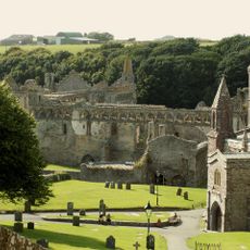
Clegyr Boia, Prehistoric archaeological site near St Davids, Wales.

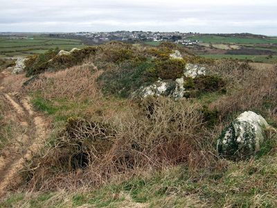
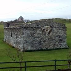
Clegyr Boia is an archaeological site featuring twin rocky outcrops that rise about 65 feet above the surrounding farmland. The hillsides contain remains of ancient settlements and defensive structures built over many centuries.

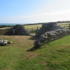
Excavations in 1902 and 1943 revealed evidence of Neolithic settlements dating back about 5500 years with both rectangular and circular dwellings. The location later served as a fortress for an Irish chieftain and remained a significant place in the region.

The name comes from a 6th-century Irish chieftain called Boia who built a stronghold here. Visitors walking the site can still see traces of this early settlement scattered across the rocky terrain.

The site sits roughly 2 kilometers west of St Davids and is reached by walking paths that cross through farmland. The rocky terrain requires sturdy footwear and careful footing on uneven ground.

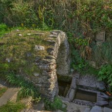
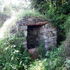
Near the southern base of the rocky outcrops sits a small pool called Ffynnon Lygaid that holds special meaning for local people. This modest waterhole has been valued by residents for generations.

The community of curious travelers

AroundUs brings together thousands of curated places, local tips, and hidden gems, enriched daily by 60,000 contributors worldwide.

Start exploring
Location
GPS coordinates
51.87850,-5.28850
Latest update
December 14, 2025 16:41
Around this place
St Davids Cathedral
United Kingdom

St Davids Cathedral

1.5 km
Whitesands Bay
United Kingdom

Whitesands Bay

1.8 km
Chapel of St Non
United Kingdom

Chapel of St Non

1.5 km
St Davids Bishops Palace
United Kingdom

St Davids Bishops Palace

1.3 km
Porthclais
United Kingdom

Porthclais

1.3 km
Porth-y-Tŵr
United Kingdom

Porth-y-Tŵr

1.5 km
Ruins of St. Justinian's Chapel, Porthstinian
United Kingdom

Ruins of St. Justinian's Chapel, Porthstinian

1.4 km
Ebeneser Welsh Independent Chapel
United Kingdom

Ebeneser Welsh Independent Chapel

1.6 km
Chapel of Our Lady & St. Non
United Kingdom

Chapel of Our Lady & St. Non

1.6 km
Tabernacl Chapel
United Kingdom

Tabernacl Chapel

1.5 km
St Non's Well
United Kingdom

St Non's Well

1.5 km
Oriel y Parc
United Kingdom

Oriel y Parc

1.9 km
Former Church School,Quickwell Hill
United Kingdom

Former Church School,Quickwell Hill

1.6 km
Penporthclais
United Kingdom

Penporthclais

1.1 km
St. David's Cathedral Hall (formerly Chapel Of St.mary's College) & Attached Cloister Ruins,the Cathe
United Kingdom

St. David's Cathedral Hall (formerly Chapel Of St.mary's College) & Attached Cloister Ruins,the Cathe

1.4 km
St Davids Library
United Kingdom

St Davids Library

1.5 km
The City Cross,cross Square (in Centre)
United Kingdom

The City Cross,cross Square (in Centre)

1.6 km
Menai,Including Garden Walls,Gates & Railings, Cross Square
United Kingdom

Menai,Including Garden Walls,Gates & Railings, Cross Square

1.6 km
Lifeboat House, St. Justinian's
United Kingdom

Lifeboat House, St. Justinian's

1.4 km
Old Lifeboat House, Porthstinian/St. Justinian's
United Kingdom

Old Lifeboat House, Porthstinian/St. Justinian's

1.4 km
Well-Head opposite Rhosson Farm
United Kingdom

Well-Head opposite Rhosson Farm

891 m
Pont Y Penyd,The Cathedral Close
United Kingdom

Pont Y Penyd,The Cathedral Close

1.5 km
Brecon House
United Kingdom

Brecon House

1.4 km
Outbuilding Range On S.Side of Farmyard at Rhosson Ganol,Rhosson
United Kingdom

Outbuilding Range On S.Side of Farmyard at Rhosson Ganol,Rhosson

915 m
Rhosson Uchaf/Rhosson Farmhouse
United Kingdom

Rhosson Uchaf/Rhosson Farmhouse

840 m
Nos.22 & 23 Cross Square (Cartref Restaurant)
United Kingdom

Nos.22 & 23 Cross Square (Cartref Restaurant)

1.6 km
Bethel Chapel
United Kingdom

Bethel Chapel

799 m
The Close Wall (formerly Listed With Porth Y Twr) The Cathedral Close
United Kingdom

The Close Wall (formerly Listed With Porth Y Twr) The Cathedral Close

1.4 km
Show the full map
« Clegyr Boia - Prehistoric archaeological site near St Davids, Wales » is provided by Around Us (aroundus.com). Images and texts are derived from Wikimedia project under a Creative Commons license. You are allowed to copy, distribute, and modify copies of this page, under the conditions set by the license, as long as this note is clearly visible.

Discover hidden gems everywhere you go!

From secret cafés to breathtaking viewpoints, skip the crowded tourist spots and find places that match your style. Our app makes it easy with voice search, smart filtering, route optimization, and insider tips from travelers worldwide. Download now for the complete mobile experience.

Around Us App Screenshot

A unique approach to discovering new places

Le Figaro

All the places worth exploring

France Info

A tailor-made excursion in just a few clicks

20 Minutes

Around Us
Travel Guide & Maps
Download

Send to your phone

QR Code
1

Open the camera app on your mobile.

2

Point at the QR code with your camera. A notification will appear.

3

Tap the notification to open the link.