Rickmansworth Aquadrome

Log in to your account

AroundUs is a community-driven map of interesting places, built by curious explorers like you. It grows with every review, story, and photo you share.
Connect to save your favorite spots, contribute locations, and create personalized routes.
Continue with Google
Continue with Apple
Continue with X
Continue with Facebook
Continue with email
By continuing, you accept our Terms and Conditions and our Privacy Policy
Create an account

Rickmansworth Aquadrome

Add to collection
Map
Suggest a change
Share

Rickmansworth Aquadrome, Nature reserve and park in Rickmansworth, England

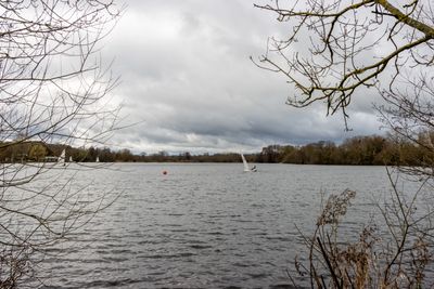
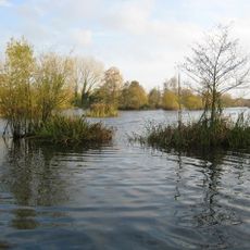
Rickmansworth Aquadrome is a 41-hectare nature reserve featuring two lakes, extensive woodlands of oak and willow trees, and open grasslands connected by maintained pathways. The site includes walking routes that guide visitors around the water and through the surrounding green spaces.

The lakes were created from gravel extraction that once supplied building materials for London-area construction projects. The former quarry site was eventually transformed into the nature reserve and recreation area it is today.

The Café in the Park serves as a gathering place where locals meet throughout the year for meals and community events. Residents use the lakes and grasslands for recreation, making it a hub for people who enjoy spending time outdoors.

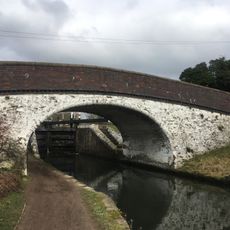
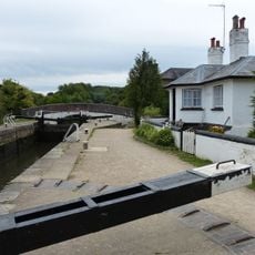
Multiple walking routes are available, including a 1.5-mile (2.4 km) trail around the lakes and along the Grand Union Canal with parking facilities nearby. The terrain is relatively flat and straightforward to navigate, making it accessible for different ability levels.

The site is home to a diverse bird population including resident herons, moorhens, and various waterfowl species that thrive in the protected wetland. Birdwatchers often spot these species throughout the seasons.

Location: Rickmansworth

Location: Three Rivers

GPS coordinates: 51.63310,-0.47850

Latest update: December 10, 2025 20:01

Photos
Around this place
Stockers Lake
United Kingdom

Stockers Lake

742 m
War Memorial About 40 Metres East of Church of St Mary
United Kingdom

War Memorial About 40 Metres East of Church of St Mary

885 m
Church of St Mary, Rickmansworth
United Kingdom

Church of St Mary, Rickmansworth

843 m
K6 Telephone Kiosk Outside St Mary's Church
United Kingdom

K6 Telephone Kiosk Outside St Mary's Church

865 m
7 and 9, Church Street
United Kingdom

7 and 9, Church Street

887 m
25 and 27, Church Street
United Kingdom

25 and 27, Church Street

859 m
99, Church Street
United Kingdom

99, Church Street

824 m
29 and 31, Church Street
United Kingdom

29 and 31, Church Street

833 m
53-61, Church Street
United Kingdom

53-61, Church Street

903 m
The Fox And Hounds Public House
United Kingdom

The Fox And Hounds Public House

761 m
The Feathers Public House
United Kingdom

The Feathers Public House

827 m
Wilson Monument Immediately North Of Chancel Of Church Of St Mary
United Kingdom

Wilson Monument Immediately North Of Chancel Of Church Of St Mary

859 m
London Coal Duty Marker On Towing Path About 10 Metres South East Of Stocker's House
United Kingdom

London Coal Duty Marker On Towing Path About 10 Metres South East Of Stocker's House

411 m
Stockers Lock House
United Kingdom

Stockers Lock House

379 m
Bridge Number 175 At Stocker's Lock
United Kingdom

Bridge Number 175 At Stocker's Lock

404 m
The Chequers Restaurant
United Kingdom

The Chequers Restaurant

861 m
The Old Vicarage
United Kingdom

The Old Vicarage

858 m
Stockers House
United Kingdom

Stockers House

411 m
Mile Post On Towing Path About 600 Metres North East Of Stocker's Lock
United Kingdom

Mile Post On Towing Path About 600 Metres North East Of Stocker's Lock

337 m
The Priory
United Kingdom

The Priory

824 m
Pair Of Chest Tombs With Fluted Corner Piers About 10 Metres North Of Church Of St Mary
United Kingdom

Pair Of Chest Tombs With Fluted Corner Piers About 10 Metres North Of Church Of St Mary

837 m
The Bury
United Kingdom

The Bury

741 m
72, 72A And 72B, High Street
United Kingdom

72, 72A And 72B, High Street

878 m
21 And 25, Harefield Road
United Kingdom

21 And 25, Harefield Road

684 m
142 And 144, High Street
United Kingdom

142 And 144, High Street

791 m
Barn About 25 Metres North West Of Stocker's Farm House
United Kingdom

Barn About 25 Metres North West Of Stocker's Farm House

495 m
Barn And Cart Shed About 35 Metres North North West Of Stocker's Farm House
United Kingdom

Barn And Cart Shed About 35 Metres North North West Of Stocker's Farm House

466 m
Stockers Lock Number 82
United Kingdom

Stockers Lock Number 82

380 m
Show the full map
Reviews

Visited this place? Tap the stars to rate it and share your experience / photos with the community! Try now! You can cancel it anytime.

« Rickmansworth Aquadrome - Nature reserve and park in Rickmansworth, England » is provided by Around Us (aroundus.com). Images and texts are derived from Wikimedia project under a Creative Commons license. You are allowed to copy, distribute, and modify copies of this page, under the conditions set by the license, as long as this note is clearly visible.

Discover hidden gems everywhere you go!

From secret cafés to breathtaking viewpoints, skip the crowded tourist spots and find places that match your style. Our app makes it easy with voice search, smart filtering, route optimization, and insider tips from travelers worldwide. Download now for the complete mobile experience.

Around Us App Screenshot

A unique approach to discovering new places

Le Figaro

All the places worth exploring

France Info

A tailor-made excursion in just a few clicks

20 Minutes