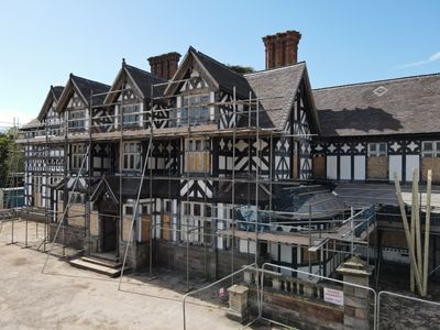
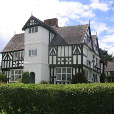
Seighford Hall, Grade II listed house in Seighford, England
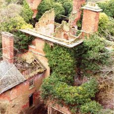
Seighford Hall is a two-storey brick building with timber framing and irregular proportions, featuring nine mullioned windows and tiled roofs across its front. Three distinctive gables topped with carved boards and a cupola above the main roof define its roofline.
Built in the late 1500s, the hall underwent major changes during the 1700s when new windows and chimneys were added. These updates reflect how people's tastes and needs shifted across the centuries.
The interior holds woodwork and a staircase from the 17th and 18th centuries that show how craftspeople of that time built and decorated homes. Walking through, you can see the care put into details like paneling and joinery.
The building's Grade II listed status means any work on its structure or exterior needs special approval from authorities. This protection ensures the building keeps its historic character for future visitors to see.
The roof displays an unusual asymmetrical design with three gables and a central cupola that create an off-balance look. This type of composition was less common in residential buildings of that era and stands out to anyone passing by.
Location: Seighford
GPS coordinates: 52.82717,-2.18473
Latest update: December 14, 2025 14:26
Stafford Castle
4.1 km
Broad Eye Windmill
4.7 km
Doxey Marshes
3.4 km
Abbey House
4 km
Berry Ring hillfort
4.5 km
Church of All Saints
2.5 km
Church of St Mary
3.7 km
Church of St Chad
805 m
Creswell Chapel
2 km
Church of All Saints
3.5 km
Church of St Mary
4.5 km
Staffordshire County War Memorial With Flanking Walls And Gates
4.9 km
Clanford Hall
1.2 km
Milepost Stafford Newport Road 4 Miles From Stafford
974 m
Milepost Stafford Newport Road 6 Miles From Stafford
3 km
Milepost Stafford Newport Road 7 Miles From Stafford
4.5 km
Milepost Stafford Newport Road 5 Miles From Stafford
1.6 km
Friends' Meeting House
4.7 km
Milepost North Of Layby, Near Stafford Bypass
3.5 km
Milestone, between Little Bridgeford & Cresswell
1.8 km
Milestone, Trinity Fields, Stone Road, N of layby, N of Stafford by-pass
3.5 km
Milepost, Cresswell Grove
2.4 km
Milepost, Little Bridgeford
1.9 km
Milepost, Newport Road, E of West Way and W of Stafford town centre
4.8 km
Milepost, between Little Bridgeford & Cresswell
1.8 km
Milepost, Walton
2.8 km
Milestone, Walton (replaced by cast iron MS)
2.8 km
Milepost, E of Four Lane Ends
4.1 kmVisited this place? Tap the stars to rate it and share your experience / photos with the community! Try now! You can cancel it anytime.
Discover hidden gems everywhere you go!
From secret cafés to breathtaking viewpoints, skip the crowded tourist spots and find places that match your style. Our app makes it easy with voice search, smart filtering, route optimization, and insider tips from travelers worldwide. Download now for the complete mobile experience.
A unique approach to discovering new places❞
— Le Figaro
All the places worth exploring❞
— France Info
A tailor-made excursion in just a few clicks❞
— 20 Minutes