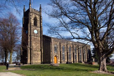
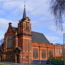
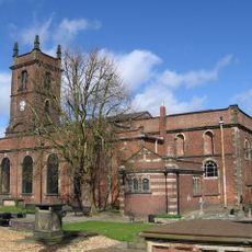
Church of St Andrew, Anglican parish church in Netherton, United Kingdom
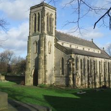
The Church of St Andrew is an Anglican parish church in Netherton with a distinctive west tower featuring bell openings and pointed arch windows. The structure is faced with Gornal stone ashlar and stands prominently at the highest point of Netherton Hill.
The church was built between 1827 and 1830 under architect Thomas Lee's design as a Commissioners' Church with public funding. This construction responded to the need for worship space in the rapidly expanding industrial area of Netherton.
The church serves as a gathering place where the local community comes together for regular worship and musical performances throughout the year. Visitors can experience the ongoing role this place plays in people's daily religious and social lives.
The church is situated at the summit of Netherton Hill making it visible from various approaches. While on-site parking is limited, visitors can find additional parking on surrounding streets without difficulty.
The churchyard contains unmarked graves of people who died during cholera epidemics that swept through Dudley in 1831 and 1832. These silent graves reflect a difficult chapter in the health history of this growing industrial community.
Location: Dudley
GPS coordinates: 52.49076,-2.09240
Latest update: December 14, 2025 14:41
Round Oak Steelworks
1.6 km
Delph Locks
2.5 km
Dudley Museum and Art Gallery
2.4 km
Netherton Reservoir
697 m
Cradley Heath Baptist Church
2.2 km
Church of St. Thomas and St Luke, Dudley
2 km
Cobb's Engine House
1.6 km
Parkhead Viaduct
1 km
Saltwells Local Nature Reserve
944 m
St John's Church, Dudley
2.4 km
Bumble Hole Local Nature Reserve
1.4 km
Council House
2.4 km
Warren's Hall Country Park
1.8 km
Church of St. Edmund, Dudley
2.5 km
Doulton's Claypit
1.1 km
Majestic Cinema, Cradley Heath
2.3 km
Church of the Holy Trinity
2.5 km
Church of St James the Great
2.5 km
Dudley Library
2.4 km
Odeon Dudley (Merry Hill)
2 km
Cradley Heath Library
2.1 km
Towpath Bridge, Approximately 300 Metres North West Of Highbridge Road
500 m
Provision House
2.1 km
South Portal, Netherton Tunnel, Warrens Hill Park Birmingham Canal Netherton Tunnel Branch Windmill End, Rowley Kings
1.6 km
Footbridge over Netherton Tunnel Branch at Windmill End
1.5 km
James Forsyth Drinking Fountain
2.3 km
Pensnett War Memorial
2.5 km
Grange Park
2.3 kmVisited this place? Tap the stars to rate it and share your experience / photos with the community! Try now! You can cancel it anytime.
Discover hidden gems everywhere you go!
From secret cafés to breathtaking viewpoints, skip the crowded tourist spots and find places that match your style. Our app makes it easy with voice search, smart filtering, route optimization, and insider tips from travelers worldwide. Download now for the complete mobile experience.
A unique approach to discovering new places❞
— Le Figaro
All the places worth exploring❞
— France Info
A tailor-made excursion in just a few clicks❞
— 20 Minutes