Enable Location

We need your location to show you interesting places around you

Discover nearby places

Find interesting locations and hidden gems around you

Precise directions

Get accurate directions and distances to places

Your location is never shared with other users. It's only used when you tap the location button.

Cow Ark Farmhouse

Log in to your account

Start exploring — it's free

Trusted by 62,429 travelers worldwide

Continue with Google
Continue with Apple
or

We will send you a code to connect

By continuing, you accept our Terms and Conditions and our Privacy Policy

Check your inbox

We've sent a pincode in your inbox. Please enter the code below.

Cow Ark Farmhouse

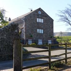
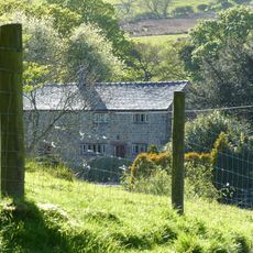
Cow Ark Farmhouse, Grade II listed farmhouse in Bowland Forest Low, Ribble Valley, Lancashire, UK

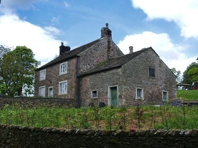
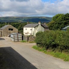
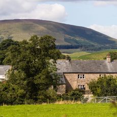
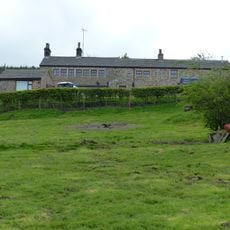
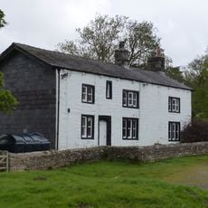
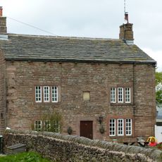
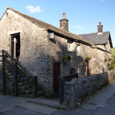
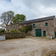
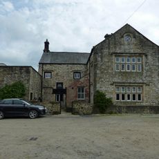
Cow Ark Farmhouse is a two-story sandstone building from around 1780 located in Bowland Forest Low. The house features small mullioned windows and a slate roof, with two distinct sections creating a practical layout typical of working farms from that period.

The building was constructed around 1780 when farming was the backbone of rural Lancashire life. Its Grade II listing in 1984 recognized its historical importance and ensured legal protection for future preservation.

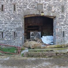
The name Cow Ark hints at the farm's past use for keeping livestock, a naming pattern common among rural properties in the area. This reflects how the building and its surrounding land were woven into the fabric of agricultural life for generations.

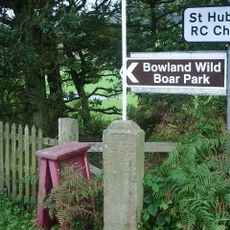
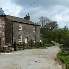
The building remains private property and can only be viewed from outside, so plan for a leisurely walk around the structure to observe its details. The rural setting surrounded by fields and woodland makes it easy to appreciate the architecture and take in the surrounding landscape.

The building showcases practical craftsmanship from the late 1700s using locally sourced materials deliberately chosen to keep the structure warm and weather-resistant. This thoughtful construction with sandstone walls and slate roof reveals how past generations engineered durability into their homes.

The community of curious travelers

AroundUs brings together thousands of curated places, local tips, and hidden gems, enriched daily by 60,000 contributors worldwide.

Start exploring
GPS coordinates
53.90381,-2.49969
Latest update
February 9, 2026 07:42
Around this place
Browsholme Hall
United Kingdom

Browsholme Hall

1.2 km
Longridge Fell
United Kingdom

Longridge Fell

4.6 km
The Inn at Whitewell
United Kingdom

The Inn at Whitewell

2 km
Lower Lees Farmhouse
United Kingdom

Lower Lees Farmhouse

2.1 km
Higher Lees Farmhouse
United Kingdom

Higher Lees Farmhouse

1 km
Church of St Michael
United Kingdom

Church of St Michael

2 km
Giddy Bridge
United Kingdom

Giddy Bridge

4.1 km
Burholme Bridge
United Kingdom

Burholme Bridge

2.9 km
Loud Mytham Bridge
United Kingdom

Loud Mytham Bridge

3.3 km
Guidestone, ExYW Lees, E of River Hodder, in wall
United Kingdom

Guidestone, ExYW Lees, E of River Hodder, in wall

1.6 km
Farm building at Fair Oak Farm 400 metres north-west of Fair Oak Farmhouse
United Kingdom

Farm building at Fair Oak Farm 400 metres north-west of Fair Oak Farmhouse

2.6 km
Crimpton Farmhouse
United Kingdom

Crimpton Farmhouse

1.9 km
Milestone at SD 657 499, approximately 150 metres south east of school
United Kingdom

Milestone at SD 657 499, approximately 150 metres south east of school

4.8 km
Burholme Farmhouse
United Kingdom

Burholme Farmhouse

3.3 km
Marl Hill Farmhouse
United Kingdom

Marl Hill Farmhouse

2.3 km
Farm store to south-east of southern farmhouse
United Kingdom

Farm store to south-east of southern farmhouse

3.6 km
West Lodge, Browsholme Hall and pair of gatepiers adjoining to south
United Kingdom

West Lodge, Browsholme Hall and pair of gatepiers adjoining to south

1 km
Higher Whitewell Farmhouse
United Kingdom

Higher Whitewell Farmhouse

2.3 km
Southern Farmhouse
United Kingdom

Southern Farmhouse

3.6 km
New Laund Farmhouse
United Kingdom

New Laund Farmhouse

2.4 km
Barn at Fair Oak Farm
United Kingdom

Barn at Fair Oak Farm

2.5 km
Limekiln 20 metres north of Cow Ark Bridge
United Kingdom

Limekiln 20 metres north of Cow Ark Bridge

60 m
Doeford Bridge
United Kingdom

Doeford Bridge

3.2 km
Lower Birkett Farmhouse
United Kingdom

Lower Birkett Farmhouse

3.9 km
Higher Birkett Farmhouse and buildings adjoining to the east
United Kingdom

Higher Birkett Farmhouse and buildings adjoining to the east

3.8 km
Browsholme Spire, adjoining south west end of Spire Farmhouse
United Kingdom

Browsholme Spire, adjoining south west end of Spire Farmhouse

1.5 km
Stakes
United Kingdom

Stakes

3.1 km
Guidestone, ExYW Lees, E of River Hodder, behind modern road sign
United Kingdom

Guidestone, ExYW Lees, E of River Hodder, behind modern road sign

1.6 km
Show the full map
« Cow Ark Farmhouse - Grade II listed farmhouse in Bowland Forest Low, Ribble Valley, Lancashire, UK » is provided by Around Us (aroundus.com). Images and texts are derived from Wikimedia project under a Creative Commons license. You are allowed to copy, distribute, and modify copies of this page, under the conditions set by the license, as long as this note is clearly visible.

Discover hidden gems everywhere you go!

From secret cafés to breathtaking viewpoints, skip the crowded tourist spots and find places that match your style. Our app makes it easy with voice search, smart filtering, route optimization, and insider tips from travelers worldwide. Download now for the complete mobile experience.

Around Us App Screenshot

A unique approach to discovering new places

Le Figaro

All the places worth exploring

France Info

A tailor-made excursion in just a few clicks

20 Minutes

Around Us
Travel Guide & Maps
Download

Send to your phone

QR Code
1

Open the camera app on your mobile.

2

Point at the QR code with your camera. A notification will appear.

3

Tap the notification to open the link.