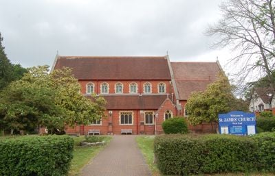
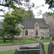
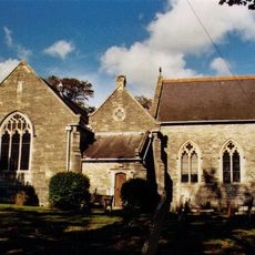
Church of St James, Anglican church in West End, England
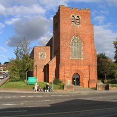
Church of St James is an Anglican church building in West End constructed from red brick and positioned on a hillside. The structure displays traditional ecclesiastical features including iron gutters, lead ridging, and rainwater pipes.
The current building was constructed in 1890 by architect Sir Arthur Blomfield, drawing on 15th-century gothic style. The original church on the site dated from 1836 before being replaced by this later structure.
The church serves as a gathering place for the local community, hosting regular Anglican services and various events throughout the year. People visit for worship, quiet reflection, and to participate in the life of their neighborhood.
The church sits on an elevated position accessible from the main street, offering good visibility and clear sightlines from surrounding areas. Visiting hours follow the religious services schedule, so it helps to check when services are held before planning a visit.
The original church tower once had a brick spire that was struck by lightning in 1875 and subsequently removed. A small hipped roof was installed to replace it, a modification that remains visible to this day.
Location: West End
Website: http://stjameswestend.org.uk
GPS coordinates: 50.92458,-1.33838
Latest update: December 14, 2025 11:21
South Stoneham House
3 km
Wessex Lane Halls
3 km
Northam Bridge
3.5 km
Itchen Valley Country Park
2.1 km
Townhill Park House
1.7 km
Cobden Bridge
2.8 km
St. Mary's Church, South Stoneham
2.9 km
Chessel Bay
3 km
St Denys Priory
3 km
Bitterne Manor
3.3 km
Church of Ascension
2.5 km
Church of St Mary
3.1 km
Church of St Denys
3.1 km
Church of the Holy Saviour
1.8 km
Jesus Chapel - St Mary Extra
3.4 km
The Fleming Arms Public House
3.2 km
Mans Bridge
2.4 km
Hedge End Library
2.6 km
Clock Tower (At East End Of Cobden Bridge)
2.6 km
Bitterne Library
1.6 km
Cobbett Road Library
2.6 km
West End War Memorial, Hampshire
507 m
Hedge End War Memorial
2.7 km
Milestone, Hatch Grange
465 m
Milestone, Wide Lane, Swaythling; 50m W roundabout/jcn Mansbridge Road
3.2 km
Milestone, Thornhill Park; by Abbots Leigh, Upper Northam Drive, opposite the allotments
1.6 km
Milestone, Bitterne; opp. 292 Bitterne Road West. 50m W junction with Juniper Road
2.4 km
Milestone, Wildern, Botleigh Grange; opp. No. 25, Grange Road
2.9 kmVisited this place? Tap the stars to rate it and share your experience / photos with the community! Try now! You can cancel it anytime.
Discover hidden gems everywhere you go!
From secret cafés to breathtaking viewpoints, skip the crowded tourist spots and find places that match your style. Our app makes it easy with voice search, smart filtering, route optimization, and insider tips from travelers worldwide. Download now for the complete mobile experience.
A unique approach to discovering new places❞
— Le Figaro
All the places worth exploring❞
— France Info
A tailor-made excursion in just a few clicks❞
— 20 Minutes