Enable Location

We need your location to show you interesting places around you

Discover nearby places

Find interesting locations and hidden gems around you

Precise directions

Get accurate directions and distances to places

Your location is never shared with other users. It's only used when you tap the location button.

Easton Jamia Mosque

Log in to your account

Start exploring — it's free

Trusted by 62,127 travelers worldwide

Continue with Google
Continue with Apple
or

We will send you a code to connect

By continuing, you accept our Terms and Conditions and our Privacy Policy

Check your inbox

We've sent a pincode in your inbox. Please enter the code below.

Easton Jamia Mosque

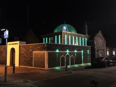
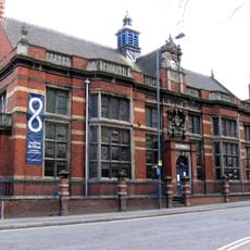
Easton Jamia Mosque, Islamic worship center in Easton, Bristol, England

Easton Jamia Mosque is an Islamic worship center in Easton, Bristol, featuring a transparent dome that glows with green light at night to mark the skyline. The building contains separate prayer spaces for 400 men and 200 women, along with teaching rooms and community spaces for gatherings.

The building originally opened as St Mark's Road National School in 1855 before being converted to a mosque in 1983. Major restoration work took place in 2017 to update the facilities.

The mosque functions as a community hub bringing together worshippers from multiple backgrounds and creating a shared space for connection. Visitors can observe how the building serves both spiritual and social purposes for the neighborhood.

The space is organized with separate entrances and prayer areas for men and women, making navigation straightforward for visitors. It helps to know the layout when planning your visit, as different sections serve different functions.

The building transitioned from serving as a school to its current role, a transformation that shaped its architecture and interior layout. This change reflects how communities evolve and how spaces are repurposed to meet new needs.

The community of curious travelers

AroundUs brings together thousands of curated places, local tips, and hidden gems, enriched daily by 60,000 contributors worldwide.

Start exploring
Location
Inception
2017
GPS coordinates
51.46729,-2.56451
Latest update
December 14, 2025 14:40
Around this place
Trinity Centre
United Kingdom

Trinity Centre

1.3 km
St Paul's Church, Bristol
United Kingdom

St Paul's Church, Bristol

1.6 km
St Werburgh's Church, Bristol
United Kingdom

St Werburgh's Church, Bristol

960 m
Palace Hotel, Bristol
United Kingdom

Palace Hotel, Bristol

1.6 km
St George Park
United Kingdom

St George Park

1.3 km
Eastville Park
United Kingdom

Eastville Park

1 km
St Peter and St Paul, Bristol
United Kingdom

St Peter and St Paul, Bristol

612 m
Tollgate House
United Kingdom

Tollgate House

1.6 km
Trinity Road Library
United Kingdom

Trinity Road Library

1.3 km
Montpelier
United Kingdom

Montpelier

1.6 km
Church of St Jude the Apostle with St Matthias on the Weir
United Kingdom

Church of St Jude the Apostle with St Matthias on the Weir

1.5 km
Church of St Ambrose
United Kingdom

Church of St Ambrose

1.1 km
Church of St Agnes with St Simon
United Kingdom

Church of St Agnes with St Simon

984 m
Greenbank Cemetery Pair Of Attached Mortuary Chapels
United Kingdom

Greenbank Cemetery Pair Of Attached Mortuary Chapels

781 m
The Phoenix Public House
United Kingdom

The Phoenix Public House

1.6 km
Brunel House Muller Homes (City Of Bristol College)
United Kingdom

Brunel House Muller Homes (City Of Bristol College)

1.7 km
Entrance Gates And Piers To Greenbank Cemetery And Railings To East
United Kingdom

Entrance Gates And Piers To Greenbank Cemetery And Railings To East

731 m
Two Pillars
United Kingdom

Two Pillars

1.3 km
St George Library
United Kingdom

St George Library

1.6 km
Junction 3 Library
United Kingdom

Junction 3 Library

622 m
7-13 Portland Square
United Kingdom

7-13 Portland Square

1.6 km
31-34 Portland Square
United Kingdom

31-34 Portland Square

1.7 km
22-28 Portland Square
United Kingdom

22-28 Portland Square

1.6 km
New Street Flats (Former Quaker Workhouse)
United Kingdom

New Street Flats (Former Quaker Workhouse)

1.6 km
Milestone At St 6127 7590, Approximately 40 Metres North East Of South Entrance To Purdown Hospital
United Kingdom

Milestone At St 6127 7590, Approximately 40 Metres North East Of South Entrance To Purdown Hospital

1.5 km
Numbers 14-17 And Attached Area Railings
United Kingdom

Numbers 14-17 And Attached Area Railings

1.6 km
Numbers 1 To 6 And Attached Area Railings
United Kingdom

Numbers 1 To 6 And Attached Area Railings

1.7 km
Milestone, Fishponds Road, jct with Oakdene Avenue
United Kingdom

Milestone, Fishponds Road, jct with Oakdene Avenue

1.3 km
Show the full map
« Easton Jamia Mosque - Islamic worship center in Easton, Bristol, England » is provided by Around Us (aroundus.com). Images and texts are derived from Wikimedia project under a Creative Commons license. You are allowed to copy, distribute, and modify copies of this page, under the conditions set by the license, as long as this note is clearly visible.

Discover hidden gems everywhere you go!

From secret cafés to breathtaking viewpoints, skip the crowded tourist spots and find places that match your style. Our app makes it easy with voice search, smart filtering, route optimization, and insider tips from travelers worldwide. Download now for the complete mobile experience.

Around Us App Screenshot

A unique approach to discovering new places

Le Figaro

All the places worth exploring

France Info

A tailor-made excursion in just a few clicks

20 Minutes

Around Us
Travel Guide & Maps
Download

Send to your phone

QR Code
1

Open the camera app on your mobile.

2

Point at the QR code with your camera. A notification will appear.

3

Tap the notification to open the link.