Archway Hospital

Log in to your account

AroundUs is a community-driven map of interesting places, built by curious explorers like you. It grows with every review, story, and photo you share.
Connect to save your favorite spots, contribute locations, and create personalized routes.
Continue with Google
Continue with Apple
Continue with X
Continue with Facebook
Continue with email
By continuing, you accept our Terms and Conditions and our Privacy Policy
Create an account
Add to collection
Map
Suggest a change
Share

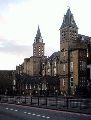
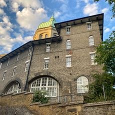
Archway Hospital, Hospital building in Highgate, England

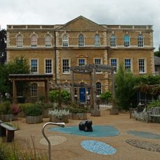
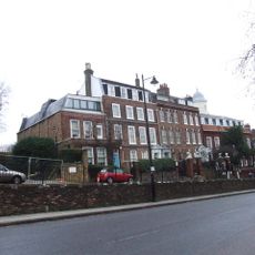
Archway Hospital is a hospital building in Highgate comprising several connected Victorian structures arranged across the site to house different medical functions. The complex features interconnected corridors that link the separate buildings into one functional ensemble for patient care.

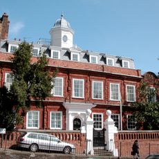
The site began in 1879 as Holborn Union Infirmary and was renamed to its current title in 1930 when it came under London County Council control. This shift reflected broader changes in how the city managed medical services and operated its healthcare facilities.

The hospital's Victorian brick buildings shape the local streetscape with their distinctive medical architecture that still conveys practical thinking about patient care from that era. Walking past reveals how building design once reflected beliefs about how hospitals should organize different kinds of treatment and rest.

The site comprises multiple separate buildings that can be explored on foot, with some structures visible from Archway Road and others set back on the grounds. Allow time to orient yourself as the various parts of the complex are not all immediately accessible or visible from a single vantage point.

In 1998 the complex was acquired by University College London and Middlesex University and transformed into an educational campus rather than remaining a hospital. This shift from active patient care to teaching facilities is a less obvious chapter in the site's story that many visitors overlook.

Location: England

GPS coordinates: 51.56696,-0.13607

Latest update: December 11, 2025 11:09

Photos
Around this place
Tomb of Karl Marx
United Kingdom

Tomb of Karl Marx

550 m
Cromwell House
United Kingdom

Cromwell House

575 m
Whittington Stone
United Kingdom

Whittington Stone

71 m
Lauderdale House
United Kingdom

Lauderdale House

561 m
Archway Tower
United Kingdom

Archway Tower

169 m
Church of St Joseph
United Kingdom

Church of St Joseph

456 m
Archway Bridge
United Kingdom

Archway Bridge

433 m
Church of St Augustine of Canterbury
United Kingdom

Church of St Augustine of Canterbury

624 m
St John's Church With St Peter's And Churchyard Wall And Gates
United Kingdom

St John's Church With St Peter's And Churchyard Wall And Gates

533 m
Archway Library
United Kingdom

Archway Library

138 m
Monument To Leslie Stephen In Highgate (Eastern) Cemetery
United Kingdom

Monument To Leslie Stephen In Highgate (Eastern) Cemetery

657 m
Parish Boundary Stone, North Side Of Junction With Dartmouth Park Hill
United Kingdom

Parish Boundary Stone, North Side Of Junction With Dartmouth Park Hill

500 m
Tomb Of Herbert Spencer In Highgate (Eastern) Cemetery
United Kingdom

Tomb Of Herbert Spencer In Highgate (Eastern) Cemetery

554 m
Tomb Of George Eliot In Highgate (Eastern) Cemetery
United Kingdom

Tomb Of George Eliot In Highgate (Eastern) Cemetery

570 m
F Block, St Mary's Wing, Whittington Hospital
United Kingdom

F Block, St Mary's Wing, Whittington Hospital

292 m
St Andrew's Whitehall Park
United Kingdom

St Andrew's Whitehall Park

277 m
Sundial Approximately 5 Metres From South Angle Of Lauderdale House
United Kingdom

Sundial Approximately 5 Metres From South Angle Of Lauderdale House

571 m
St Josephs Retreat
United Kingdom

St Josephs Retreat

430 m
Sundial To The South West Of Lauderdale House
United Kingdom

Sundial To The South West Of Lauderdale House

587 m
Tomb of George Holyoake
United Kingdom

Tomb of George Holyoake

553 m
K2 Telephone Kiosk North Side Of Junction With Dartmouth Park Hill
United Kingdom

K2 Telephone Kiosk North Side Of Junction With Dartmouth Park Hill

510 m
War Memorial at St Aloysius School
United Kingdom

War Memorial at St Aloysius School

418 m
Ireton House
United Kingdom

Ireton House

592 m
Garden Walls To The South West Of Lauderdale House
United Kingdom

Garden Walls To The South West Of Lauderdale House

563 m
Number 20 And Attached Railings
United Kingdom

Number 20 And Attached Railings

403 m
Number 8 And Attached Railings
United Kingdom

Number 8 And Attached Railings

434 m
2 And 4, Hornsey Lane
United Kingdom

2 And 4, Hornsey Lane

453 m
Forecourt Walls To Cromwell House
United Kingdom

Forecourt Walls To Cromwell House

575 m
Show the full map
Reviews

Visited this place? Tap the stars to rate it and share your experience / photos with the community! Try now! You can cancel it anytime.

« Archway Hospital - Hospital building in Highgate, England » is provided by Around Us (aroundus.com). Images and texts are derived from Wikimedia project under a Creative Commons license. You are allowed to copy, distribute, and modify copies of this page, under the conditions set by the license, as long as this note is clearly visible.

Discover hidden gems everywhere you go!

From secret cafés to breathtaking viewpoints, skip the crowded tourist spots and find places that match your style. Our app makes it easy with voice search, smart filtering, route optimization, and insider tips from travelers worldwide. Download now for the complete mobile experience.

Around Us App Screenshot

A unique approach to discovering new places

Le Figaro

All the places worth exploring

France Info

A tailor-made excursion in just a few clicks

20 Minutes