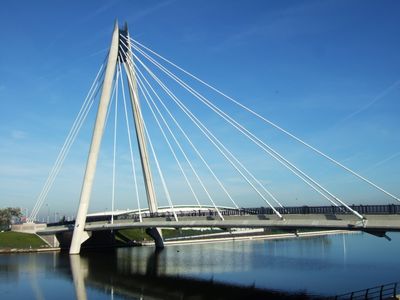
Marine Way Bridge, Cable-stayed bridge in Southport, England
The Marine Way Bridge is a cable-stayed structure in Southport that carries two traffic lanes across the waterway. The design features support cables extending from central towers to hold the deck above the water below.
A cast iron bridge previously stood at this location and served traffic until 1990, when it was eventually removed. The current structure was completed in 2004, replacing the older crossing and improving connections across the waterway.
The opening ceremony in 2004 brought prominent royal visitors to mark the bridge's importance to the local community. This recognition reflected how the structure connected different parts of town in a meaningful way.
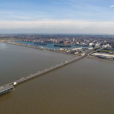
The bridge accommodates both vehicle traffic and pedestrians, making it suitable for daily commuting and crossing. The wide design ensures smooth traffic flow and the structure is built to handle various weather conditions.
The bridge was designed by Babtie and constructed by Balfour Beatty, two firms with extensive experience in major infrastructure work. This combination of expert design and skilled construction ensured the project could handle the demanding engineering challenges of crossing the waterway.
GPS coordinates: 53.65150,-3.00930
Latest update: December 14, 2025 09:41
Southport Pier
535 m
Atkinson Art Gallery and Library
534 m
Southport Town Hall
504 m
Southport Theatre
225 m
Wayfarers Arcade
418 m
Southport Model Railway Village
322 m
Southport War Memorial
449 m
Southport Arts Centre
526 m
Monumental Obelisk, Southport
335 m
St George's Church, Southport
518 m
Monument Of Queen Victoria
223 m
Church of St Marie (Roman Catholic)
483 m
Royal Clifton Hotel
477 m
Queens Hotel
326 m
Former Victoria Baths
220 m
130 Lord Street
497 m
Midland Bank
382 m
Shelter, Fifth In Series Of Five Ranging East West Round South End Of Marine Lake
511 m
Shelter, Second In Series Of Five Ranging East West Round South End Of Marine Lake
457 m
Shelter, Third In Series Of Five Ranging East West Round South End Of Marine Lake
492 m
Shelter, Fourth In Series Of Five Ranging East West Round South End Of Marine Lake
514 m
Fernley Drinking Fountain, Southport
229 m
Shelter Opposite Number 10 (Number 10 Not Included)
413 m
Shelter Opposite Number 30
259 m
Shelter Within Kings Gardens And South Marine Gardens Opposite Coronation Walk
513 m
Two K6 Telephone Kiosks Adjacent to Christ Church
490 m
Shelter, First In Series Of Five Ranging East West Round South End Of Marine Lake
393 m
367, Lord Street
405 mVisited this place? Tap the stars to rate it and share your experience / photos with the community! Try now! You can cancel it anytime.
Discover hidden gems everywhere you go!
From secret cafés to breathtaking viewpoints, skip the crowded tourist spots and find places that match your style. Our app makes it easy with voice search, smart filtering, route optimization, and insider tips from travelers worldwide. Download now for the complete mobile experience.
A unique approach to discovering new places❞
— Le Figaro
All the places worth exploring❞
— France Info
A tailor-made excursion in just a few clicks❞
— 20 Minutes