Stoke Newington Municipal Buildings And Surrounding Walls

Log in to your account

AroundUs is a community-driven map of interesting places, built by curious explorers like you. It grows with every review, story, and photo you share.
Connect to save your favorite spots, contribute locations, and create personalized routes.
By continuing, you accept our Terms and Conditions and our Privacy Policy

Stoke Newington Municipal Buildings And Surrounding Walls

Add to collection
Map
Suggest a change
Share

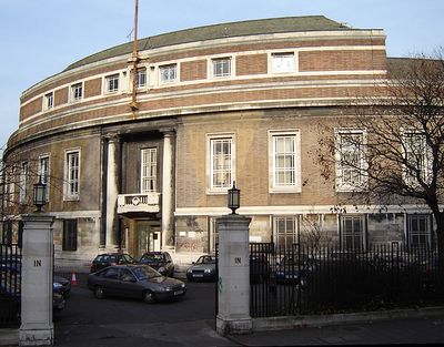
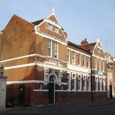
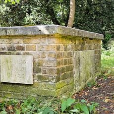
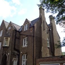
Stoke Newington Municipal Buildings And Surrounding Walls, Grade II listed municipal building in Stoke Newington, United Kingdom.
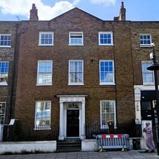
The municipal structure presents a symmetrical curved frontage with fifteen bays and incorporates Renaissance style architecture throughout its primary sections.

The building replaced previous council offices in Milton Grove and was completed in 1937 by architect John Reginald Truelove on the site of a former manor house.

The assembly hall with its Canadian maple dance floor serves as a central gathering space for community events in the London Borough of Hackney.

Following a £6.4 million renovation in 2010, the building received modern updates while maintaining its historical wooden paneling and architectural features.

The structure functioned as a civil defense headquarters during World War II and underwent extensive camouflage to protect it from London Blitz bombings.

Location: London Borough of Hackney

Inception: 1937

Architects: John Reginald Truelove

Accessibility: Wheelchair accessible

GPS coordinates: 51.56155,-0.08326

Latest update: March 2, 2025 20:15

Around this place
Show the full map
Clissold Park
United Kingdom

Clissold Park

581 m
St Mary, Stoke Newington
United Kingdom

St Mary, Stoke Newington

114 m
Old Church of St Mary
United Kingdom

Old Church of St Mary

104 m
Rose and Crown
United Kingdom

Rose and Crown

67 m
Clissold Park
United Kingdom

Clissold Park

352 m
War memorial at the Church of St Mary
United Kingdom

War memorial at the Church of St Mary

131 m
130, Stoke Newington Church Street N16
United Kingdom

130, Stoke Newington Church Street N16

208 m
109 And 111, Stoke Newington Church Street N16
United Kingdom

109 And 111, Stoke Newington Church Street N16

261 m
91, Stoke Newington Church Street N16
United Kingdom

91, Stoke Newington Church Street N16

322 m
137, Stoke Newington Church Street N16
United Kingdom

137, Stoke Newington Church Street N16

163 m
105 And 107, Stoke Newington Church Street N16
United Kingdom

105 And 107, Stoke Newington Church Street N16

263 m
183, Stoke Newington Church Street N16
United Kingdom

183, Stoke Newington Church Street N16

56 m
89, Stoke Newington Church Street N16
United Kingdom

89, Stoke Newington Church Street N16

332 m
115, Stoke Newington Church Street N16
United Kingdom

115, Stoke Newington Church Street N16

231 m
117, Stoke Newington Church Street N16
United Kingdom

117, Stoke Newington Church Street N16

229 m
177-181, Stoke Newington Church Street N16
United Kingdom

177-181, Stoke Newington Church Street N16

56 m
113, Stoke Newington Church Street N16
United Kingdom

113, Stoke Newington Church Street N16

238 m
Stoke Newington Library
United Kingdom

Stoke Newington Library

33 m
The Clarence Tavern
United Kingdom

The Clarence Tavern

309 m
Forecourt Wall To Church And Rectory Of St Mary
United Kingdom

Forecourt Wall To Church And Rectory Of St Mary

106 m
Park Crescent
United Kingdom

Park Crescent

194 m
Tomb Of Anna Laetitia Barbauld, Churchyard Of Old Church Of St Mary
United Kingdom

Tomb Of Anna Laetitia Barbauld, Churchyard Of Old Church Of St Mary

116 m
Tomb Of James Stephen, Churchyard Of Old Church Of St Mary
United Kingdom

Tomb Of James Stephen, Churchyard Of Old Church Of St Mary

93 m
Forecourt Walls To Number 91
United Kingdom

Forecourt Walls To Number 91

326 m
Bilney Lodge
United Kingdom

Bilney Lodge

178 m
Stone Near East Gate Of Park
United Kingdom

Stone Near East Gate Of Park

243 m
St Mary's Rectory
United Kingdom

St Mary's Rectory

143 m
8, Lordship Road N16
United Kingdom

8, Lordship Road N16

185 m
Show the full map

Reviews

Visited this place? Tap the stars to rate it and share your experience / photos with the community! Try now! You can cancel it anytime.

« Stoke Newington Municipal Buildings And Surrounding Walls - Grade II listed municipal building in Stoke Newington, United Kingdom » is provided by Around Us (aroundus.com). Images and texts are derived from Wikimedia project under a Creative Commons license. You are allowed to copy, distribute, and modify copies of this page, under the conditions set by the license, as long as this note is clearly visible.

Discover hidden gems everywhere you go!

From secret cafés to breathtaking viewpoints, skip the crowded tourist spots and find places that match your style. Our app makes it easy with voice search, smart filtering, route optimization, and insider tips from travelers worldwide. Download now for the complete mobile experience.

Around Us App Screenshot

A unique approach to discovering new places

Le Figaro

All the places worth exploring

France Info

A tailor-made excursion in just a few clicks

20 Minutes