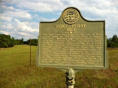
Enable Location

We need your location to show you interesting places around you

Discover nearby places

Find interesting locations and hidden gems around you

Precise directions

Get accurate directions and distances to places

Your location is never shared with other users. It's only used when you tap the location button.

Fort Perry

Log in to your account

Start exploring — it's free

Trusted by 62,568 travelers worldwide

Continue with Google
Continue with Apple
or

We will send you a code to connect

By continuing, you accept our Terms and Conditions and our Privacy Policy

Check your inbox

We've sent a pincode in your inbox. Please enter the code below.

Fort Perry

Fort Perry

Fort Perry was a fortification in Georgia built in the early 1800s, covering about 30 acres along the Old Federal Road. The wooden structure had an eight-sided star shape with blockhouses and earthen walls that allowed for quick construction and effective defense.

Fort Perry was built in 1813 by Georgia militia under General John Floyd as a quick defensive outpost. The fort served a supporting role during the Creek War from 1813 to 1814, securing supply lines for troops fighting the Red Sticks.

The fort is marked only by a historic sign today and sits near Buena Vista along Georgia Route 41, north of Fort Perry Road. The location is easy to reach, and you can still see the old road route where the fort once stood.

The fort had an unusual eight-pointed star shape still visible in aerial images today, a rare design for fortifications of that time in the South. After the war it quickly deteriorated, but its distinctive geometric pattern later helped historians pinpoint its exact location and structure.

The community of curious travelers

AroundUs brings together thousands of curated places, local tips, and hidden gems, enriched daily by 60,000 contributors worldwide.

Start exploring
GPS coordinates
32.47806,-84.54417
Latest update
February 9, 2026 07:42
Around this place
National Infantry Museum
United States of America

National Infantry Museum

39.9 km
Pasaquan
United States of America

Pasaquan

15.1 km
Chattahoochee RiverWalk
United States of America

Chattahoochee RiverWalk

40.3 km
A. J. McClung Memorial Stadium
United States of America

A. J. McClung Memorial Stadium

41.5 km
Aflac Building
United States of America

Aflac Building

39.4 km
Linwood Cemetery
United States of America

Linwood Cemetery

41.2 km
National Civil War Naval Museum at Port Columbus
United States of America

National Civil War Naval Museum at Port Columbus

41.1 km
Columbus Museum
United States of America

Columbus Museum

40.4 km
St. Elmo
United States of America

St. Elmo

39.6 km
Church of the Holy Family
United States of America

Church of the Holy Family

41.7 km
Shiloh-Marion Baptist Church and Cemetery
United States of America

Shiloh-Marion Baptist Church and Cemetery

35.4 km
Riverside
United States of America

Riverside

40.9 km
Dinglewood House
United States of America

Dinglewood House

40.2 km
Hilton
United States of America

Hilton

38.5 km
The Columbus Museum
United States of America

The Columbus Museum

40.4 km
National Civil War Naval Museum
United States of America

National Civil War Naval Museum

41 km
First African Baptist Church Parsonage
United States of America

First African Baptist Church Parsonage

41.6 km
Taylor County Courthouse
United States of America

Taylor County Courthouse

30.1 km
Secondary Industrial School
United States of America

Secondary Industrial School

40.8 km
Bullard-Hart House
United States of America

Bullard-Hart House

41.8 km
Cusseta Industrial High School
United States of America

Cusseta Industrial High School

29.2 km
Butler Downtown Historic District
United States of America

Butler Downtown Historic District

30.1 km
Marion County Courthouse
United States of America

Marion County Courthouse

18 km
Schley County Courthouse
United States of America

Schley County Courthouse

34.7 km
Old Marion County Courthouse
United States of America

Old Marion County Courthouse

14.6 km
Talbot County Courthouse
United States of America

Talbot County Courthouse

22.1 km
Psalmond Road Water Park
United States of America

Psalmond Road Water Park

30.1 km
Liberty Theatre
United States of America

Liberty Theatre

41.2 km
Show the full map
« Fort Perry » is provided by Around Us (aroundus.com). Images and texts are derived from Wikimedia project under a Creative Commons license. You are allowed to copy, distribute, and modify copies of this page, under the conditions set by the license, as long as this note is clearly visible.

Discover hidden gems everywhere you go!

From secret cafés to breathtaking viewpoints, skip the crowded tourist spots and find places that match your style. Our app makes it easy with voice search, smart filtering, route optimization, and insider tips from travelers worldwide. Download now for the complete mobile experience.

Around Us App Screenshot

A unique approach to discovering new places

Le Figaro

All the places worth exploring

France Info

A tailor-made excursion in just a few clicks

20 Minutes

Around Us
Travel Guide & Maps
Download

Send to your phone

QR Code
1

Open the camera app on your mobile.

2

Point at the QR code with your camera. A notification will appear.

3

Tap the notification to open the link.