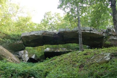
Natural Bridge of Arkansas, Natural arch in Van Buren County, United States.
The Natural Bridge of Arkansas is a sandstone arch spanning Little Johnny Creek in a forested setting. The formation was carved by water erosion over millions of years and stands above the creek bed.
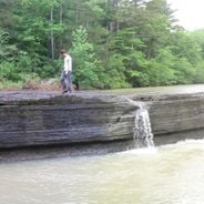
Loggers used this passage in the late 1800s to transport timber across the region as railroads expanded. The natural formation provided a convenient crossing point during the timber industry boom.
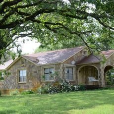
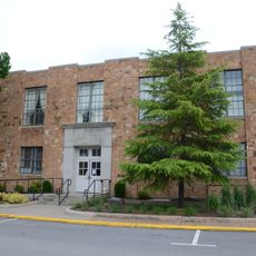
The site reflects rural settlement patterns and how people adapted to living near the creek. The two cabins offer visitors a glimpse into daily life during the frontier era.
Marked trails lead visitors through the wooded area to the bridge and surrounding features. A rock shelter built into the bluff provides shade and a place to rest while exploring.
The stone structure is roughly 3 million years old and shows how persistent water action shapes rock over vast time spans. Visitors can observe different layers and patterns in the sandstone that reveal geological processes.
Location: Van Buren County
GPS coordinates: 35.65215,-92.45280
Latest update: December 6, 2025 19:04
Arkansas sits in the southern United States, where the Ozark and Ouachita mountains meet forested valleys and slow rivers. Away from the main highways, the state holds waterfalls hidden in national forests, abandoned settlements from mining days, and caves filled with limestone formations. Haw Creek Falls drops over a series of ledges in the Ozarks, while Blanchard Springs Caverns opens into chambers where underground streams have carved stone over thousands of years. Rush, once a zinc mining town, now stands empty along the Buffalo River. Boxley Valley offers open fields where elk graze beneath ridges, and the Cossatot River cuts through rocky rapids in the Ouachita range. These places show different chapters of the region's natural and human history. Historical sites and cultural centers add depth to the landscape. Monte Ne preserves the ruins of an early resort built beside Beaver Lake. The Hampson Archeological Museum holds artifacts from indigenous peoples who lived in the Mississippi River floodplain. Jacksonport once served as a river port on the White River, and the Delta Cultural Center documents the agricultural heritage of eastern Arkansas. From Sam's Throne, a rock outcrop with views across the Ozarks, to the old railway bridge in Clarendon, these locations lie off the usual routes and reward those who take the time to seek them out.
Melvin Chrisco House
31.5 km
Middle Fork of the Little Red River Bridge
11.9 km
Van Buren County Courthouse
6.7 km
Old Highway 16 Bridge
24.6 km
Alco School
27.6 km
Farmers Bank Building
21.9 km
Dr. J.O. Cotton House
22 km
Dr. Clay House
22 km
Joclin-Bradley-Bowling House
6.2 km
Jasper E. Treece Building
31.1 km
Collums-Baker House
23.9 km
Bluff Springs Church and School
30.8 km
Damascus CCC Camp, Co. No. 3781 Historic District
31.7 km
Columbus Hatchett House
21.7 km
Van Buren County Road 2E Bridge
27.2 km
American Legion Post No. 131
22 km
Damascus Gymnasium
31.9 km
Leslie Commercial Historic District
22 km
Walter Patterson House
4.5 km
Brewer School
24.5 km
Leslie-Rolen House
21.9 km
Clinton Commercial Historic District
6.4 km
Art Scanlan House
23.4 km
Guy Bartley House
22.3 km
J.C. Miller House
22.2 km
Greene Thomas House
25.2 km
Dr. Cleveland Hollabaugh House
22.2 km
Newton Sutterfield Farmstead
29.5 kmVisited this place? Tap the stars to rate it and share your experience / photos with the community! Try now! You can cancel it anytime.
Discover hidden gems everywhere you go!
From secret cafés to breathtaking viewpoints, skip the crowded tourist spots and find places that match your style. Our app makes it easy with voice search, smart filtering, route optimization, and insider tips from travelers worldwide. Download now for the complete mobile experience.
A unique approach to discovering new places❞
— Le Figaro
All the places worth exploring❞
— France Info
A tailor-made excursion in just a few clicks❞
— 20 Minutes