Tet Paul Nature trail, Nature trail in Saint Lucia
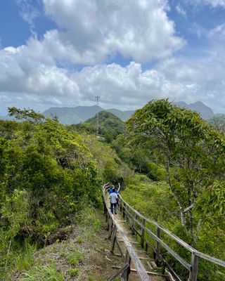
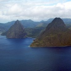
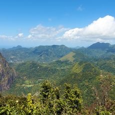
Tet Paul Nature Trail is a walking path in Soufrière that offers views of the Pitons and the coastline below. The route passes through wooded areas with fruit trees and traditional buildings, covering roughly half a mile.
The path was originally a route used by farmers to work their land and connect settlements in the area. Over time it became a destination for visitors and is now part of a nature reserve that protects the landscape and its wildlife.
The trail reflects how local people have shaped the landscape over time through farming and daily life. Visitors encounter traditional houses and fruit farms that reveal the connection between residents and their surroundings.
The path is straightforward to locate with clear markings, reachable about a few kilometers from Soufrière. Wear comfortable shoes, bring water, and visit in the morning when the air is cool and fresh for the best experience.
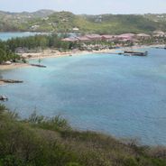
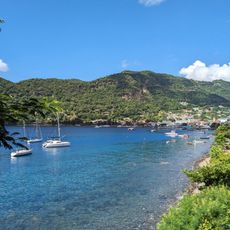
A highlight is the Stairway to Heaven, which climbs to a viewpoint overlooking both the Gros Piton and Petit Piton in the distance. From this spot, visitors can also see Jalousie Bay and Vieux Fort spread across the water.
Location: Soufrière
Fee: Adults & Junior Us$10 per person, Children under 10yrs Us$5 per child.
Opening Hours: Lunes-Domingo 08:00-17:30; Festivos open
Phone: +1(758)4571122
GPS coordinates: 13.81996,-61.05499
Latest update: December 8, 2025 20:52
Saint Lucia combines volcanic landforms with tropical rainforest and coastal stretches shaped by both Atlantic and Caribbean waters. The island ranges from sea level to peaks reaching nearly 1,000 meters (3,280 feet), creating varied environments for photography. You will find subjects that include steep mountain formations, sheltered bays and historical structures set against natural backdrops. Places like the Pitons near Soufrière show the island's volcanic past, while beaches such as Anse Chastanet and Jalousie Beach offer contrasts between dark and light sand. Marigot Bay and Rodney Bay serve as natural harbors that have anchored vessels for centuries. Historical sites like Pigeon Island National Landmark and La Toc Battery recall colonial conflicts between European powers. Trails such as Tet Paul Nature Trail and routes to Mount Gimie pass through vegetation that shifts with elevation. Waterfalls like Enbas Saut and Sapphire Falls lie inland, where rivers cut through rock formations. Coastal spots like Cas en Bas Beach and Grande Anse Beach show different shoreline patterns, from rocky sections to open sand.
Pitons
1.6 km
Qualibou
2.2 km
Sulfur Springs
2.2 km
Bat Cave, Saint Lucia
2.3 km
Piton Falls
2.2 km
Sulphur springs
2.3 km
Sapphire Waterfall
2.8 km
Sugar Beach
1.1 km
Malgretoute Beach
2.6 km
Malgretoute Beach
2.6 km
Scenic viewpoint
303 m
Morne Coubaril Historical Adventure Park
3 km
The BEST VIEW OF CARRIBEAN
1.2 km
Anse L'Ivrogne Beach
2.6 km
Sulphur Springs Park
2.4 km
Mirror Ball's
1 km
Sugar Beach
1.2 km
Gros Piton Viewpoint
1.6 km
Project Chocolate
1.7 km
Big Nature
1.8 km
Scenic viewpoint
2.2 km
UNESCO World Heritage
2.9 km
Scenic viewpoint
77 m
Scenic viewpoint
398 m
Scenic viewpoint
334 m
Scenic viewpoint
173 m
Piton Falls
2.2 km
Superman Waterfall
3 kmVisited this place? Tap the stars to rate it and share your experience / photos with the community! Try now! You can cancel it anytime.
Discover hidden gems everywhere you go!
From secret cafés to breathtaking viewpoints, skip the crowded tourist spots and find places that match your style. Our app makes it easy with voice search, smart filtering, route optimization, and insider tips from travelers worldwide. Download now for the complete mobile experience.
A unique approach to discovering new places❞
— Le Figaro
All the places worth exploring❞
— France Info
A tailor-made excursion in just a few clicks❞
— 20 Minutes