Tongariro Alpine Crossing

Log in to your account

AroundUs is a community-driven map of interesting places, built by curious explorers like you. It grows with every review, story, and photo you share.
Connect to save your favorite spots, contribute locations, and create personalized routes.
By continuing, you accept our Terms and Conditions and our Privacy Policy

Tongariro Alpine Crossing

Add to collection
Map
Suggest a change
Share

Tongariro Alpine Crossing, Hiking trail in Tongariro National Park, New Zealand

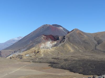
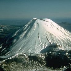
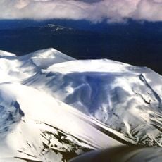
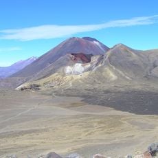
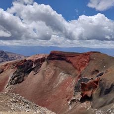
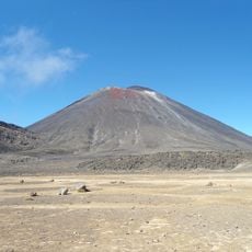
The route traverses the central volcanic peaks of Tongariro National Park, gaining over 2500 feet (760 meters) in elevation. The path passes through multiple climate zones, from tussock grasslands to alpine desert and active thermal areas with sulfur vents. Hikers move past the Te Maari Crater before ascending to Red Crater, the highest point at 6188 feet (1886 meters).

Paramount Chief Te Heuheu Tukino IV gifted the three volcanoes to the Crown in 1887 to protect them from European settlement. The track was originally used by Māori as a travel route before being formalized for recreational hikers during the 1970s. A major Te Maari Crater eruption in 2012 temporarily closed the path and led to enhanced monitoring systems.

The region is classified as tapu (sacred) to Māori, connected to ancestral spirits and spiritual forces. Local iwi co-manage the track with the Department of Conservation and ask visitors to respect the religious importance of the volcanoes by refraining from eating or relieving themselves on the summits.

The 19.4-kilometer track typically requires six to eight hours. Shuttle buses operate daily between the Mangatepopo start point and Ketetahi end point from October through May. Weather changes frequently; hikers should carry warm waterproof clothing, sufficient water and sun protection. Bookings are required during peak season, and a parking fee applies. Toilets are available only at the endpoints.

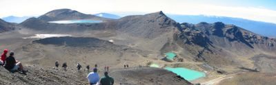
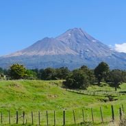
The two Emerald Lakes below Red Crater derive their bright turquoise hues from minerals leached from surrounding thermal vents. Nearby lies Blue Lake (Rotopounamu), which is sacred to Māori and where swimming or water collection is strictly prohibited. On clear days, both Mount Taranaki to the west and Mount Ruapehu are visible from several points along the route.

Location: Ruapehu District

Location: Taupō District

Operator: Department of Conservation

Website: https://doc.govt.nz/parks-and-recreation/places-to-go/central-north-island/places/tongariro-national-park/things-to-do/tracks/tongariro-alpine-crossing

GPS coordinates: -39.07394,175.66380

Latest update: December 2, 2025 09:18

Photos
Instagrammable spots across New Zealand

New Zealand provides photographic subjects ranging from the Southern Alps to sand beaches on both coastlines. The landscape includes thermal springs in Rotorua, glaciers like Franz Josef and Tasman, and fjords in Fiordland. Mount Cook dominates the alpine region while the Coromandel Peninsula holds beaches including Hot Water Beach and Cathedral Cove. The Tongariro Alpine Crossing traverses volcanic terrain and Mount Taranaki rises above Taranaki. Coastal formations like the Moeraki Boulders, Split Apple Rock and Nugget Point demonstrate geological variety. Natural waterfalls including Purakaunui Falls and Whangarei Falls sit among native forests. Cultural sites complement the natural geography. The Hobbiton Movie Set near Matamata displays the film location from the Tolkien adaptation. Larnach Castle near Dunedin represents colonial architecture. Te Puia and Wai-O-Tapu demonstrate geothermal activity with geysers and colored pools. Waitomo Caves contains glowworm caverns. Lake Tekapo offers clear night skies for stargazing. Viewpoints like Roy's Peak near Wanaka and Queenstown Hill sit above lake landscapes. Remote regions including Cape Reinga at the northern tip and Cape Palliser in the Wairarapa show different coastal environments. The Forgotten World Highway crosses historic mountain country on the North Island.

Reviews

Visited this place? Tap the stars to rate it and share your experience / photos with the community! Try now! You can cancel it anytime.

« Tongariro Alpine Crossing - Hiking trail in Tongariro National Park, New Zealand » is provided by Around Us (aroundus.com). Images and texts are derived from Wikimedia project under a Creative Commons license. You are allowed to copy, distribute, and modify copies of this page, under the conditions set by the license, as long as this note is clearly visible.

Discover hidden gems everywhere you go!

From secret cafés to breathtaking viewpoints, skip the crowded tourist spots and find places that match your style. Our app makes it easy with voice search, smart filtering, route optimization, and insider tips from travelers worldwide. Download now for the complete mobile experience.

Around Us App Screenshot

A unique approach to discovering new places

Le Figaro

All the places worth exploring

France Info

A tailor-made excursion in just a few clicks

20 Minutes