Golfclub Wiggensbach-Waldegg e.V., Golf course in Wiggensbach, Germany.
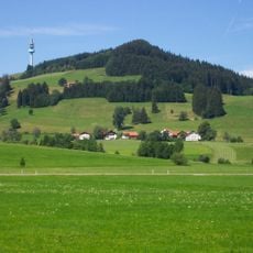
Golfclub Wiggensbach-Waldegg is a 27-hole golf course laid out across rolling terrain with mature trees and integrated landscape features. The facility sits at approximately 3,300 feet (1,000 meters) elevation with views toward the Alpine range.
The course was founded in 1988 and grew from a small local operation into a regional sports facility serving a wider area. Multiple course configurations were gradually introduced to accommodate different playing styles and skill levels.
The course serves as a meeting place for players who gather regularly to train and compete in organized events. The clubhouse acts as a social hub where visitors connect through their shared interest in the sport.
The course features 30 different starting positions that allow visitors to adjust the difficulty based on skill level. Advance reservations are recommended and a valid handicap certificate is needed to play most of the available routes.
The site hosts the highest elevated tee area in Germany, offering a distinct viewpoint over the entire layout. Seven of the starting positions include covered areas, allowing play to continue even in wet weather.
Location: Wiggensbach
Address: Hof Waldegg
Opening Hours: Monday-Sunday 09:00-17:00
Phone: +49837093073
Email: info@golf-wiggensbach.com
Website: http://golf-wiggensbach.com
GPS coordinates: 47.74861,10.19869
Latest update: December 6, 2025 19:07
Golf courses in Germany span from seaside links to alpine settings. Players access modern practice facilities, tournament-standard layouts, and varied course designs. Venues include historic clubs from 1895, championship courses, and modern resorts. Locations range from Baltic coastal areas to mountain elevations of 1200 meters.
Blender
2.9 km
Blender (tranmission plant)
3 km
Pfarrkirche St. Pankratius (Wiggensbach)
2.5 km
St. Ulrich
1.4 km
Burg Suseck
1.7 km
St. Martin
2.8 km
St. Michael
3.5 km
Marienkapelle
808 m
Marienkapelle
3 km
Zu den sieben Zufluchten
1.5 km
Kapelle
2.6 km
Kapelle (Winnings)
2.4 km
Unterkürnach Bildstock
2.6 km
Kapelle
3.6 km
Kapelle
1.6 km
Kapellenbildstock
1.4 km
Kapelle
2 km
Historische Ausstattungsstücke in moderner Kapelle
3.2 km
St. Nepomuk statue
2.7 km
Ehemaliges Bauernhaus
1.7 km
Bauernhaus
3.4 km
Bauernhaus
570 m
Herrenhaus
2.6 km
Bildstock
3.3 km
Bauernhaus
2.8 km
Ehemaliges Bauernhaus
1.7 km
Bildstock
1.6 km
Wohnteil eines ehemaligen Bauernhauses
1.7 kmReviews
Visited this place? Tap the stars to rate it and share your experience / photos with the community! Try now! You can cancel it anytime.
Discover hidden gems everywhere you go!
From secret cafés to breathtaking viewpoints, skip the crowded tourist spots and find places that match your style. Our app makes it easy with voice search, smart filtering, route optimization, and insider tips from travelers worldwide. Download now for the complete mobile experience.
A unique approach to discovering new places❞
— Le Figaro
All the places worth exploring❞
— France Info
A tailor-made excursion in just a few clicks❞
— 20 Minutes