Die Kö
Location: Schalkenmehren
Inception: January 1, 1949
GPS coordinates: 50.16902,6.86996
Latest update: November 20, 2025 00:25
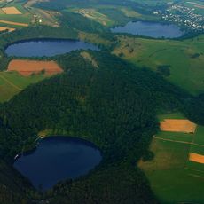
Dauner Maare
1.1 km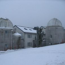
Hoher List Observatory
1.7 km
Vulkanland Eifel Geopark
1.8 km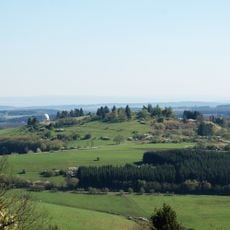
Hoher List
1.7 km
Segelfluggelände Daun-Senheld
1.2 km
West Eifel Volcanic Field
1.4 km
Eifelmaare
1.2 km
Scenic viewpoint
1.3 km
Wayside shrine, Christianity
1.1 km
Schalkenmehrener Maar
1.3 km
Maarkreuz
1 km
Scenic viewpoint
1.4 km
Scenic viewpoint
1.6 km
Scenic viewpoint
1.2 km
Naturfreibad Schalkenmehrener Maar
1 km
Scenic viewpoint
1.2 km
Scenic viewpoint
783 m
Scenic viewpoint
1.4 km
Scenic viewpoint
1.3 km
Wayside shrine, Christianity
1.3 km
War memorial, memorial
777 m
Catholic church building, wayside shrine, Christianity
1.4 km
Wegkreuz
1.1 km
Flucht aus Ägypten
1.7 km
Catholic church building, wayside shrine, Christianity
628 m
Catholic church building, wayside cross, Christianity
1 km
Wayside shrine, Christianity
779 m
Wayside cross
630 mReviews
Visited this place? Tap the stars to rate it and share your experience / photos with the community! Try now! You can cancel it anytime.
Discover hidden gems everywhere you go!
From secret cafés to breathtaking viewpoints, skip the crowded tourist spots and find places that match your style. Our app makes it easy with voice search, smart filtering, route optimization, and insider tips from travelers worldwide. Download now for the complete mobile experience.

A unique approach to discovering new places❞
— Le Figaro
All the places worth exploring❞
— France Info
A tailor-made excursion in just a few clicks❞
— 20 Minutes