Eifelmaare, protected area in the European Union defined by the habitats directive in Rheinland-Pfalz, Germany
Location: Meerfeld
Location: Bettenfeld
Location: Gillenfeld
Location: Eckfeld
Location: Strohn
Location: Strotzbüsch
Location: Mehren
Location: Ellscheid
Location: Udler
Location: Schalkenmehren
Location: Daun
Location: Ulmen
Location: Sassen
Location: Mosbruch
Location: Kolverath
Location: Kelberg
Inception: 1998
GPS coordinates: 50.17836,6.86082
Latest update: November 20, 2025 00:25
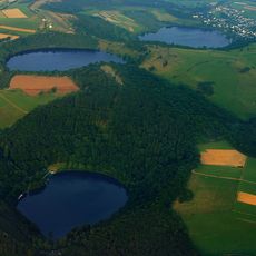
Dauner Maare
663 m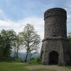
Dronketurm
1.4 km
Vulkanland Eifel Geopark
932 m
Segelfluggelände Daun-Senheld
348 m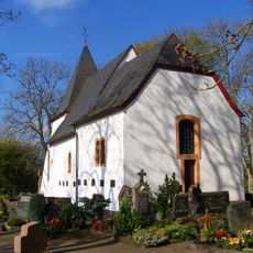
Sint-Martinuskerk
835 m
Mäuse Berg
1.4 km
West Eifel Volcanic Field
1.2 km
Scenic viewpoint
817 m
Scenic viewpoint
1.4 km
Scenic viewpoint
767 m
Scenic viewpoint
1.1 km
Schalkenmehrener Maar
980 m
Priorfels
1 km
Maarkreuz
436 m
Die Kö
1.2 km
Scenic viewpoint
596 m
Scenic viewpoint
737 m
Scenic viewpoint
1.4 km
Naturfreibad Schalkenmehrener Maar
1.2 km
Wayside shrine, Christianity
1.4 km
Eisener Kreuz
1 km
Wayside shrine, Christianity
671 m
War memorial, memorial
1.4 km
Catholic church building, wayside shrine, Christianity
1.3 km
Adolf Dronke
1.4 km
Catholic church building, wayside shrine, Christianity
1.3 km
Wayside shrine, Christianity
573 m
Wayside cross
1.2 kmReviews
Visited this place? Tap the stars to rate it and share your experience / photos with the community! Try now! You can cancel it anytime.
Discover hidden gems everywhere you go!
From secret cafés to breathtaking viewpoints, skip the crowded tourist spots and find places that match your style. Our app makes it easy with voice search, smart filtering, route optimization, and insider tips from travelers worldwide. Download now for the complete mobile experience.

A unique approach to discovering new places❞
— Le Figaro
All the places worth exploring❞
— France Info
A tailor-made excursion in just a few clicks❞
— 20 Minutes