Burgruine Weißenstein
Location: Waldershof
Accessibility: Wheelchair inaccessible
GPS coordinates: 49.91376,12.08321
Latest update: October 11, 2024 04:17
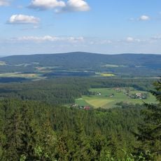
Steinwald
239 m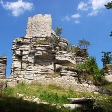
Burg Weißenstein
12 m
Plößberg
1.6 km
Ehemaliges Wohnstallhaus, Einödhof
1.6 km
Cultural heritage D-3-6038-0012 in Waldershof
10 m
Scenic viewpoint
30 m
Wayside shrine
1.5 km
Kiebitzstein
126 m
Mutter Erde
9 m
Wayside shrine, Christianity
580 m
Wolf-Dieter von Gemmingen-Hornberg Brunnen
1 km
Schlossfelsen
1.1 km
Catholic church building, wayside cross, Christianity
1.3 km
Wolfsgrube
1.3 km
Basaltpferde
1.4 km
Wayside shrine, Christianity
1.4 km
Burgruine Weißenstein
24 m
Waldhaus=Strasse
1.6 km
Wayside cross
1.6 km
Wayside cross
3 m
Burgruine Weißenstein
2 m
Wayside shrine
1.8 km
Catholic church building, wayside cross, Christianity
1.8 km
Wayside cross
1.8 km
Wayside shrine
1.8 km
Wayside shrine, Christianity
1.8 km
Catholic church building, wayside shrine, Christianity
1.9 km
Wayside cross
2 kmReviews
Visited this place? Tap the stars to rate it and share your experience / photos with the community! Try now! You can cancel it anytime.
Discover hidden gems everywhere you go!
From secret cafés to breathtaking viewpoints, skip the crowded tourist spots and find places that match your style. Our app makes it easy with voice search, smart filtering, route optimization, and insider tips from travelers worldwide. Download now for the complete mobile experience.

A unique approach to discovering new places❞
— Le Figaro
All the places worth exploring❞
— France Info
A tailor-made excursion in just a few clicks❞
— 20 Minutes