☮
Location: Bernalillo County
GPS coordinates: 35.17647,-106.34362
Latest update: November 21, 2025 00:46
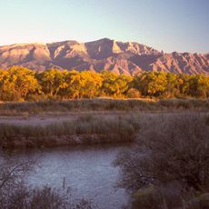
Sandia Mountains
10.3 km
Sandia Mountain Wilderness
10 km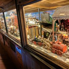
Tinkertown Museum
2.3 km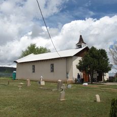
San Antonito Church and Cemetery
1.4 km
Sandia Mountains Historical Marker
10.1 km
Gutierrez Canyon Open Space
5.6 km
Scenic viewpoint
9.3 km
Domingo Baca Canyon Overlook
9.6 km
Overlook
9.1 km
Scenic viewpoint
7.7 km
Scenic viewpoint
4.7 km
Madera Overlook
7 km
Southern Sandias Overlook
7.9 km
Pino Canyon Overlook
7.2 km
Paa-Ko Ridge Golf Club
3.8 km
Scenic Overlook
9.9 km
Bodhi Tree
10.1 km
66
7.8 km
Upper La Cueva Canyon, La Luz Overlook
10.3 km
Scenic viewpoint
4.7 km
The Washout
8.8 km
Crinoid Fossils
8.7 km
Crinoid Fossils
8.6 km
Travertine Falls
10.1 km
Waterfall
8.9 km
Waterfall
9.8 km
Waterfall
9.1 km
Waterfall
10.2 kmReviews
Visited this place? Tap the stars to rate it and share your experience / photos with the community! Try now! You can cancel it anytime.
Discover hidden gems everywhere you go!
From secret cafés to breathtaking viewpoints, skip the crowded tourist spots and find places that match your style. Our app makes it easy with voice search, smart filtering, route optimization, and insider tips from travelers worldwide. Download now for the complete mobile experience.

A unique approach to discovering new places❞
— Le Figaro
All the places worth exploring❞
— France Info
A tailor-made excursion in just a few clicks❞
— 20 Minutes