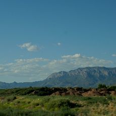
Sandia Mountain Wilderness, Protected wilderness area in Cibola National Forest, New Mexico.
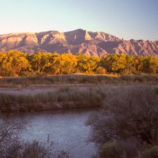
Sandia Mountain Wilderness lies mostly on the western side of the Sandia Mountains, a range about 18 miles long north to south and 8 miles wide, east of Albuquerque. The dominant rock is granite, with a ribbon of limestone running along the crest. Upper elevations carry firs and spruce, while ponderosa pines and conifers grow at middle elevations.
The wilderness received federal protection in 1978 when Congress designated it as part of the National Wilderness Preservation System. The designation included boundary adjustments through the 1980s to better protect the mountain ecosystem.
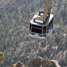
The name Sandia means watermelon in Spanish, referring to the reddish hue the mountains take at sunset. Visitors today reach the range by the Sandia Peak Aerial Tramway, a 2.7-mile (4.3 km) ride climbing nearly 4,000 feet (1,200 m) to the crest, built by Swiss engineers and opened in 1966. The Crest Trail runs about 26.5 miles (42.6 km) along the ridge at an average elevation of 10,000 feet (3,000 m).
Most visitors reach the wilderness by the Sandia Peak Aerial Tramway, a 2.7-mile (4.3 km) ride climbing nearly 4,000 feet (1,200 m) to the crest, or by driving the Sandia Crest National Scenic Byway. From the top terminal at 10,300 feet (3,100 m), the Crest Trail runs about 26.5 miles (42.6 km) along the ridge at an average elevation of 10,000 feet (3,000 m). The Forest Service maintains roughly 117 miles (188 km) of trails, mostly on the western side.
The elevation gain transitions from warm desert conditions at the base to cool alpine forest at the summit, all within a short distance. These rapid shifts allow visitors to experience multiple entirely different environments in a single outing.
The community of curious travelers
AroundUs brings together thousands of curated places, local tips, and hidden gems, enriched daily by 93,874 contributors worldwide.