Enable Location

We need your location to show you interesting places around you

Discover nearby places

Find interesting locations and hidden gems around you

Precise directions

Get accurate directions and distances to places

Your location is never shared with other users. It's only used when you tap the location button.

Sandia Peak Tramway

Log in to your account

Start exploring — it's free

Trusted by 62,533 travelers worldwide

Continue with Google
Continue with Apple
or

We will send you a code to connect

By continuing, you accept our Terms and Conditions and our Privacy Policy

Check your inbox

We've sent a pincode in your inbox. Please enter the code below.

Sandia Peak Tramway

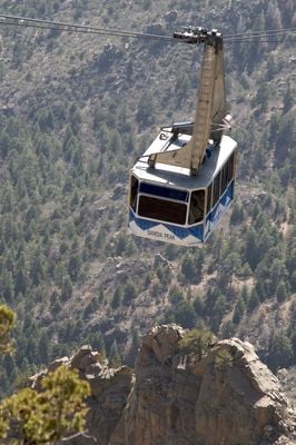
Sandia Peak Tramway, Aerial tramway in Albuquerque, United States.

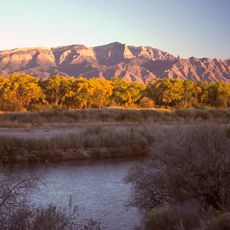
Sandia Peak Tramway is an aerial tramway in Albuquerque that runs from the desert floor to an elevation of 10378 feet (3163 meters), covering a distance of 2.7 miles (4.3 kilometers) across the Sandia Mountains. Two large cabins travel simultaneously on parallel cables and offer an open view of rock formations, forests and the Rio Grande valley during the ride.

Engineering work began in the mid 1960s and required helicopters to transport heavy steel components into rugged terrain. At its opening in 1966 the system became the longest continuous jig-back aerial tramway in North America.

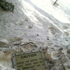
Locals use the gondola year-round for mountain hikes in summer and ski access in winter. On clear days the upper viewing platform draws many families who picnic on the rocks or watch the sunset over the desert.

The cabins run daily with varying schedules depending on the season and hold up to 50 people per trip. The ride takes about 15 minutes and bringing a warm jacket is wise because the temperature at the top is much lower than down in the valley.

During the ride the tramway crosses several climate zones, resulting in a noticeable temperature difference of up to 30 degrees Fahrenheit (17 degrees Celsius). Markers attached to the steel cables help staff monitor the position of the cabins during poor visibility.

The community of curious travelers

AroundUs brings together thousands of curated places, local tips, and hidden gems, enriched daily by 60,000 contributors worldwide.

Start exploring
Location
Old Mexico
GPS coordinates
35.19056,-106.47944
Latest update
December 17, 2025 08:02
Around this place
Sandia Mountains
United States of America

Sandia Mountains

3.5 km
La Luz Trail
United States of America

La Luz Trail

2.6 km
United States of America

Albuquerque Basin

14.9 km
Sandia Cave
United States of America

Sandia Cave

9.8 km
Cliff's Amusement Park
United States of America

Cliff's Amusement Park

11.2 km
Congregation Albert
United States of America

Congregation Albert

10.6 km
United States of America

Tijeras Canyon

14.8 km
New Mexico Rattler
United States of America

New Mexico Rattler

11.2 km
Albuquerque New Mexico Temple
United States of America

Albuquerque New Mexico Temple

4.9 km
Anderson-Abruzzo Albuquerque International Balloon Museum
United States of America

Anderson-Abruzzo Albuquerque International Balloon Museum

10.8 km
Hinkle Family Fun Center
United States of America

Hinkle Family Fun Center

10.7 km
Our Lady of Sorrows Church
United States of America

Our Lady of Sorrows Church

15.2 km
San Ysidro Church
United States of America

San Ysidro Church

13.2 km
Our Lady of Mt. Carmel Church
United States of America

Our Lady of Mt. Carmel Church

12.8 km
United States of America

Hoffmantown Baptist Church

11 km
Tinkertown Museum
United States of America

Tinkertown Museum

10.4 km
Luna Lodge
United States of America

Luna Lodge

14.3 km
Juan Antonio Garcia House
United States of America

Juan Antonio Garcia House

13 km
Congregation B'nai Israel
United States of America

Congregation B'nai Israel

14.4 km
Juan Chavez House
United States of America

Juan Chavez House

14.4 km
San Antonito Church and Cemetery
United States of America

San Antonito Church and Cemetery

12.4 km
Barela–Bledsoe House
United States of America

Barela–Bledsoe House

13.3 km
La Puerta Lodge
United States of America

La Puerta Lodge

14.3 km
Roosevelt School
United States of America

Roosevelt School

14.3 km
Adrian Barela House
United States of America

Adrian Barela House

14.8 km
Felipe Romero House
United States of America

Felipe Romero House

12.9 km
Rumaldo Chavez House
United States of America

Rumaldo Chavez House

11.2 km
Cinemark Rio 24
United States of America

Cinemark Rio 24

12.4 km
Show the full map
« Sandia Peak Tramway - Aerial tramway in Albuquerque, United States » is provided by Around Us (aroundus.com). Images and texts are derived from Wikimedia project under a Creative Commons license. You are allowed to copy, distribute, and modify copies of this page, under the conditions set by the license, as long as this note is clearly visible.

Discover hidden gems everywhere you go!

From secret cafés to breathtaking viewpoints, skip the crowded tourist spots and find places that match your style. Our app makes it easy with voice search, smart filtering, route optimization, and insider tips from travelers worldwide. Download now for the complete mobile experience.

Around Us App Screenshot

A unique approach to discovering new places

Le Figaro

All the places worth exploring

France Info

A tailor-made excursion in just a few clicks

20 Minutes

Around Us
Travel Guide & Maps
Download

Send to your phone

QR Code
1

Open the camera app on your mobile.

2

Point at the QR code with your camera. A notification will appear.

3

Tap the notification to open the link.