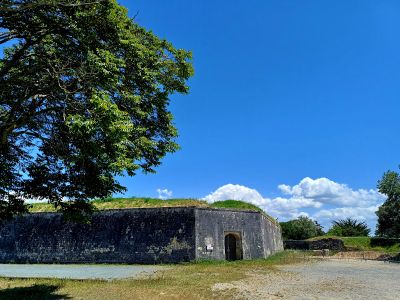
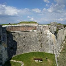
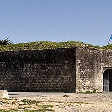
Redoute de Rivedoux, Military fort in Rivedoux-Plage, France
Redoute de Rivedoux is a square fort located on the eastern tip of Île de Ré, surrounded by a dry moat for defense. The structure features thick stone walls with gun emplacements positioned to command views of the coastline.
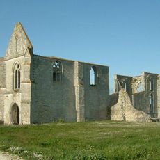
The fort was built in 1674 when King Louis XIV ordered military engineer Vauban to fortify the island following English invasion attempts in the 1600s. It became part of an extensive chain of coastal defenses along France's Atlantic shore.
The fort embodies how France defended its Atlantic coastline during the 17th century through military strategy and strategic placement. It shows the period's concern with protecting island settlements from foreign attack.
The exterior grounds are open to visitors on multiple days each week, though hours vary between weekdays and weekends. Wear comfortable shoes as the terrain is uneven and walking surfaces can be rough.
Inside the fort, a freshwater well provided water for a small garrison during extended sieges, ensuring the defenders could hold out for weeks. The compact design also allowed storage for ammunition and explosive supplies.
Location: Rivedoux-Plage
Address: Chem. des Douves, 17940 Rivedoux-Plage, France
Opening Hours: Monday-Saturday 14:00-16:30; Sunday 09:30-12:30
Phone: +33546098062
Website: http://iledere.com
GPS coordinates: 46.15803,-1.26685
Latest update: December 6, 2025 19:09
The Île de Ré reveals preserved sites beyond its main destinations. The salt marshes of Loix and the Lilleau des Niges Nature Reserve host more than 300 species of migratory birds, while the Baleines Lighthouse offers a view of the Atlantic Ocean. Beaches such as Trousse Chemise and Les Grenettes are characterized by their natural dunes and conditions suitable for water sports. The Fier d'Ars Port maintains its traditional fishing activity with boats and houses with green shutters. The Salt Eco-museum traces the history of salt harvesting and the work of salt workers in the marshes. The Baleines Farm combines agricultural production with shellfish farming near the coast. Villages like Loix offer traditional shops and exhibitions on local customs. These sites reflect the maritime heritage and traditions shaping the island's identity for generations.
Lighthouse at the End of the World
7.1 km
Île de Ré bridge
2.6 km
La Rochelle submarine base
4.4 km
Abbaye Notre-Dame-de-Ré
4 km
Fort de La Prée
3 km
Phare de Chauveau
2.7 km
Sablanceau and Redoute of Rivedoux
637 m
Marché médiéval
5.7 km
Église Sainte-Catherine
5.8 km
Phare du Lavardin
3.2 km
Église de Sainte-Marie-de-Ré
3.5 km
Église Saint-Pierre-de-Laleu
5.1 km
Chapelle Saint-Maurice de La Rochelle
7 km
Hôtel des Durand de la Vaux-Martin
6.9 km
Église Saint-Fort
3.6 km
Église Sainte-Anne de L'Houmeau
7.3 km
Eglise paroissale Sainte-Marie de Ré
3.6 km
Richelieu lighthouse
7.4 km
Musée du Platin
5.6 km
Église Saint-Pierre de Laleu
5.2 km
Plage de Chef de Baie
4.5 km
Temple de Église réformée de France
5.4 km
Église Saint-François de la Pallice
4.1 km
Plage de la Basse Benaie
4.1 km
Abbatiale Notre-Dame-de-Ré dite des Chateliers
3.9 km
Chapelle Saint-Sauveur de Sainte-Marie-de-Ré
4.7 km
Plage de Port Notre-Dame
2.7 km
Ancienne Batterie de Sablanceaux
630 mVisited this place? Tap the stars to rate it and share your experience / photos with the community! Try now! You can cancel it anytime.
Discover hidden gems everywhere you go!
From secret cafés to breathtaking viewpoints, skip the crowded tourist spots and find places that match your style. Our app makes it easy with voice search, smart filtering, route optimization, and insider tips from travelers worldwide. Download now for the complete mobile experience.
A unique approach to discovering new places❞
— Le Figaro
All the places worth exploring❞
— France Info
A tailor-made excursion in just a few clicks❞
— 20 Minutes