Enable Location

We need your location to show you interesting places around you

Discover nearby places

Find interesting locations and hidden gems around you

Precise directions

Get accurate directions and distances to places

Your location is never shared with other users. It's only used when you tap the location button.

The Derry Walls

Log in to your account

Start exploring — it's free

Trusted by 61,346 travelers worldwide

Continue with Google
Continue with Apple
or

We will send you a code to connect

By continuing, you accept our Terms and Conditions and our Privacy Policy

Check your inbox

We've sent a pincode in your inbox. Please enter the code below.

The Derry Walls

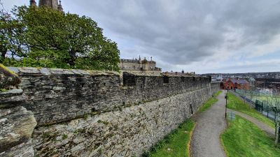
The Derry Walls, Defensive wall in Derry, Northern Ireland.

Description

The Derry Walls form a complete defensive circuit around the old city center, stretching approximately 1.5 km (1 mi) and featuring seven gates with artillery pieces positioned along the ramparts. The structure encloses narrow streets and historic buildings while providing elevated viewpoints across the enclosed area and beyond.

History

The walls were built between 1613 and 1619 by the Irish Society to protect Scottish and English settlers during a period of colonial expansion in the north. They were never successfully breached during later conflicts, which became central to the city's identity and story.

Culture

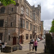
The walls shape how locals and visitors experience the old city today, with people walking the ramparts to see the street layout below and the buildings nestled within. The enclosure creates a distinct community feeling, marking where the oldest part of the city sits apart from modern developments.

Practical

You can walk the entire route on top of the walls, with multiple entry points spread around the perimeter for easy access. The pathways are mostly flat and open, making it accessible for visitors of various abilities.

Did you know?

The walls earned the nickname 'The Maiden City' because they resisted a 105-day siege in 1689 without being breached. This successful defense became a defining moment in the city's memory and remains significant in local identity.

Address
The Diamond, Londonderry BT48 6HW, UK
GPS coordinates
54.99517,-7.32504
Latest update
December 6, 2025 17:44

AroundUs brings together thousands of curated places, local tips, and hidden gems, enriched daily by 60,000 contributors worldwide. Discover all places nearby (United Kingdom).

Explore Northern Ireland amidst Celtic legends, castles, and volcanic landscapes

Northern Ireland tells its story through stones, cliffs, and memories. From the Giant's Causeway to Derry's walls, each place seems filled with stories where Celtic myths, medieval heritage, and traces of the modern world intertwine. Belfast, once an industrial hub turned cultural center, showcases...

« The Derry Walls - Defensive wall in Derry, Northern Ireland » is provided by Around Us (aroundus.com). Images and texts are derived from Wikimedia project under a Creative Commons license. You are allowed to copy, distribute, and modify copies of this page, under the conditions set by the license, as long as this note is clearly visible.

Discover hidden gems everywhere you go!

From secret cafés to breathtaking viewpoints, skip the crowded tourist spots and find places that match your style. Our app makes it easy with voice search, smart filtering, route optimization, and insider tips from travelers worldwide. Download now for the complete mobile experience.

Around Us App Screenshot

A unique approach to discovering new places

Le Figaro

All the places worth exploring

France Info

A tailor-made excursion in just a few clicks

20 Minutes

Around Us
Travel Guide & Maps
Download

Send to your phone

QR Code
1

Open the camera app on your mobile.

2

Point at the QR code with your camera. A notification will appear.

3

Tap the notification to open the link.