高縄の磨崖仏
Location: 桐生市
Website: https://www.city.kiryu.lg.jp/kankou/bunkazai/1010700/shishitei/yuukei/1002050.html
Website: https://city.kiryu.lg.jp/kankou/bunkazai/1010700/shishitei/yuukei/1002050.html
GPS coordinates: 36.43877,139.23069
Latest update: November 14, 2025 23:59
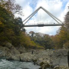
Hanetaki Bridge
4.3 km
Zen Castle
2.1 km
Takei temple ruins
2 km
Wayside shrine
3.1 km
Wayside shrine
2.5 km
Fujiyama Hill
2 km
Fujusawa's Okaku Cheery Tree
3 km
山上多重塔
1.4 km
Observation Hall
1.8 km
船渡し跡地
3.8 km
Scenic viewpoint
4.3 km
わ89-101
4.2 km
Stele, memorial
4.2 km
谷津館
2.6 km
赤城カントリークラブ
3 km
Memorial
3.1 km
膳城 (Ruins of Zen Castle)
2.1 km
Memorial
4.3 km
Memorial
4.3 km
Monument
3.7 km
Wayside shrine
3.7 km
Tomb, tumulus
4.3 km
Tumulus, tomb
4.3 km
わ89-302
4.2 km
Wayside shrine
4.3 km
Wayside shrine
4.3 km
Wayside shrine
6 m
Wayside shrine
3 kmReviews
Visited this place? Tap the stars to rate it and share your experience / photos with the community! Try now! You can cancel it anytime.
Discover hidden gems everywhere you go!
From secret cafés to breathtaking viewpoints, skip the crowded tourist spots and find places that match your style. Our app makes it easy with voice search, smart filtering, route optimization, and insider tips from travelers worldwide. Download now for the complete mobile experience.

A unique approach to discovering new places❞
— Le Figaro
All the places worth exploring❞
— France Info
A tailor-made excursion in just a few clicks❞
— 20 Minutes