Watson Lake Visitor Information Centre
Location: Watson Lake
Opening Hours: Lunedì-Domenica 08:00-20:00
GPS coordinates: 60.06225,-128.71073
Latest update: November 23, 2025 04:01
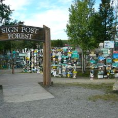
Sign Post Forest
258 m
Tuya Mountains Provincial Park
141.3 km
Caribou Tuya
138.9 km
Smith River Falls – Fort Halkett Provincial Park
137.5 km
Tā Ch’ilā Provincial Park
78.4 km
Hyland River Provincial Park
33.1 km
Coal River Springs Territorial Park
72.8 km
Blue/Dease Rivers Ecological Reserve
36.2 km
Portage Brule Rapids Protected Area
110.9 km
Smith River Ecological Reserve
129.8 km
Mountain Portage Rapids
102.6 km
Portage Brule Rapids Ecological Reserve
111.1 km
Ne'āh' Conservancy
76.7 km
Cranberry Rapids
97.6 km
Stone Island Rapids
96.7 km
Pine Rapids
129.2 km
Portage Brûlé Rapids
111 km
Twomile Rapids
21.5 km
Fourmile Rapids
21.8 km
Cottonwood Rapids
121.7 km
Blue River (British Columbia)
43.4 km
Cassiar Mountains
132.3 km
Two Mile Lake
25.2 km
Tower, Observation tower, scenic viewpoint
37.3 km
Liard river
75.6 km
Viewpoint Beaver dam
79.9 km
Waterfall
116.3 km
Waterfall
131.7 kmReviews
Visited this place? Tap the stars to rate it and share your experience / photos with the community! Try now! You can cancel it anytime.
Discover hidden gems everywhere you go!
From secret cafés to breathtaking viewpoints, skip the crowded tourist spots and find places that match your style. Our app makes it easy with voice search, smart filtering, route optimization, and insider tips from travelers worldwide. Download now for the complete mobile experience.

A unique approach to discovering new places❞
— Le Figaro
All the places worth exploring❞
— France Info
A tailor-made excursion in just a few clicks❞
— 20 Minutes