Tractor
Location: Maryvale
Location: Southern Downs Regional
GPS coordinates: -28.06542,152.24266
Latest update: November 22, 2025 00:30
Main Range National Park
15.2 km
Spicers Gap Road
16.7 km
Yangan Masonic Hall
14.9 km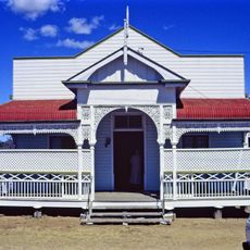
Yangan School of Arts
15 km
Mount Dumaresq Conservation Park
8.1 km
Goomburra State Forest
16.3 km
Spicers Gap State Forest
15.2 km
Scenic viewpoint
15.2 km
Scenic viewpoint
15.1 km
Manna Gum camping area Main Range NP
13.9 km
Poplar Flat camping area Main Range NP
13.8 km
Poplar Flat camping area Main Range NP
13.7 km
Tardis
13.7 km
Global Warming
12.4 km
Janowen Hills 4WD Park
7.8 km
Bare Rock
14.7 km
Mount Cordeaux Lookout
15.1 km
Scenic viewpoint
14.9 km
Old Logging Cart
17 km
Auracaria Falls
16.6 km
Commander Lookout
6.8 km
Scenic viewpoint
15.2 km
Memorial
15 km
Traditional Australian Slab Cabin
13.7 km
Explorer Allan Cunningham and the Darling Downs
5.6 km
Cascade Falls
14.8 km
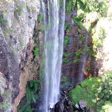
Waterfall
16.5 km
Waterfall
16.6 kmReviews
Visited this place? Tap the stars to rate it and share your experience / photos with the community! Try now! You can cancel it anytime.
Discover hidden gems everywhere you go!
From secret cafés to breathtaking viewpoints, skip the crowded tourist spots and find places that match your style. Our app makes it easy with voice search, smart filtering, route optimization, and insider tips from travelers worldwide. Download now for the complete mobile experience.

A unique approach to discovering new places❞
— Le Figaro
All the places worth exploring❞
— France Info
A tailor-made excursion in just a few clicks❞
— 20 Minutes