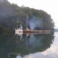
Helford River

Log in to your account

AroundUs is a community-driven map of interesting places, built by curious explorers like you. It grows with every review, story, and photo you share.
Connect to save your favorite spots, contribute locations, and create personalized routes.
Continue with Google
Continue with Apple
Continue with X
Continue with Facebook
Continue with email
By continuing, you accept our Terms and Conditions and our Privacy Policy
Create an account

Helford River

Add to collection
Map
Suggest a change
Share

Helford River

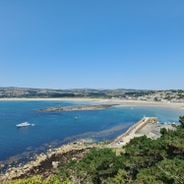
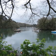
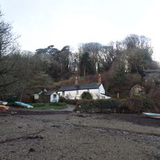
The Helford River is a waterway on Cornwall's south coast bordered by dense woodlands and tiny villages, stretching between Falmouth Bay and the Lizard Peninsula. It contains several creeks and hidden inlets marked by steep, tree-covered banks that shelter herons, egrets, and waterfowl.

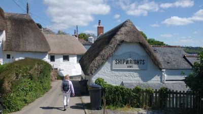
The Helford River was once a busy trading port where ships brought lace, granite, tobacco, and French rum before becoming the quiet place it is today. Small ferries have carried people across the water for hundreds of years and remain part of the area's long maritime and fishing heritage.

The Helford River features prominently in Daphne du Maurier's novel Frenchman's Creek, which centers on one of its creeks and shapes how visitors understand this place. Today, walkers and readers explore the same quiet waters that inspired the author's imagination.

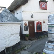
Visitors can explore the area on foot with easy to moderate walks along the coast, or by boat to reach hidden creeks. Kayaks, paddleboards, and small boats are available at several points along the river, and many pubs and cafés near the water offer places to rest.

The area is home to the Sea Life Trust Seal Sanctuary near Gweek, where injured seals are cared for and released back into the wild. Visitors can watch seal pups through underwater windows and learn about their rescue stories.

Address: Helford River, United Kingdom

GPS coordinates: 50.09773,-5.15303

Latest update: January 8, 2026 16:41

Photos
What to see in Cornwall: castles, coastal villages, beaches and gardens

Cornwall lies at the southwestern tip of England. It is a peninsula surrounded by the sea, shaping its history and identity. You can see this region through its castles on cliffs like Tintagel or St Michael's Mount, its fishing villages on small bays such as Mousehole, and its busy ports like...

Around this place
Port Navas Creek
United Kingdom

Port Navas Creek

935 m
United Kingdom

The Cottage

1.2 km
The Shipwright's Arms Public House
United Kingdom

The Shipwright's Arms Public House

1.3 km
United Kingdom

Chestnut Cottage

1.2 km
United Kingdom

Loloma Cottage

1.3 km
United Kingdom

Rose Cottage

1.3 km
Tremayne Quay
United Kingdom

Tremayne Quay

1.3 km
United Kingdom

Popigale

1.3 km
United Kingdom

Mimosa Cottage

1.3 km
United Kingdom

Well Too And Well House

1.4 km
United Kingdom

Round 600yds (550m) WNW of Helford

802 m
United Kingdom

Port Navas Quay

1.3 km
United Kingdom

Tremorna

1.3 km
United Kingdom

Lower Calamansack Farmhouse Including Backyard Wall To North West

279 m
United Kingdom

Former Reading Room And Wash House

1.2 km
United Kingdom

Terrace Retaining Wall, Privy And Cess Pit Immediately South East Of Lower Calamansack Farmhouse And Lower Calamansack Cottage

267 m
United Kingdom

Quay At The Foreshore Of The Shipwrights Arms Public House

1.3 km
United Kingdom

Quay At Sw 747 263

495 m
United Kingdom

Quay And Ramp Approximately 250 Metres South West Of Lower Calamansack

474 m
Penarvon Cove
United Kingdom

Penarvon Cove

1.1 km
United Kingdom

Point Cottage And Garden Wall To The East

1.3 km
United Kingdom

Building At Approximately 5 Metres West Of The Shipwrights Arms Public House

1.3 km
United Kingdom

Rose Cottage at SW 758 262

1.3 km
United Kingdom

Cottage Occupied By Mrs Westlake At Sw 7530 2755 Including Front Garden Wall And Gate Piers

1.3 km
United Kingdom

Building At Approx 3M North East Of The Shipwrights Arms Public House And Including Wall To East

1.3 km
United Kingdom

Garden Walls Immediately To South East Of Lower Calamansack Farmhouse

241 m
United Kingdom

The Bar (sand & shingle) tidal area

1.3 km
United Kingdom

Lower Calamansack Cottage

268 m
Show the full map
Reviews

Visited this place? Tap the stars to rate it and share your experience / photos with the community! Try now! You can cancel it anytime.

« Helford River » is provided by Around Us (aroundus.com). Images and texts are derived from Wikimedia project under a Creative Commons license. You are allowed to copy, distribute, and modify copies of this page, under the conditions set by the license, as long as this note is clearly visible.

Discover hidden gems everywhere you go!

From secret cafés to breathtaking viewpoints, skip the crowded tourist spots and find places that match your style. Our app makes it easy with voice search, smart filtering, route optimization, and insider tips from travelers worldwide. Download now for the complete mobile experience.

Around Us App Screenshot

A unique approach to discovering new places

Le Figaro

All the places worth exploring

France Info

A tailor-made excursion in just a few clicks

20 Minutes