Enable Location

We need your location to show you interesting places around you

Discover nearby places

Find interesting locations and hidden gems around you

Precise directions

Get accurate directions and distances to places

Your location is never shared with other users. It's only used when you tap the location button.

Kunčický bludný balvan

Log in to your account

Start exploring — it's free

Trusted by 63,494 travelers worldwide

Continue with Google
Continue with Apple
or

We will send you a code to connect

By continuing, you accept our Terms and Conditions and our Privacy Policy

Check your inbox

We've sent a pincode in your inbox. Please enter the code below.

Kunčický bludný balvan
Discussion Reviews 1 Photos
2k Popularity

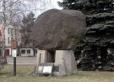
Kunčický bludný balvan, Natural monument in Kunčice, Czech Republic

Kunčický Findling is a large granite boulder composed of coarse-grained rock with yellow-gray and pink tones throughout its surface. It measures approximately 3 by 2.5 by 1.5 meters and weighs around 17 tons.

Workers discovered this granite boulder in 1954 during foundation work at a local foundry. The find led to its protection and designation as a geological monument.

The boulder represents a tangible connection to the Ice Age, showing how glaciers moved massive rocks across the landscape. Today, the site offers a direct way to understand the geological forces that shaped this region.

The boulder is located near the southern entrance of a former foundry complex that is accessible by public transport. The site has a relatively flat layout that makes reaching the stone straightforward.

This is one of the largest known erratic boulders in the Czech Republic and owes its preservation to a chance discovery during construction work. The exact source of the granite and the distance it traveled during the Ice Age remain partly mysterious.

The community of curious travelers

AroundUs brings together thousands of curated places, local tips, and hidden gems, enriched daily by 60,000 contributors worldwide.

Start exploring
Location
Inception
January 1, 1990
GPS coordinates
49.79231,18.29897
Latest update
December 14, 2025 11:04
Around this place
Mine Jeremenko
Czech Republic

Mine Jeremenko

2.4 km
Church of Saint Catherine
Czech Republic

Church of Saint Catherine

2.4 km
Husův sbor
Czech Republic

Husův sbor

2.3 km
Důl Alexander
Czech Republic

Důl Alexander

2.1 km
Kostel Panny Marie, královny posvátného růžence
Czech Republic

Kostel Panny Marie, královny posvátného růžence

2.2 km
Hrabovjanka
Czech Republic

Hrabovjanka

1.7 km
Naučná stezka hrabovského rodáka, básníka a spisovatele Viléma Závady
Czech Republic

Naučná stezka hrabovského rodáka, básníka a spisovatele Viléma Závady

2.4 km
Dub vzpomínkový
Czech Republic

Dub vzpomínkový

1.8 km
Pomník obětem 1. světové války, Vratimov
Czech Republic

Pomník obětem 1. světové války, Vratimov

2.3 km
Dub tolerance
Czech Republic

Dub tolerance

2.7 km
Energetická substance
Czech Republic

Energetická substance

2.8 km
Obloukový železniční most Kunčice - Vítkovice
Czech Republic

Obloukový železniční most Kunčice - Vítkovice

1.7 km
Pomník a společný hrob horníků zastřelených při stávce v roce 1890
Czech Republic

Pomník a společný hrob horníků zastřelených při stávce v roce 1890

2.6 km
Most trati Nová huť – Vítkovické železárny přes trať Kunčice - Kunčičky
Czech Republic

Most trati Nová huť – Vítkovické železárny přes trať Kunčice - Kunčičky

1 km
Cross at the Church of St. John the Baptist in Vratimov
Czech Republic

Cross at the Church of St. John the Baptist in Vratimov

2 km
World War II memorial in Hrabůvka
Czech Republic

World War II memorial in Hrabůvka

2.7 km
Komorní klub
Czech Republic

Komorní klub

2.7 km
Hrob obětí zastřelených při hladových demonstracích v roce 1917
Czech Republic

Hrob obětí zastřelených při hladových demonstracích v roce 1917

2.6 km
Zaopatřovací ústav
Czech Republic

Zaopatřovací ústav

2.7 km
Vybavení jámy Louis
Czech Republic

Vybavení jámy Louis

2.4 km
Church of St. John the Baptist in Vratimov
Czech Republic

Church of St. John the Baptist in Vratimov

1.9 km
Jubilejní 31
Czech Republic

Jubilejní 31

2.7 km
Torzo mostu přes Ostravici nad jezem Kunčičky
Czech Republic

Torzo mostu přes Ostravici nad jezem Kunčičky

2 km
Jubilejní 33
Czech Republic

Jubilejní 33

2.7 km
Jubilejní 37
Czech Republic

Jubilejní 37

2.8 km
Jubilejní 43
Czech Republic

Jubilejní 43

2.8 km
Footbridge of Ostrava-Kunčice station
Czech Republic

Footbridge of Ostrava-Kunčice station

579 m
Most železniční vlečky Kunčice - Vítkovice
Czech Republic

Most železniční vlečky Kunčice - Vítkovice

1.7 km
Show the full map
Reviews
Share your experience

No review yet

Discussions
Start a discussion...

No discussion yet

« Kunčický bludný balvan - Natural monument in Kunčice, Czech Republic » is provided by Around Us (aroundus.com). Images and texts are derived from Wikimedia project under a Creative Commons license. You are allowed to copy, distribute, and modify copies of this page, under the conditions set by the license, as long as this note is clearly visible.

Discover hidden gems everywhere you go!

From secret cafés to breathtaking viewpoints, skip the crowded tourist spots and find places that match your style. Our app makes it easy with voice search, smart filtering, route optimization, and insider tips from travelers worldwide. Download now for the complete mobile experience.

Around Us App Screenshot

A unique approach to discovering new places

Le Figaro

All the places worth exploring

France Info

A tailor-made excursion in just a few clicks

20 Minutes

Around Us
Travel Guide & Maps
Download

Send to your phone

QR Code
1

Open the camera app on your mobile.

2

Point at the QR code with your camera. A notification will appear.

3

Tap the notification to open the link.