Křovina Sněžné-Samotín, Mountain summit in Bohemian-Moravian Highlands, Czech Republic.
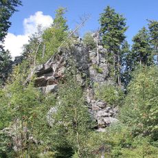
Křovina is a forested summit of 830 m in the Devítiskalská vrchovina, the second-highest peak of the Žďárské vrchy, on the cadastral territory of Samotín in the Vysočina Region. Its top, marked by a granite triangulation post at 829.68 m, lies about 160 m south of a forest path and has no view.
The name Křovina is a standardized oronym registered by the Czech Office for Surveying, Mapping and Cadastre. The summit carries a measured trigonometric point, Křovina, with a levelled height of 829.68 m (triangulation sheet 3316, point 37), marked by a granite post in the forest about 160 m south of the forest path between the saddles below Lisovská skála and the Suchý kopec ridge.
The name Křovina is a standardized Czech oronym for the wooded hill and its summit, recorded by the Czech Office for Surveying, Mapping and Cadastre. A red-marked KČT trail runs through the summit section between the Pod Lisovskou skálou and Malinská skála signposts.
The summit lies off the marked red trail between Pod Lisovskou skálou and Malinská skála; the trig point and a small stone cairn sit about 160 m south of the path on a forest track. There is no view from the wooded top. An unmarked forest road also climbs from the Blatka saddle, reached via cycle route 4022 toward Milovy.
The summit lies about 160 m south of the red-marked trail between Pod Lisovskou skálou and Malinská skála, off the marked path and without a view. A small piled stone cairn marks the spot beside the granite boundary post of the trigonometric point Křovina, at 829.68 m.
The community of curious travelers
AroundUs brings together thousands of curated places, local tips, and hidden gems, enriched daily by 94,497 contributors worldwide.