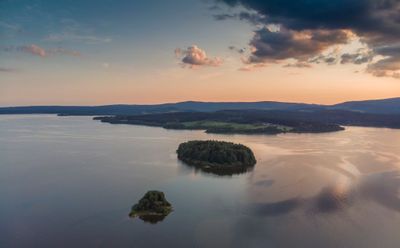
Tajvan, Lake island in Horní Planá, Czech Republic.
Tajvan is a forested lake island in the Lipno Reservoir that rises approximately 737 meters above sea level. The island is covered with mixed pine and birch woodlands that create a natural habitat for wildlife found throughout the reservoir area.
The island was named by local fishermen who gave it a designation connected to a distinctive individual from the area. This naming reflects the strong link between the island and fishing activities that were long practiced in this region.
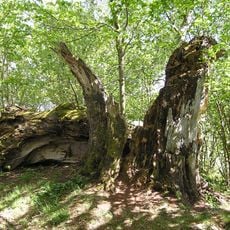
The forested landscape of the island represents the natural heritage of South Bohemia, where outdoor activities connect visitors with regional traditions.
The island can be viewed from the shores of the reservoir and offers views across the water and surrounding landscape. Visitors should expect uneven terrain and bring appropriate gear for exploring the forested areas.
The island is the largest in the reservoir and offers rare opportunities to observe waterfowl and other species that live there. This undisturbed natural area attracts birdwatchers and nature enthusiasts who wish to study the local animal life.
Location: Horní Planá
Elevation above the sea: 737 m
GPS coordinates: 48.74167,14.06278
Latest update: December 14, 2025 11:25
Church of Saint Margaret in Horní Planá
3.7 km
Stifter-Buche
2.6 km
Stifterův smrk
3.3 km
Železniční most přes potok Olšinu u Olšova
3.9 km
Most silnice I/39 přes Černý potok v Černé v Pošumaví
3.6 km
Socha svatého Jana Nepomuckého
3.6 km
Wo-man
3.1 km
Pomník obětem pochodu smrti v dolní části náměstí v Horní Plané
3.6 km
Socha svatého Jana Nepomuckého
3.5 km
Church of the Immaculate Conception
3.6 km
Rectory in Horní Planá
3.7 km
Boží muka u Jenišova
2 km
Kašna II.
3.6 km
World War I memorial in Černá v Pošumaví
3.6 km
Kašna I.
3.6 km
Rodný dům Adalberta Stiftera
3.4 km
Pomník padlým v I. sv. válce v horní části náměstí v Horní Plané
3.7 km
Kaplička
3.3 km
Fetzlova kaplička jižně od Černé v Pošumaví
3.5 km
Lípa Radslav
3 km
Socha v Černé v Pošumaví
3.6 km
Sloup v horní části náměstí v Horní Plané
3.7 km
Boží muka u jižní strany kostela sv. Markéty v Horní Plané
3.7 km
Kříž v Černé v Pošumaví
2.7 km
Kříž na silnici Bližná - Černá v Pošumaví
3.4 km
Pomník obětem 1. světové války v Černé v Pošumaví
3.6 km
Plastika v Černé v Pošumaví
3.6 km
Výklenková kaplička v Černé v Pošumaví
3.6 kmVisited this place? Tap the stars to rate it and share your experience / photos with the community! Try now! You can cancel it anytime.
Discover hidden gems everywhere you go!
From secret cafés to breathtaking viewpoints, skip the crowded tourist spots and find places that match your style. Our app makes it easy with voice search, smart filtering, route optimization, and insider tips from travelers worldwide. Download now for the complete mobile experience.
A unique approach to discovering new places❞
— Le Figaro
All the places worth exploring❞
— France Info
A tailor-made excursion in just a few clicks❞
— 20 Minutes