Enable Location

We need your location to show you interesting places around you

Discover nearby places

Find interesting locations and hidden gems around you

Precise directions

Get accurate directions and distances to places

Your location is never shared with other users. It's only used when you tap the location button.

Log in to your account

Start exploring — it's free

Trusted by 63,637 travelers worldwide

Continue with Google
Continue with Apple
or

We will send you a code to connect

By continuing, you accept our Terms and Conditions and our Privacy Policy

Check your inbox

We've sent a pincode in your inbox. Please enter the code below.

Městské skály
Discussion Reviews Photo
2.1k Popularity

Městské skály, Rock formation near Šumperk, Czech Republic

Městské skály is a rock formation featuring cliffs and towers made of light-colored pegmatite near Šumperk. The structure rises to an elevation of 675 meters and displays varied geological layers that create a distinctive visual character.

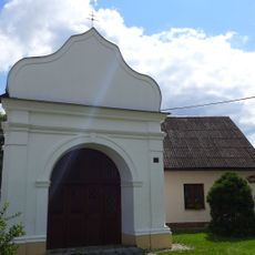
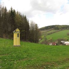
The formation developed through geological processes over millions of years and later became an important landmark for people exploring the region. Since early tourism times, it has served as a favored destination for those seeking outdoor experiences.

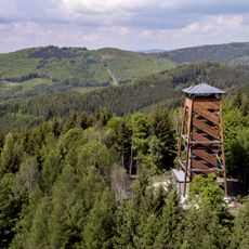
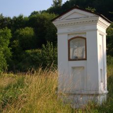
The wooden pavilion at the summit serves as a gathering place where visitors pause to rest and take in the views. Local people regularly visit this spot to spend time outdoors and enjoy the landscape stretching across the valleys below.

A marked green hiking trail connects the Šumperk train station to the rock formation and takes around 2-3 hours to complete. The path is well-marked and popular on weekends, so sturdy footwear and water are advisable for the journey.

In certain areas the rock transitions from pegmatite to gneiss and phyllite, creating diverse climbing terrain that attracts experienced climbers. This geological variety in a compact space makes the site interesting for those interested in different rock types.

The community of curious travelers

AroundUs brings together thousands of curated places, local tips, and hidden gems, enriched daily by 60,000 contributors worldwide.

Start exploring
Location
GPS coordinates
50.01158,16.97787
Latest update
December 14, 2025 09:45
Around this place
Bukovka
Czech Republic

Bukovka

2.6 km
Czech Republic

Šumperk

2.6 km
All Saints church
Czech Republic

All Saints church

2.2 km
Kostel svatého Michala
Czech Republic

Kostel svatého Michala

1.7 km
Church of the Assumption of the Virgin Mary (Rapotín)
Czech Republic

Church of the Assumption of the Virgin Mary (Rapotín)

3.3 km
Boží muka
Czech Republic

Boží muka

2.1 km
Memorial of fascism victims Bratrušovská střelnice
Czech Republic

Memorial of fascism victims Bratrušovská střelnice

2.8 km
Pomník v Rapotíně na Náměstí Svobody
Czech Republic

Pomník v Rapotíně na Náměstí Svobody

3.3 km
Column shrine in Rapotín
Czech Republic

Column shrine in Rapotín

3.5 km
Pomník v Šumperku na Reissově ulici
Czech Republic

Pomník v Šumperku na Reissově ulici

3.7 km
Pomník v Šumperku v parku U Sanatoria
Czech Republic

Pomník v Šumperku v parku U Sanatoria

3.5 km
Kaplička v Petrově nad Desnou u hřbitova
Czech Republic

Kaplička v Petrově nad Desnou u hřbitova

3.5 km
Sloup se sochou Panny Marie v Rapotíně u kostela
Czech Republic

Sloup se sochou Panny Marie v Rapotíně u kostela

3.3 km
Chapel of Saint Michael in Rapotín
Czech Republic

Chapel of Saint Michael in Rapotín

3.4 km
Pomník padlým v Rapotíně na zdi kostela
Czech Republic

Pomník padlým v Rapotíně na zdi kostela

3.3 km
Kříž v Rapotíně na Jesenické ulici
Czech Republic

Kříž v Rapotíně na Jesenické ulici

3.2 km
Kříž na okraji Rejchartic u silnice
Czech Republic

Kříž na okraji Rejchartic u silnice

2.5 km
Kaple v Rapotíně na ulici Družstevní
Czech Republic

Kaple v Rapotíně na ulici Družstevní

3.3 km
Boží muka u Šumperka v Nových Domkách
Czech Republic

Boží muka u Šumperka v Nových Domkách

3.1 km
Pomník padlým v Rejcharticích
Czech Republic

Pomník padlým v Rejcharticích

1.8 km
Pomník padlým v Bratrušově
Czech Republic

Pomník padlým v Bratrušově

2.1 km
Kaplička v Rapotíně v ulici U Losinky
Czech Republic

Kaplička v Rapotíně v ulici U Losinky

3.2 km
Kaplička v Rejcharticích poblíž kostela ve stráni
Czech Republic

Kaplička v Rejcharticích poblíž kostela ve stráni

1.7 km
Boží muka u vchodu do kostela sv. Michala v Rejcharticích
Czech Republic

Boží muka u vchodu do kostela sv. Michala v Rejcharticích

1.7 km
Kříž v Rapotíně před kostelem
Czech Republic

Kříž v Rapotíně před kostelem

3.3 km
Hromadný hrob severně od Šumperku
Czech Republic

Hromadný hrob severně od Šumperku

2.2 km
Kaplička v Kopřivné na jižním okraji
Czech Republic

Kaplička v Kopřivné na jižním okraji

3.5 km
Kaple v Osikově na východním okraji
Czech Republic

Kaple v Osikově na východním okraji

1.9 km
Show the full map
Reviews
Share your experience

No review yet

Discussions
Start a discussion...

No discussion yet

« Městské skály - Rock formation near Šumperk, Czech Republic » is provided by Around Us (aroundus.com). Images and texts are derived from Wikimedia project under a Creative Commons license. You are allowed to copy, distribute, and modify copies of this page, under the conditions set by the license, as long as this note is clearly visible.

Discover hidden gems everywhere you go!

From secret cafés to breathtaking viewpoints, skip the crowded tourist spots and find places that match your style. Our app makes it easy with voice search, smart filtering, route optimization, and insider tips from travelers worldwide. Download now for the complete mobile experience.

Around Us App Screenshot

A unique approach to discovering new places

Le Figaro

All the places worth exploring

France Info

A tailor-made excursion in just a few clicks

20 Minutes

Around Us
Travel Guide & Maps
Download

Send to your phone

QR Code
1

Open the camera app on your mobile.

2

Point at the QR code with your camera. A notification will appear.

3

Tap the notification to open the link.