Enable Location

We need your location to show you interesting places around you

Discover nearby places

Find interesting locations and hidden gems around you

Precise directions

Get accurate directions and distances to places

Your location is never shared with other users. It's only used when you tap the location button.

Třípanský sloup

Log in to your account

Start exploring — it's free

Trusted by 62,285 travelers worldwide

Continue with Google
Continue with Apple
or

We will send you a code to connect

By continuing, you accept our Terms and Conditions and our Privacy Policy

Check your inbox

We've sent a pincode in your inbox. Please enter the code below.

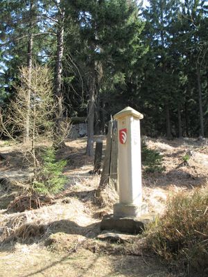
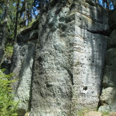
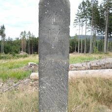
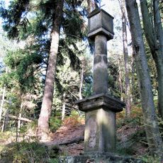
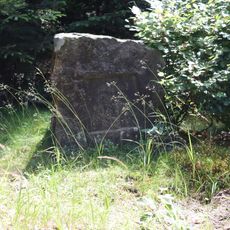
Třípanský sloup, Boundary marker column at Rozhled, Czech Republic.

The Třípanský sloup is a boundary column erected where three historical domains met. Built from millstone granite on a sandstone base, it stands about two meters tall with carved coats of arms set into its triangular top section.

This column was erected in 1705 to replace an earlier boundary marker known as the Red Column that had marked disputed territory borders. The monument dates from an era when stone columns were the primary method for visibly marking territorial divisions between ruling domains.

This column shows how people once marked territorial boundaries by erecting carved stone monuments. The three coats of arms at the top represent the three domains that met at this exact location.

Visitors can reach the monument by taking a train to Jedlová station and then following marked hiking trails through the surrounding countryside. The location is accessible on foot and serves as a good starting point for exploring the wider landscape in the area.

The original monument was stolen in 1999, but stonemason Jan Pokorný created a replica of the historic column in 2016. This reconstruction allows visitors today to see the monument as it originally stood.

The community of curious travelers

AroundUs brings together thousands of curated places, local tips, and hidden gems, enriched daily by 60,000 contributors worldwide.

Start exploring
Location
Part of
political border
GPS coordinates
50.83919,14.57549
Latest update
December 14, 2025 17:44
« Třípanský sloup - Boundary marker column at Rozhled, Czech Republic » is provided by Around Us (aroundus.com). Images and texts are derived from Wikimedia project under a Creative Commons license. You are allowed to copy, distribute, and modify copies of this page, under the conditions set by the license, as long as this note is clearly visible.

Discover hidden gems everywhere you go!

From secret cafés to breathtaking viewpoints, skip the crowded tourist spots and find places that match your style. Our app makes it easy with voice search, smart filtering, route optimization, and insider tips from travelers worldwide. Download now for the complete mobile experience.

Around Us App Screenshot

A unique approach to discovering new places

Le Figaro

All the places worth exploring

France Info

A tailor-made excursion in just a few clicks

20 Minutes

Around Us
Travel Guide & Maps
Download

Send to your phone

QR Code
1

Open the camera app on your mobile.

2

Point at the QR code with your camera. A notification will appear.

3

Tap the notification to open the link.