Fort Wyman, Civil War fortification in Rolla, United States
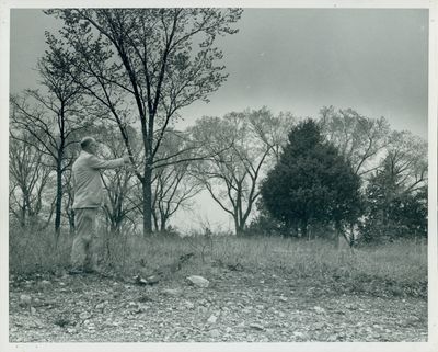
Fort Wyman was a rectangular earthen fortification located on a hill along Highway 63, designed with a dry moat and strategic gun positions at each corner. The structure provided good sight lines over the surrounding terrain and controlled access to the railroad terminus.
After the Union defeat at Wilson's Creek in August 1861, Union forces built this fortification to secure the railroad line and maintain their position in the region. It served as a supply depot throughout the war years and remained an important Union stronghold in Missouri.
The fort served as a visible symbol of Union military control in the region, with soldiers regularly moving through the surrounding area. Local residents experienced the constant military presence as part of daily life during the conflict.
The hilltop location provides good visibility of the surrounding area and the site is accessible from Highway 63. Visitors should be prepared for open terrain and changing weather conditions throughout the year.
Each of the four heavy cannons required ten mules to transport them from the railroad depot to their positions at the fort's corners. This logistical challenge reveals how difficult it was to supply and maintain such military installations during wartime.
The community of curious travelers
AroundUs brings together thousands of curated places, local tips, and hidden gems, enriched daily by 60,000 contributors worldwide.