Enable Location

We need your location to show you interesting places around you

Discover nearby places

Find interesting locations and hidden gems around you

Precise directions

Get accurate directions and distances to places

Your location is never shared with other users. It's only used when you tap the location button.

Murray's Mill Historic District

Log in to your account

Start exploring — it's free

Trusted by 61,787 travelers worldwide

Continue with Google
Continue with Apple
or

We will send you a code to connect

By continuing, you accept our Terms and Conditions and our Privacy Policy

Check your inbox

We've sent a pincode in your inbox. Please enter the code below.

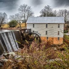
Murray's Mill Historic District, Mill complex in Catawba County, North Carolina.

Description

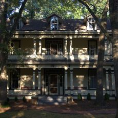
Murray's Mill Historic District is a mill complex in Catawba County featuring over 20 buildings dating from the 1880s to mid-20th century, including a two-story mill building, worker and family residences, and support structures. The property spreads across more than 150 acres and displays a complete working grain-milling operation with its associated living quarters.

History

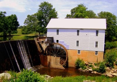
William Murray established the original mill, and his son John built the current mill structure in 1913 to replace the earlier operation. The installation of a 22-foot overshot waterwheel and later a Eureka roller mill system demonstrate the technological improvements the family invested in over time.

Culture

The mill operated as a gathering place where local farmers brought grain and shared news with each other. The arrangement of buildings across the property reflects how closely the Murray family worked alongside their employees and neighbors.

Practical

The site is accessible Thursday through Friday from June to September and on weekends from March to November. Guided tours explain the traditional milling processes and how water power operated the machinery.

Did you know?

Inside the mill building, original French buhr millstones weighing one ton each are still in place, showing how heavy and durable the equipment had to be. These massive stones are visible as you walk through the historic spaces where grain was processed the same way over a century ago.

Location
GPS coordinates
35.67420,-81.09560
Latest update
December 14, 2025 14:22

AroundUs brings together thousands of curated places, local tips, and hidden gems, enriched daily by 60,000 contributors worldwide. Discover all places nearby (North Carolina).

Around this place
Lake Norman State Park
United States of America

Lake Norman State Park

14 km
Bunker Hill Covered Bridge
United States of America

Bunker Hill Covered Bridge

5.6 km
Balls Creek Campground
United States of America

Balls Creek Campground

5 km
Catawba County Courthouse
United States of America

Catawba County Courthouse

11.5 km
Johnson-Neel House
United States of America

Johnson-Neel House

20.9 km
Iredell County Courthouse
United States of America

Iredell County Courthouse

22.3 km
Congregation Emanuel
United States of America

Congregation Emanuel

22.2 km
Shuford House
United States of America

Shuford House

22.7 km
St. Philip's Roman Catholic Church
United States of America

St. Philip's Roman Catholic Church

21.7 km
St. John's Lutheran Church
United States of America

St. John's Lutheran Church

10.3 km
Academy Hill Historic District
United States of America

Academy Hill Historic District

21.8 km
Morrison-Mott House
United States of America

Morrison-Mott House

22.5 km
Kenworth Historic District
United States of America

Kenworth Historic District

21.9 km
St. Paul's Reformed Church
United States of America

St. Paul's Reformed Church

15.9 km
Center Street A.M.E. Zion Church
United States of America

Center Street A.M.E. Zion Church

22.3 km
United States Post Office and County Courthouse
United States of America

United States Post Office and County Courthouse

22.4 km
Grace Reformed Church
United States of America

Grace Reformed Church

11.6 km
Col. Silas Alexander Sharpe House
United States of America

Col. Silas Alexander Sharpe House

22.3 km
Murray's Mill Historic Site
United States of America

Murray's Mill Historic Site

269 m
Main Building, Mitchell College
United States of America

Main Building, Mitchell College

21.8 km
Newton Downtown Historic District
United States of America

Newton Downtown Historic District

11.4 km
Bost-Burris House
United States of America

Bost-Burris House

13.9 km
South Race Street Historic District
United States of America

South Race Street Historic District

21.1 km
Abraham Anthony Farm
United States of America

Abraham Anthony Farm

22.4 km
Statesville Commercial Historic District
United States of America

Statesville Commercial Historic District

21.1 km
Foil–Cline House
United States of America

Foil–Cline House

11.8 km
McElwee Houses
United States of America

McElwee Houses

22.6 km
North Carolina Route 1006 Bridge
United States of America

North Carolina Route 1006 Bridge

9.1 km
Show the full map
« Murray's Mill Historic District - Mill complex in Catawba County, North Carolina » is provided by Around Us (aroundus.com). Images and texts are derived from Wikimedia project under a Creative Commons license. You are allowed to copy, distribute, and modify copies of this page, under the conditions set by the license, as long as this note is clearly visible.

Discover hidden gems everywhere you go!

From secret cafés to breathtaking viewpoints, skip the crowded tourist spots and find places that match your style. Our app makes it easy with voice search, smart filtering, route optimization, and insider tips from travelers worldwide. Download now for the complete mobile experience.

Around Us App Screenshot

A unique approach to discovering new places

Le Figaro

All the places worth exploring

France Info

A tailor-made excursion in just a few clicks

20 Minutes

Around Us
Travel Guide & Maps
Download

Send to your phone

QR Code
1

Open the camera app on your mobile.

2

Point at the QR code with your camera. A notification will appear.

3

Tap the notification to open the link.