Bunker Hill Covered Bridge

Log in to your account

AroundUs is a community-driven map of interesting places, built by curious explorers like you. It grows with every review, story, and photo you share.
Connect to save your favorite spots, contribute locations, and create personalized routes.
Continue with Google
Continue with Apple
Continue with X
Continue with Facebook
Continue with email
By continuing, you accept our Terms and Conditions and our Privacy Policy
Create an account
Add to collection
Map
Suggest a change
Share

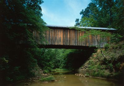
Bunker Hill Covered Bridge, Covered bridge in Claremont, United States.

Bunker Hill Covered Bridge is a wooden crossing that spans Lyle Creek with a tin-shingled roof and Haupt truss structural design. The structure displays the characteristic form of a covered passageway with traditional timber framing and support elements.

Construction took place in 1895 by builder Andrew Loretz Ramsour on what was previously a Native American footpath known as Island Ford Road. The bridge was erected during a period when covered crossings were still commonly built with traditional timber techniques in this region.

The bridge reflects rural American construction methods from the late 1800s, with its timber framing and design choices showing how people built practical structures for everyday crossings. Today it demonstrates the craftsmanship and engineering knowledge that existed in this region during that era.

The location sits in Connor Park alongside US Highway 70 with free parking available for visitors. Self-guided exploration is possible, allowing you to view the structure from different angles and take in the surrounding setting.

This bridge is one of only two remaining covered bridges in North Carolina and houses the last known wooden Haupt truss design in the United States. The structural approach is rare and makes this location an important example of a nearly forgotten building technique.

Location: North Carolina

GPS coordinates: 35.72150,-81.11520

Latest update: December 11, 2025 18:09

Photos
Around this place
Lake Norman State Park
United States of America

Lake Norman State Park

16.8 km
Balls Creek Campground
United States of America

Balls Creek Campground

10.4 km
Hightower Hall
United States of America

Hightower Hall

18.7 km
Murray's Mill Historic District
United States of America

Murray's Mill Historic District

5.6 km
Claremont High School Historic District
United States of America

Claremont High School Historic District

20.8 km
Catawba County Courthouse
United States of America

Catawba County Courthouse

11.6 km
Shuford House
United States of America

Shuford House

19.8 km
St. Philip's Roman Catholic Church
United States of America

St. Philip's Roman Catholic Church

20.9 km
St. John's Lutheran Church
United States of America

St. John's Lutheran Church

6.4 km
First Presbyterian Church
United States of America

First Presbyterian Church

20.4 km
Oakwood Historic District
United States of America

Oakwood Historic District

20.9 km
Hickory Municipal Building
United States of America

Hickory Municipal Building

20.6 km
Kenworth Historic District
United States of America

Kenworth Historic District

19.4 km
St. Paul's Reformed Church
United States of America

St. Paul's Reformed Church

16.1 km
Elliott–Carnegie Library
United States of America

Elliott–Carnegie Library

20.8 km
Dr. Glenn R. Frye House
United States of America

Dr. Glenn R. Frye House

20.3 km
Clement Geitner House
United States of America

Clement Geitner House

20.9 km
Grace Reformed Church
United States of America

Grace Reformed Church

11.8 km
Lee & Helen George House
United States of America

Lee & Helen George House

20.2 km
Hickory Southwest Downtown Historic District
United States of America

Hickory Southwest Downtown Historic District

20.4 km
Murray's Mill Historic Site
United States of America

Murray's Mill Historic Site

5.4 km
Newton Downtown Historic District
United States of America

Newton Downtown Historic District

11.6 km
Bost-Burris House
United States of America

Bost-Burris House

13.6 km
South Race Street Historic District
United States of America

South Race Street Historic District

20.2 km
Statesville Commercial Historic District
United States of America

Statesville Commercial Historic District

20.2 km
Foil–Cline House
United States of America

Foil–Cline House

12.2 km
Lucas Mansion
United States of America

Lucas Mansion

20.8 km
North Carolina Route 1006 Bridge
United States of America

North Carolina Route 1006 Bridge

4.5 km
Show the full map
Reviews

Visited this place? Tap the stars to rate it and share your experience / photos with the community! Try now! You can cancel it anytime.

« Bunker Hill Covered Bridge - Covered bridge in Claremont, United States » is provided by Around Us (aroundus.com). Images and texts are derived from Wikimedia project under a Creative Commons license. You are allowed to copy, distribute, and modify copies of this page, under the conditions set by the license, as long as this note is clearly visible.

Discover hidden gems everywhere you go!

From secret cafés to breathtaking viewpoints, skip the crowded tourist spots and find places that match your style. Our app makes it easy with voice search, smart filtering, route optimization, and insider tips from travelers worldwide. Download now for the complete mobile experience.

Around Us App Screenshot

A unique approach to discovering new places

Le Figaro

All the places worth exploring

France Info

A tailor-made excursion in just a few clicks

20 Minutes