Enable Location

We need your location to show you interesting places around you

Discover nearby places

Find interesting locations and hidden gems around you

Precise directions

Get accurate directions and distances to places

Your location is never shared with other users. It's only used when you tap the location button.

Fort Totten

Log in to your account

Start exploring — it's free

Trusted by 62,827 travelers worldwide

Continue with Google
Continue with Apple
or

We will send you a code to connect

By continuing, you accept our Terms and Conditions and our Privacy Policy

Check your inbox

We've sent a pincode in your inbox. Please enter the code below.

Fort Totten, Civil War earthwork fort in Northeast Washington, United States.

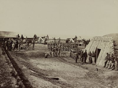
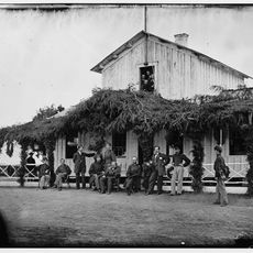
Fort Totten is a Civil War earthwork fortification in Northeast Washington situated on elevated ground about 3 miles north of the Capitol. The site preserves earth mounds, defensive ditches, and two powder magazines that demonstrate the original construction of the installation.

Construction of the fort began in August 1861 and was completed by 1863, equipped with approximately 20 cannons including a powerful Parrott rifle. The installation saw action during the Confederate attack in 1864 and served as a critical defensive position for the capital.

The fort was part of a network of defenses that protected the city during the Civil War and remains a symbol of the capital's wartime security measures. Visitors can see how this installation connected with other fortifications to create a protective ring around Washington.

The site is accessible via Fort Totten Metro Station, which connects to three transit lines and provides direct access to the park grounds. Walking trails and interpretive signs throughout the property help visitors understand the layout and purpose of the fortification.

The fort guarded President Lincoln's summer retreat at the Soldiers' Home while also serving as a strategic outpost positioned between two neighboring fortifications. This dual role as both a presidential security measure and a defensive anchor made it particularly important during the conflict.

The community of curious travelers

AroundUs brings together thousands of curated places, local tips, and hidden gems, enriched daily by 60,000 contributors worldwide.

Start exploring
Location
Inception
August 1861
Part of
Civil War defenses of Washington, D.C., Fort Circle Parks
GPS coordinates
38.94861,-77.00472
Latest update
December 10, 2025 20:00
Around this place
Basilica of the National Shrine of the Immaculate Conception
United States of America

Basilica of the National Shrine of the Immaculate Conception

1.7 km
Rock Creek Cemetery
United States of America

Rock Creek Cemetery

727 m
Adams Memorial
United States of America

Adams Memorial

503 m
Soldiers' and Airmen's Home National Cemetery
United States of America

Soldiers' and Airmen's Home National Cemetery

593 m
Brightwood Park
United States of America

Brightwood Park

1.6 km
Newton Theater
United States of America

Newton Theater

1.9 km
Ukrainian Catholic National Shrine of the Holy Family
United States of America

Ukrainian Catholic National Shrine of the Holy Family

1 km
Saint Anselm's Abbey
United States of America

Saint Anselm's Abbey

1.8 km
Rabboni
United States of America

Rabboni

560 m
Hubbard Bell Grossman Pillot Memorial
United States of America

Hubbard Bell Grossman Pillot Memorial

568 m
St. Paul's Episcopal Church
United States of America

St. Paul's Episcopal Church

744 m
Fort Slocum
United States of America

Fort Slocum

1.5 km
Armed Forces Retirement Home-Washington
United States of America

Armed Forces Retirement Home-Washington

1.4 km
Frederick Keep Monument
United States of America

Frederick Keep Monument

640 m
Maloney Hall
United States of America

Maloney Hall

1.8 km
Heurich Mausoleum
United States of America

Heurich Mausoleum

622 m
Caldwell Hall
United States of America

Caldwell Hall

1.5 km
Lamond-Riggs Neighborhood Library
United States of America

Lamond-Riggs Neighborhood Library

825 m
Petworth Gardens
United States of America

Petworth Gardens

884 m
Edwin B. Hay
United States of America

Edwin B. Hay

395 m
Charles Richard Drew Memorial Bridge
United States of America

Charles Richard Drew Memorial Bridge

1.9 km
Goff Memorial
United States of America

Goff Memorial

414 m
Houser Memorial
United States of America

Houser Memorial

401 m
Thompson-Harding Monument
United States of America

Thompson-Harding Monument

565 m
Kauffmann Memorial
United States of America

Kauffmann Memorial

673 m
Fort Totten Park
United States of America

Fort Totten Park

62 m
U.S. Soldiers' and Airmen's Home
United States of America

U.S. Soldiers' and Airmen's Home

979 m
The Hampshire
United States of America

The Hampshire

792 m
Show the full map
« Fort Totten - Civil War earthwork fort in Northeast Washington, United States » is provided by Around Us (aroundus.com). Images and texts are derived from Wikimedia project under a Creative Commons license. You are allowed to copy, distribute, and modify copies of this page, under the conditions set by the license, as long as this note is clearly visible.

Discover hidden gems everywhere you go!

From secret cafés to breathtaking viewpoints, skip the crowded tourist spots and find places that match your style. Our app makes it easy with voice search, smart filtering, route optimization, and insider tips from travelers worldwide. Download now for the complete mobile experience.

Around Us App Screenshot

A unique approach to discovering new places

Le Figaro

All the places worth exploring

France Info

A tailor-made excursion in just a few clicks

20 Minutes

Around Us
Travel Guide & Maps
Download

Send to your phone

QR Code
1

Open the camera app on your mobile.

2

Point at the QR code with your camera. A notification will appear.

3

Tap the notification to open the link.