Enable Location

We need your location to show you interesting places around you

Discover nearby places

Find interesting locations and hidden gems around you

Precise directions

Get accurate directions and distances to places

Your location is never shared with other users. It's only used when you tap the location button.

Lafayette County Training School

Log in to your account

Start exploring — it's free

Trusted by 62,063 travelers worldwide

Continue with Google
Continue with Apple
or

We will send you a code to connect

By continuing, you accept our Terms and Conditions and our Privacy Policy

Check your inbox

We've sent a pincode in your inbox. Please enter the code below.

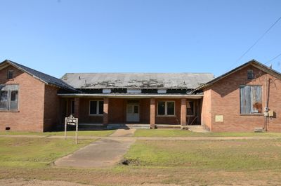
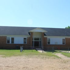
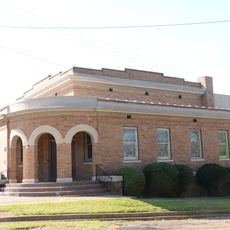
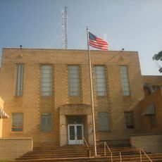
Lafayette County Training School, Historic school building in Stamps, Arkansas

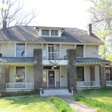
This school is a brick structure in Stamps, Arkansas, designed in an H-shaped layout with classrooms positioned along the side wings. The central section contains administrative and gathering spaces including an office, library, and auditorium.

The building was constructed in 1929 with support from the Rosenwald Fund and initially served African-American students. It remained the county's only preserved school of this type after integration took place in 1969.

The building reflects architectural styles common in early 20th-century American education, with design choices that shaped how schools looked and functioned during that era. The structure shows how educational spaces were planned and built for community use.

The building is located on Berry Street in Stamps and remains at its original site. Its position within the town makes it readily accessible to those exploring local history.

The school served as a formative educational experience for its early students during a transformative period in American education and civil rights. Its role extended beyond classroom instruction to reflect broader community values and aspirations.

The community of curious travelers

AroundUs brings together thousands of curated places, local tips, and hidden gems, enriched daily by 60,000 contributors worldwide.

Start exploring
Location
Address
1046 Berry Street
GPS coordinates
33.35310,-93.48810
Latest update
December 14, 2025 09:45
Around this place
Battle Mound Site
United States of America

Battle Mound Site

18.3 km
Conway Cemetery State Park
United States of America

Conway Cemetery State Park

33.3 km
Frog Level
United States of America

Frog Level

15.3 km
Logoly State Park
United States of America

Logoly State Park

28 km
Greek Amphitheatre
United States of America

Greek Amphitheatre

24.6 km
Kate Turner House
United States of America

Kate Turner House

24.3 km
Red River Bridge
United States of America

Red River Bridge

20.2 km
Columbia County Courthouse
United States of America

Columbia County Courthouse

24.9 km
Magnolia Colored School Historic District
United States of America

Magnolia Colored School Historic District

24.9 km
Dolph Camp, Bussey and Peace Halls Historic District
United States of America

Dolph Camp, Bussey and Peace Halls Historic District

24.6 km
Magnolia Commercial Historic District
United States of America

Magnolia Commercial Historic District

24.9 km
First Methodist Church
United States of America

First Methodist Church

8.5 km
Dr. H.A. Longino House
United States of America

Dr. H.A. Longino House

24.7 km
Peoples Bank and Loan Building
United States of America

Peoples Bank and Loan Building

8.3 km
Wynn-Price House
United States of America

Wynn-Price House

21.9 km
Lafayette County Courthouse
United States of America

Lafayette County Courthouse

8.3 km
Old Alexander House
United States of America

Old Alexander House

32.5 km
President's House
United States of America

President's House

24.6 km
Cross and Nelson Hall Historic District
United States of America

Cross and Nelson Hall Historic District

24.4 km
First Presbyterian Church
United States of America

First Presbyterian Church

1.1 km
Ozmer House
United States of America

Ozmer House

25.3 km
Couch-Marshall House
United States of America

Couch-Marshall House

24.7 km
Overstreet Hall
United States of America

Overstreet Hall

24.5 km
Nesburt T. Ruggles House
United States of America

Nesburt T. Ruggles House

29.5 km
Waldo Water Tower
United States of America

Waldo Water Tower

18.1 km
P.D. Burton House
United States of America

P.D. Burton House

8.5 km
King-Whatley Building
United States of America

King-Whatley Building

8.3 km
Cameo Theatre
United States of America

Cameo Theatre

25 km
Show the full map
« Lafayette County Training School - Historic school building in Stamps, Arkansas » is provided by Around Us (aroundus.com). Images and texts are derived from Wikimedia project under a Creative Commons license. You are allowed to copy, distribute, and modify copies of this page, under the conditions set by the license, as long as this note is clearly visible.

Discover hidden gems everywhere you go!

From secret cafés to breathtaking viewpoints, skip the crowded tourist spots and find places that match your style. Our app makes it easy with voice search, smart filtering, route optimization, and insider tips from travelers worldwide. Download now for the complete mobile experience.

Around Us App Screenshot

A unique approach to discovering new places

Le Figaro

All the places worth exploring

France Info

A tailor-made excursion in just a few clicks

20 Minutes

Around Us
Travel Guide & Maps
Download

Send to your phone

QR Code
1

Open the camera app on your mobile.

2

Point at the QR code with your camera. A notification will appear.

3

Tap the notification to open the link.