Enable Location

We need your location to show you interesting places around you

Discover nearby places

Find interesting locations and hidden gems around you

Precise directions

Get accurate directions and distances to places

Your location is never shared with other users. It's only used when you tap the location button.

Conway Cemetery State Park

Log in to your account

Start exploring — it's free

Trusted by 62,061 travelers worldwide

Continue with Google
Continue with Apple
or

We will send you a code to connect

By continuing, you accept our Terms and Conditions and our Privacy Policy

Check your inbox

We've sent a pincode in your inbox. Please enter the code below.

Conway Cemetery State Park

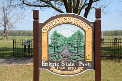
Conway Cemetery State Park, Historical cemetery in Lafayette County, Arkansas.

Conway Cemetery State Park is a state park in Lafayette County containing burial grounds of the Conway and Bradley families. The grounds span about 11.5 acres, with a small cemetery situated within the larger parkland.

The park preserves graves of the Conway family, whose member James Sevier Conway served as Arkansas's first governor from 1836 to 1840. The family held significant influence during the state's territorial period and into the Civil War era.

The cemetery reflects the influence of the Conway-Johnson family dynasty in Arkansas politics from territorial days through the American Civil War period.

The park welcomes visitors throughout the day and offers parking spaces and picnic facilities on the grounds. Basic amenities are available, so it is helpful to check current hours before planning a visit.

Local residents began preservation efforts in 1975, leading to the site's listing on the National Register of Historic Places in 1977. This grassroots initiative saved the location from being forgotten and turned it into a formally protected historical site.

The community of curious travelers

AroundUs brings together thousands of curated places, local tips, and hidden gems, enriched daily by 60,000 contributors worldwide.

Start exploring
Location
Inception
March 29, 1986
Elevation above the sea
79 m
GPS coordinates
33.10189,-93.68306
Latest update
December 13, 2025 12:40
Around this place
Battle Mound Site
United States of America

Battle Mound Site

21.9 km
Lafayette County Training School
United States of America

Lafayette County Training School

33.3 km
Frog Level
United States of America

Frog Level

36.7 km
Greek Amphitheatre
United States of America

Greek Amphitheatre

46.8 km
Kate Turner House
United States of America

Kate Turner House

44.5 km
Red River Bridge
United States of America

Red River Bridge

28.4 km
Kiblah School
United States of America

Kiblah School

18 km
Columbia County Courthouse
United States of America

Columbia County Courthouse

45.1 km
Hughes House
United States of America

Hughes House

45.7 km
Magnolia Colored School Historic District
United States of America

Magnolia Colored School Historic District

44.7 km
Magnolia Commercial Historic District
United States of America

Magnolia Commercial Historic District

45.1 km
First Methodist Church
United States of America

First Methodist Church

30.2 km
Dr. H.A. Longino House
United States of America

Dr. H.A. Longino House

44.9 km
Peoples Bank and Loan Building
United States of America

Peoples Bank and Loan Building

30 km
Wynn-Price House
United States of America

Wynn-Price House

29.3 km
Lafayette County Courthouse
United States of America

Lafayette County Courthouse

30.1 km
Cross and Nelson Hall Historic District
United States of America

Cross and Nelson Hall Historic District

46.7 km
First Presbyterian Church
United States of America

First Presbyterian Church

33.8 km
Averitt House
United States of America

Averitt House

37.8 km
Couch-Marshall House
United States of America

Couch-Marshall House

44.7 km
Mathews-Powell House
United States of America

Mathews-Powell House

43.6 km
Overstreet Hall
United States of America

Overstreet Hall

46.6 km
Waldo Water Tower
United States of America

Waldo Water Tower

45.8 km
P.D. Burton House
United States of America

P.D. Burton House

30.1 km
King-Whatley Building
United States of America

King-Whatley Building

30 km
Cameo Theatre
United States of America

Cameo Theatre

45.3 km
Spring Theatre
United States of America

Spring Theatre

23.4 km
Red River LA 2 Bridge
United States of America

Red River LA 2 Bridge

26.6 km
Show the full map
« Conway Cemetery State Park - Historical cemetery in Lafayette County, Arkansas » is provided by Around Us (aroundus.com). Images and texts are derived from Wikimedia project under a Creative Commons license. You are allowed to copy, distribute, and modify copies of this page, under the conditions set by the license, as long as this note is clearly visible.

Discover hidden gems everywhere you go!

From secret cafés to breathtaking viewpoints, skip the crowded tourist spots and find places that match your style. Our app makes it easy with voice search, smart filtering, route optimization, and insider tips from travelers worldwide. Download now for the complete mobile experience.

Around Us App Screenshot

A unique approach to discovering new places

Le Figaro

All the places worth exploring

France Info

A tailor-made excursion in just a few clicks

20 Minutes

Around Us
Travel Guide & Maps
Download

Send to your phone

QR Code
1

Open the camera app on your mobile.

2

Point at the QR code with your camera. A notification will appear.

3

Tap the notification to open the link.