Enable Location

We need your location to show you interesting places around you

Discover nearby places

Find interesting locations and hidden gems around you

Precise directions

Get accurate directions and distances to places

Your location is never shared with other users. It's only used when you tap the location button.

Battle Mound Site

Log in to your account

Start exploring — it's free

Trusted by 62,806 travelers worldwide

Continue with Google
Continue with Apple
or

We will send you a code to connect

By continuing, you accept our Terms and Conditions and our Privacy Policy

Check your inbox

We've sent a pincode in your inbox. Please enter the code below.

Battle Mound Site

Battle Mound Site, Archaeological site in Magnolia, United States.

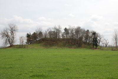
Battle Mound Site is an earthwork along the Red River in Louisiana, featuring a large central mound with several smaller ones scattered around it. The main structure rises significantly above the surrounding landscape and shows how the site was constructed over time.

The mounds were built between 1200 and 1400 when Caddoan Mississippian societies thrived in this region. This period saw the development of organized settlements with distinct social divisions in the southeastern area.

The site contains multiple burial grounds and occupation areas that provide evidence of native settlements and their social structures in the southeastern United States.

The site is open and easy to explore with natural trails around the mounds requiring no special equipment. Visitors should wear sturdy shoes and dress for the weather, as the riverside location can be muddy or wet depending on the season.

The site takes its name from James J. Battle, a settler from North Carolina who purchased the land in 1844 and gave it his family name. Though the mounds predate him by four centuries, the connection between the early settler and this ancient place creates an interesting local history.

The community of curious travelers

AroundUs brings together thousands of curated places, local tips, and hidden gems, enriched daily by 60,000 contributors worldwide.

Start exploring
Location
GPS coordinates
33.29889,-93.67333
Latest update
December 12, 2025 07:58
Around this place
Conway Cemetery State Park
United States of America

Conway Cemetery State Park

21.9 km
Lafayette County Training School
United States of America

Lafayette County Training School

18.3 km
Frog Level
United States of America

Frog Level

30.1 km
Four States Auto Museum
United States of America

Four States Auto Museum

36.7 km
Red River Bridge
United States of America

Red River Bridge

7 km
Buhrman-Pharr Hardware Company Historic District
United States of America

Buhrman-Pharr Hardware Company Historic District

36.7 km
East Broad Street Historic District
United States of America

East Broad Street Historic District

37 km
Miller County Courthouse
United States of America

Miller County Courthouse

35.8 km
Kiblah School
United States of America

Kiblah School

32.8 km
Bottoms House
United States of America

Bottoms House

36.6 km
Claude Foulke House
United States of America

Claude Foulke House

36.6 km
J.K. Wadley House
United States of America

J.K. Wadley House

36.8 km
Cotton Belt Railroad Office Building
United States of America

Cotton Belt Railroad Office Building

36.8 km
Augustus M. Garrison House
United States of America

Augustus M. Garrison House

36.7 km
Wallace Adams Service Station
United States of America

Wallace Adams Service Station

36.8 km
First Methodist Church
United States of America

First Methodist Church

11 km
Patrick J. Ahern House
United States of America

Patrick J. Ahern House

36.9 km
Peoples Bank and Loan Building
United States of America

Peoples Bank and Loan Building

11 km
Wynn-Price House
United States of America

Wynn-Price House

8.5 km
Lafayette County Courthouse
United States of America

Lafayette County Courthouse

11.1 km
Ritchie Grocery Building
United States of America

Ritchie Grocery Building

36.8 km
First Presbyterian Church
United States of America

First Presbyterian Church

18 km
Kittrell House
United States of America

Kittrell House

36.9 km
Swift Building
United States of America

Swift Building

36.8 km
Averitt House
United States of America

Averitt House

27.6 km
Waldo Water Tower
United States of America

Waldo Water Tower

35.9 km
P.D. Burton House
United States of America

P.D. Burton House

11 km
King-Whatley Building
United States of America

King-Whatley Building

11 km
Show the full map
« Battle Mound Site - Archaeological site in Magnolia, United States » is provided by Around Us (aroundus.com). Images and texts are derived from Wikimedia project under a Creative Commons license. You are allowed to copy, distribute, and modify copies of this page, under the conditions set by the license, as long as this note is clearly visible.

Discover hidden gems everywhere you go!

From secret cafés to breathtaking viewpoints, skip the crowded tourist spots and find places that match your style. Our app makes it easy with voice search, smart filtering, route optimization, and insider tips from travelers worldwide. Download now for the complete mobile experience.

Around Us App Screenshot

A unique approach to discovering new places

Le Figaro

All the places worth exploring

France Info

A tailor-made excursion in just a few clicks

20 Minutes

Around Us
Travel Guide & Maps
Download

Send to your phone

QR Code
1

Open the camera app on your mobile.

2

Point at the QR code with your camera. A notification will appear.

3

Tap the notification to open the link.