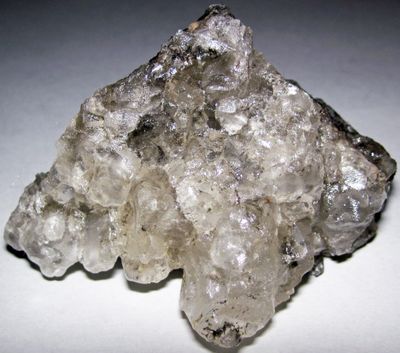
Wellington Formation, Geological formation in Kansas, United States.
The Wellington Formation is a geological layering in Kansas composed of sedimentary rocks including shale, sandstone, and limestone arranged in distinct strata. These layers were created during the Permian period and remain visible today in mining areas and excavation sites.
This layering developed during the Late Permian period when marine sediments accumulated in an ancient sea that once covered this region. The rocks visible today record a vanished ocean environment from that distant geological time.
This formation holds significance for scientists who study ancient marine life, with fossils revealing information about creatures and environments that existed millions of years ago.
You can view the formation in quarries and mining areas, particularly throughout central Kansas where the layers are most accessible. Wear appropriate footwear and follow safety guidelines when visiting active mining sites.
Fossils of Meganeuropsis permianum have been found within these layers, representing one of the largest flying insects ever to exist in Earth's history. This giant insect reveals how different life forms were during that ancient marine period.
Location: Kansas
GPS coordinates: 38.60000,-97.20000
Latest update: December 14, 2025 12:21
Dwight D. Eisenhower Presidential Library, Museum and Boyhood Home
34.8 km
Eisenhower Home
34.8 km
Lebold Mansion
35.2 km
Alexanderwohl Mennonite Church
39.4 km
Atchison, Topeka and Santa Fe Railway 3415
35 km
Abilene and Smoky Valley Railroad
34.6 km
Marion Reservoir
27.6 km
Whiteford Archeological Site
40.9 km
Swedish Pavilion
41.4 km
Lander Park Carousel
34.7 km
Farmers State Bank
41.5 km
St. John's Episcopal Church
35.7 km
Canton Township Carnegie Library
30.8 km
Trinity Evangelical Lutheran Church
35.4 km
Smoky Valley Roller Mill
41.4 km
Berquist & Nelson Drugstore Building
41.5 km
Rosberg-Holmgren-Clareen Block
41.5 km
Dickinson County Courthouse
35.2 km
Versteeg-Swisher House
34.6 km
Marion County Courthouse
32.3 km
Abilene Downtown Historic District
35.3 km
Six Mile Creek Stage Station Historic District
30.1 km
Teichgraeber–Runbeck House
41.5 km
Staatz House
37.6 km
John W. Birchmore House
36.5 km
Eliason Barn
16.9 km
Heritage Center
34.7 km
Hobbs Creek Bridge
16.5 kmVisited this place? Tap the stars to rate it and share your experience / photos with the community! Try now! You can cancel it anytime.
Discover hidden gems everywhere you go!
From secret cafés to breathtaking viewpoints, skip the crowded tourist spots and find places that match your style. Our app makes it easy with voice search, smart filtering, route optimization, and insider tips from travelers worldwide. Download now for the complete mobile experience.
A unique approach to discovering new places❞
— Le Figaro
All the places worth exploring❞
— France Info
A tailor-made excursion in just a few clicks❞
— 20 Minutes