Enable Location

We need your location to show you interesting places around you

Discover nearby places

Find interesting locations and hidden gems around you

Precise directions

Get accurate directions and distances to places

Your location is never shared with other users. It's only used when you tap the location button.

Log in to your account

Start exploring — it's free

Trusted by 63,414 travelers worldwide

Continue with Google
Continue with Apple
or

We will send you a code to connect

By continuing, you accept our Terms and Conditions and our Privacy Policy

Check your inbox

We've sent a pincode in your inbox. Please enter the code below.

Marion Reservoir
Discussion Reviews Photo
3.2k Popularity

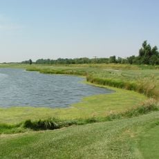
Marion Reservoir, reservoir in Marion County, Kansas

Marion Reservoir is a large lake in south-central Kansas covering around 6,000 acres of water and land. The lake has several campgrounds along its shores, calm waters suitable for boating, and good fishing for catfish, crappie, and walleye.

The lake was created by building a dam on a nearby river to control flooding and supply water to local farms. Over time the structure has been improved to keep the area safe and operational for both water management and recreation.

The reservoir serves as a gathering place where locals escape to spend time outdoors with family and friends. The water draws people for fishing, boating, and camping as regular parts of life in this region.

The reservoir is easily accessible by car with signs leading to the dam and fishing areas, though it is wise to reserve a spot in advance especially on weekends. Visitors should drain all water from equipment like buckets and livewells to prevent spreading invasive zebra mussels to other waters.

Artificial structures like habitat cubes and brushpiles have been placed strategically throughout the lake to give fish hiding and breeding spaces and make fishing more predictable. These underwater features are located at known spots, helping experienced anglers target specific areas where fish gather.

The community of curious travelers

AroundUs brings together thousands of curated places, local tips, and hidden gems, enriched daily by 60,000 contributors worldwide.

Start exploring
Location
GPS coordinates
38.36890,-97.08500
Latest update
February 9, 2026 08:23
Around this place
Alexanderwohl Mennonite Church
United States of America

Alexanderwohl Mennonite Church

24.8 km
Warkentin House
United States of America

Warkentin House

42.5 km
Sand Creek Station Golf Course
United States of America

Sand Creek Station Golf Course

45.9 km
Harvey House
United States of America

Harvey House

19.8 km
Fischer Field Stadium
United States of America

Fischer Field Stadium

43.2 km
Wellington Formation
United States of America

Wellington Formation

27.6 km
Peabody Historical Library Museum
United States of America

Peabody Historical Library Museum

22.5 km
Lower Fox Creek School
United States of America

Lower Fox Creek School

46.7 km
Clements Stone Arch Bridge
United States of America

Clements Stone Arch Bridge

31.7 km
Carnegie Library
United States of America

Carnegie Library

42.7 km
Peabody Downtown Historic District
United States of America

Peabody Downtown Historic District

22.7 km
Peabody City Park
United States of America

Peabody City Park

22.7 km
W.H. Morgan House
United States of America

W.H. Morgan House

22.6 km
Cottonwood River Pratt Truss Bridge
United States of America

Cottonwood River Pratt Truss Bridge

25.1 km
Whitney Ranch
United States of America

Whitney Ranch

37.5 km
Canton Township Carnegie Library
United States of America

Canton Township Carnegie Library

29.9 km
Peabody Township Library
United States of America

Peabody Township Library

22.5 km
Burns Union School
United States of America

Burns Union School

35.6 km
Clover Cliff Ranch House
United States of America

Clover Cliff Ranch House

34.2 km
Marion County Courthouse
United States of America

Marion County Courthouse

6.2 km
Six Mile Creek Stage Station Historic District
United States of America

Six Mile Creek Stage Station Historic District

33.1 km
William C. & Jane Shaft House
United States of America

William C. & Jane Shaft House

31.3 km
Eliason Barn
United States of America

Eliason Barn

42.6 km
Mennonite Settler statue
United States of America

Mennonite Settler statue

43.1 km
Spring Hill Farm and Stock Ranch House
United States of America

Spring Hill Farm and Stock Ranch House

46.6 km
Whitney Ranch - House
United States of America

Whitney Ranch - House

37.5 km
Hobbs Creek Bridge
United States of America

Hobbs Creek Bridge

39.7 km
Newton Main Street Historic District II
United States of America

Newton Main Street Historic District II

42.3 km
Show the full map
Reviews
Share your experience

No review yet

Discussions
Start a discussion...

No discussion yet

« Marion Reservoir - reservoir in Marion County, Kansas » is provided by Around Us (aroundus.com). Images and texts are derived from Wikimedia project under a Creative Commons license. You are allowed to copy, distribute, and modify copies of this page, under the conditions set by the license, as long as this note is clearly visible.

Discover hidden gems everywhere you go!

From secret cafés to breathtaking viewpoints, skip the crowded tourist spots and find places that match your style. Our app makes it easy with voice search, smart filtering, route optimization, and insider tips from travelers worldwide. Download now for the complete mobile experience.

Around Us App Screenshot

A unique approach to discovering new places

Le Figaro

All the places worth exploring

France Info

A tailor-made excursion in just a few clicks

20 Minutes

Around Us
Travel Guide & Maps
Download

Send to your phone

QR Code
1

Open the camera app on your mobile.

2

Point at the QR code with your camera. A notification will appear.

3

Tap the notification to open the link.