Enable Location

We need your location to show you interesting places around you

Discover nearby places

Find interesting locations and hidden gems around you

Precise directions

Get accurate directions and distances to places

Your location is never shared with other users. It's only used when you tap the location button.

Magruder Plots

Log in to your account

Start exploring — it's free

Trusted by 62,561 travelers worldwide

Continue with Google
Continue with Apple
or

We will send you a code to connect

By continuing, you accept our Terms and Conditions and our Privacy Policy

Check your inbox

We've sent a pincode in your inbox. Please enter the code below.

Magruder Plots, human settlement in United States of America

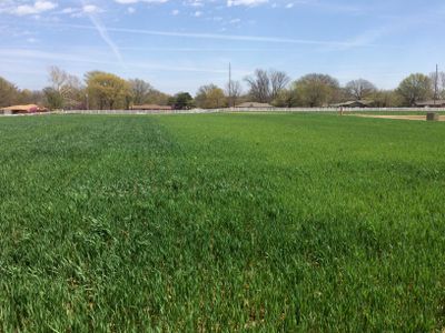
The Magruder Plots are an experimental field area in Stillwater, Oklahoma, used for wheat research since the late 1800s. The land is divided into smaller parcels with different soil treatments and fertilizer applications studied systematically to understand their effects on crop yield and soil health.

The first Magruder Plots were established in 1892 by A.C. Magruder, the first agricultural professor at Oklahoma A&M College, making them one of the oldest field trial sites in the United States. In the 1930s, the experimental area was expanded and restructured to compare different fertilizer and soil treatment options.

The Magruder Plots are named after A.C. Magruder, the first agricultural researcher at the station who encouraged local farmers to visit and learn from his experiments. This connection between scientific research and practical farming has shaped how the community views innovation and tradition in agriculture to this day.

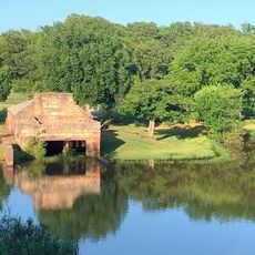
The site is located west of the Stillwater campus along Highway 51 and is easy to locate, but access is limited because ongoing research restricts public visits. During annual field days in May, interested visitors can observe the work and learn about current findings from researchers on site.

The original soil from some experimental parcels was relocated to a nearby site in the 1940s and replanted to preserve the long-term research continuity when the old area was needed for new buildings. This remarkable relocation shows researchers' commitment to maintaining consistent data collection across more than a century.

The community of curious travelers

AroundUs brings together thousands of curated places, local tips, and hidden gems, enriched daily by 60,000 contributors worldwide.

Start exploring
Location
Part of
Oklahoma State University–Stillwater
GPS coordinates
36.11690,-97.08750
Latest update
February 9, 2026 07:42
Around this place
Boone Pickens Stadium
United States of America

Boone Pickens Stadium

2.1 km
National Wrestling Hall of Fame and Museum
United States of America

National Wrestling Hall of Fame and Museum

2.4 km
United States of America

Colvin Center

1.4 km
Jim Thorpe House
United States of America

Jim Thorpe House

24.9 km
Old Central
United States of America

Old Central

1.9 km
Student Union
United States of America

Student Union

1.8 km
Stillwater Santa Fe Depot
United States of America

Stillwater Santa Fe Depot

3 km
Oklahoma Botanical Garden and Arboretum
United States of America

Oklahoma Botanical Garden and Arboretum

1.4 km
Morrill Hall
United States of America

Morrill Hall

2 km
Josephine Reifsnyder Lustron House
United States of America

Josephine Reifsnyder Lustron House

622 m
Whitehurst Hall
United States of America

Whitehurst Hall

1.6 km
Cottonwood Community Center
United States of America

Cottonwood Community Center

3.3 km
Noble County Courthouse
United States of America

Noble County Courthouse

26 km
James E. Berry House
United States of America

James E. Berry House

2.3 km
Payne County Courthouse
United States of America

Payne County Courthouse

2.5 km
William Frick House
United States of America

William Frick House

2.3 km
Citizens Bank Building
United States of America

Citizens Bank Building

2.7 km
Hoke Building
United States of America

Hoke Building

2.5 km
First National Bank and Trust Company Building
United States of America

First National Bank and Trust Company Building

25.9 km
Perry Courthouse Square Historic District
United States of America

Perry Courthouse Square Historic District

26.1 km
Walker Building
United States of America

Walker Building

2.6 km
Selph Building
United States of America

Selph Building

2.5 km
Oklahoma A & M College Agronomy Barn and Seed House
United States of America

Oklahoma A & M College Agronomy Barn and Seed House

550 m
Morrison Baptist Church
United States of America

Morrison Baptist Church

21.5 km
Wrestling Hall of Fame
United States of America

Wrestling Hall of Fame

2.4 km
OSU Museum of Art
United States of America

OSU Museum of Art

2.5 km
Perry Lake Park Boathouse
United States of America

Perry Lake Park Boathouse

23.6 km
Perry Lake
United States of America

Perry Lake

23.8 km
Show the full map
« Magruder Plots - human settlement in United States of America » is provided by Around Us (aroundus.com). Images and texts are derived from Wikimedia project under a Creative Commons license. You are allowed to copy, distribute, and modify copies of this page, under the conditions set by the license, as long as this note is clearly visible.

Discover hidden gems everywhere you go!

From secret cafés to breathtaking viewpoints, skip the crowded tourist spots and find places that match your style. Our app makes it easy with voice search, smart filtering, route optimization, and insider tips from travelers worldwide. Download now for the complete mobile experience.

Around Us App Screenshot

A unique approach to discovering new places

Le Figaro

All the places worth exploring

France Info

A tailor-made excursion in just a few clicks

20 Minutes

Around Us
Travel Guide & Maps
Download

Send to your phone

QR Code
1

Open the camera app on your mobile.

2

Point at the QR code with your camera. A notification will appear.

3

Tap the notification to open the link.