James B. Garrison Bridge

Log in to your account

AroundUs is a community-driven map of interesting places, built by curious explorers like you. It grows with every review, story, and photo you share.
Connect to save your favorite spots, contribute locations, and create personalized routes.
Continue with Google
Continue with Apple
Continue with X
Continue with Facebook
Continue with email
By continuing, you accept our Terms and Conditions and our Privacy Policy
Create an account

James B. Garrison Bridge

Add to collection
Map
Suggest a change
Share

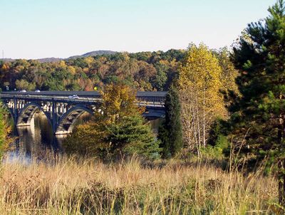
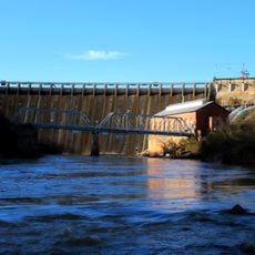
James B. Garrison Bridge, Concrete arch bridge in Stanly County, North Carolina

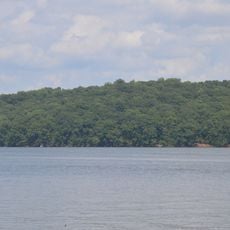
James B. Garrison Bridge is a reinforced concrete arch bridge spanning across Lake Tillery to connect Stanly and Montgomery Counties. The structure carries traffic on NC 24/27/73 with its series of arches supporting vehicles between the eastern and western shorelines.

The bridge opened in 1927 to replace the earlier Swift Island Ferry Bridge, which was submerged when Lake Tillery was created by Carolina Power and Light. This construction marked an important shift from ferry transportation to a permanent road connection across the water.

Named after North Carolina State Senator James B. Garrison in 1979, the structure represents the engineering capabilities of early 20th century American infrastructure.

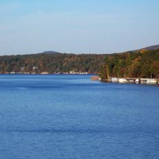
The bridge is open daily for vehicle traffic and provides an important crossing point for those traveling between the two counties. You can drive across or stop at nearby viewing areas to take in views of the lake and surrounding landscape.

The original Swift Island Bridge required unconventional demolition methods involving multiple attempts with artillery and aerial attacks before explosives finally brought it down. This dramatic removal process reflects the challenges of infrastructure transition during a major landscape transformation.

Location: North Carolina

Official opening: 1927

GPS coordinates: 35.30830,-80.07950

Latest update: December 14, 2025 13:08

Photos
Around this place
Lake Tillery
United States of America

Lake Tillery

11.4 km
Badin Lake
United States of America

Badin Lake

12.5 km
Town Creek Indian Mound
United States of America

Town Creek Indian Mound

19.5 km
Pisgah Covered Bridge
United States of America

Pisgah Covered Bridge

31 km
Tuckertown Reservoir
United States of America

Tuckertown Reservoir

23.1 km
United States of America

Birkhead Mountains Wilderness

35.8 km
Hardaway Site
United States of America

Hardaway Site

11.8 km
United States of America

Pee Dee National Wildlife Refuge

25.2 km
Narrows Dam and Power Plant Complex
United States of America

Narrows Dam and Power Plant Complex

12.3 km
Downtown Albemarle Historic District
United States of America

Downtown Albemarle Historic District

11.8 km
Five Points Historic District
United States of America

Five Points Historic District

11.5 km
Isaiah Wilson Snugs House
United States of America

Isaiah Wilson Snugs House

11.6 km
Montgomery County Courthouse
United States of America

Montgomery County Courthouse

17.8 km
Mount Pleasant Collegiate Institute Historic District
United States of America

Mount Pleasant Collegiate Institute Historic District

34.1 km
Thomas Marcellus Denning House
United States of America

Thomas Marcellus Denning House

12 km
Mount Pleasant Historic District
United States of America

Mount Pleasant Historic District

33.9 km
Pee Dee Avenue Historic District
United States of America

Pee Dee Avenue Historic District

11 km
Randle House
United States of America

Randle House

5.6 km
First Congregational Church
United States of America

First Congregational Church

33.2 km
Mount Ebal Methodist Protestant Church
United States of America

Mount Ebal Methodist Protestant Church

35.4 km
Liberty Hill School
United States of America

Liberty Hill School

27.1 km
Albemarle Opera House
United States of America

Albemarle Opera House

11.8 km
United States Post Office
United States of America

United States Post Office

36.9 km
Mount Gilead Downtown Historic District
United States of America

Mount Gilead Downtown Historic District

12.6 km
Second Street Historic District
United States of America

Second Street Historic District

11.8 km
Town Creek Indian Mound State Historic Site
United States of America

Town Creek Indian Mound State Historic Site

19.5 km
Morrow Mountain State Park
United States of America

Morrow Mountain State Park

9.5 km
Pfeiffer Junior College Historic District
United States of America

Pfeiffer Junior College Historic District

27 km
Show the full map
Reviews

Visited this place? Tap the stars to rate it and share your experience / photos with the community! Try now! You can cancel it anytime.

« James B. Garrison Bridge - Concrete arch bridge in Stanly County, North Carolina » is provided by Around Us (aroundus.com). Images and texts are derived from Wikimedia project under a Creative Commons license. You are allowed to copy, distribute, and modify copies of this page, under the conditions set by the license, as long as this note is clearly visible.

Discover hidden gems everywhere you go!

From secret cafés to breathtaking viewpoints, skip the crowded tourist spots and find places that match your style. Our app makes it easy with voice search, smart filtering, route optimization, and insider tips from travelers worldwide. Download now for the complete mobile experience.

Around Us App Screenshot

A unique approach to discovering new places

Le Figaro

All the places worth exploring

France Info

A tailor-made excursion in just a few clicks

20 Minutes