Enable Location

We need your location to show you interesting places around you

Discover nearby places

Find interesting locations and hidden gems around you

Precise directions

Get accurate directions and distances to places

Your location is never shared with other users. It's only used when you tap the location button.

Narrows Dam and Power Plant Complex

Log in to your account

Start exploring — it's free

Trusted by 62,051 travelers worldwide

Continue with Google
Continue with Apple
or

We will send you a code to connect

By continuing, you accept our Terms and Conditions and our Privacy Policy

Check your inbox

We've sent a pincode in your inbox. Please enter the code below.

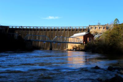
Narrows Dam and Power Plant Complex, Historic hydroelectric facility in Badin, United States.

The Narrows Dam and Power Plant Complex is a hydroelectric facility along the Yadkin River, composed of a concrete arch dam and power generation structures arranged across the site. The power plant building displays multiple bays with distinctive roofing features that reflect early 20th century industrial design.

Built in 1917 by Alcoa, the complex provided power to support industrial operations at the nearby Badin plant. Upon completion, it represented a significant engineering advancement in dam construction methods of its time.

The National Register of Historic Places recognized this industrial site on October 12, 1983 for its engineering achievements and economic contributions.

The site is spread across considerable ground, so allow time to see all parts thoroughly. Access may vary by area, so checking beforehand about which sections are open to visitors is a good idea.

Engineer James W. Rickey pioneered an innovative concrete arch design during construction that set a record for overflow dam height at completion. This technical solution demonstrated new possibilities for hydroelectric development.

The community of curious travelers

AroundUs brings together thousands of curated places, local tips, and hidden gems, enriched daily by 60,000 contributors worldwide.

Start exploring
Location
GPS coordinates
35.41860,-80.09250
Latest update
December 14, 2025 14:21
Around this place
High Rock Lake
United States of America

High Rock Lake

27.5 km
Lake Tillery
United States of America

Lake Tillery

23.7 km
Badin Lake
United States of America

Badin Lake

127 m
Town Creek Indian Mound
United States of America

Town Creek Indian Mound

30.1 km
Pisgah Covered Bridge
United States of America

Pisgah Covered Bridge

22.7 km
Tuckertown Reservoir
United States of America

Tuckertown Reservoir

12 km
United States of America

Birkhead Mountains Wilderness

25.7 km
Hardaway Site
United States of America

Hardaway Site

2.2 km
United States of America

North Carolina Aviation Museum

31.5 km
James B. Garrison Bridge
United States of America

James B. Garrison Bridge

12.3 km
Downtown Albemarle Historic District
United States of America

Downtown Albemarle Historic District

12.3 km
Five Points Historic District
United States of America

Five Points Historic District

12 km
Isaiah Wilson Snugs House
United States of America

Isaiah Wilson Snugs House

12.1 km
Montgomery County Courthouse
United States of America

Montgomery County Courthouse

19.3 km
Mount Pleasant Collegiate Institute Historic District
United States of America

Mount Pleasant Collegiate Institute Historic District

31.3 km
Thomas Marcellus Denning House
United States of America

Thomas Marcellus Denning House

11.8 km
Mount Pleasant Historic District
United States of America

Mount Pleasant Historic District

31.1 km
Randle House
United States of America

Randle House

17.4 km
Pee Dee Avenue Historic District
United States of America

Pee Dee Avenue Historic District

11.2 km
First Congregational Church
United States of America

First Congregational Church

30.5 km
Mount Ebal Methodist Protestant Church
United States of America

Mount Ebal Methodist Protestant Church

23.2 km
Albemarle Opera House
United States of America

Albemarle Opera House

12.3 km
Mount Gilead Downtown Historic District
United States of America

Mount Gilead Downtown Historic District

24.1 km
Second Street Historic District
United States of America

Second Street Historic District

12.1 km
Town Creek Indian Mound State Historic Site
United States of America

Town Creek Indian Mound State Historic Site

30.2 km
Morrow Mountain State Park
United States of America

Morrow Mountain State Park

2.9 km
North Carolina Pottery Center
United States of America

North Carolina Pottery Center

31.8 km
Pfeiffer Junior College Historic District
United States of America

Pfeiffer Junior College Historic District

18.9 km
Show the full map
« Narrows Dam and Power Plant Complex - Historic hydroelectric facility in Badin, United States » is provided by Around Us (aroundus.com). Images and texts are derived from Wikimedia project under a Creative Commons license. You are allowed to copy, distribute, and modify copies of this page, under the conditions set by the license, as long as this note is clearly visible.

Discover hidden gems everywhere you go!

From secret cafés to breathtaking viewpoints, skip the crowded tourist spots and find places that match your style. Our app makes it easy with voice search, smart filtering, route optimization, and insider tips from travelers worldwide. Download now for the complete mobile experience.

Around Us App Screenshot

A unique approach to discovering new places

Le Figaro

All the places worth exploring

France Info

A tailor-made excursion in just a few clicks

20 Minutes

Around Us
Travel Guide & Maps
Download

Send to your phone

QR Code
1

Open the camera app on your mobile.

2

Point at the QR code with your camera. A notification will appear.

3

Tap the notification to open the link.