Enable Location

We need your location to show you interesting places around you

Discover nearby places

Find interesting locations and hidden gems around you

Precise directions

Get accurate directions and distances to places

Your location is never shared with other users. It's only used when you tap the location button.

Log in to your account

Start exploring — it's free

Trusted by 63,735 travelers worldwide

Continue with Google
Continue with Apple
or

We will send you a code to connect

By continuing, you accept our Terms and Conditions and our Privacy Policy

Check your inbox

We've sent a pincode in your inbox. Please enter the code below.

Discussion Reviews Photo
1.2k Popularity

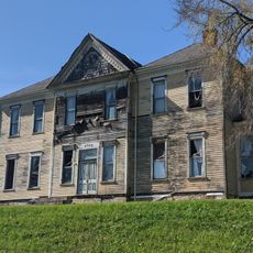
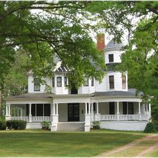
Dean Farm, farm near Louisburg, North Carolina, United States of America

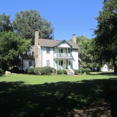
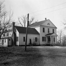
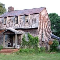
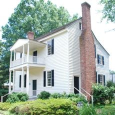
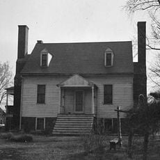
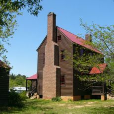
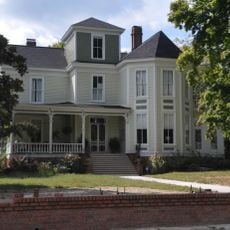
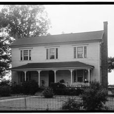
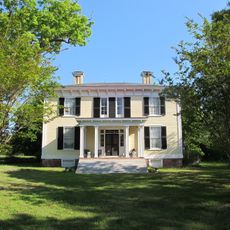
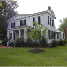
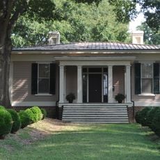
Dean Farm is a historic farm property in Franklin County, North Carolina, located about six miles east of Louisburg along Highway 56. The main house dates to around 1842 and features a two-story structure with three symmetrical sections on its front, combining Federal and Greek Revival architectural elements, while the grounds also contain a smokehouse, corn crib, equipment shed, and family cemetery.

Dean Farm was established around 1842 and reflects the building practices of rural farms during that era. The property was added to the National Register of Historic Places in 1975, recognizing its importance to Franklin County's history and the region's early agricultural heritage.

The name Dean Farm comes from the family who lived and worked this land for generations. Today, the farm shows how rural families organized their homes and outbuildings to handle daily tasks like food preservation and harvesting.

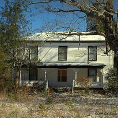
Dean Farm is located along North Carolina Highway 56 and is accessible when exploring the region. Visitors are advised to wear appropriate footwear, as the grounds consist of fields and older buildings that may have uneven surfaces.

The property contains a family cemetery, showing how the Dean family and their descendants remained connected to this land over many generations. The cemetery is a quiet, personal space that visitors often overlook, yet it offers important insight into the estate's long history.

The community of curious travelers

AroundUs brings together thousands of curated places, local tips, and hidden gems, enriched daily by 60,000 contributors worldwide.

Start exploring
Location
GPS coordinates
36.08920,-78.17940
Latest update
February 9, 2026 07:45
Around this place
Louisburg College
United States of America

Louisburg College

11 km
Medoc Mountain State Park
United States of America

Medoc Mountain State Park

32.9 km
Bennett Bunn Plantation
United States of America

Bennett Bunn Plantation

29.6 km
Triangle Metro Zoo
United States of America

Triangle Metro Zoo

30.2 km
Person Place
United States of America

Person Place

10.7 km
Rose Hill
United States of America

Rose Hill

17 km
Sterling Cotton Mill
United States of America

Sterling Cotton Mill

25 km
Shemuel Kearney House
United States of America

Shemuel Kearney House

27.2 km
Josiah Crudup House
United States of America

Josiah Crudup House

26.7 km
Wakelon School
United States of America

Wakelon School

31.5 km
Bissette-Cooley House
United States of America

Bissette-Cooley House

23.1 km
Fuller House
United States of America

Fuller House

10.9 km
Dr. Calvin Jones House
United States of America

Dr. Calvin Jones House

31.8 km
Green Hill House
United States of America

Green Hill House

11.4 km
Andrews-Moore House
United States of America

Andrews-Moore House

9.7 km
George and Neva Barbee House
United States of America

George and Neva Barbee House

32 km
Louisburg Historic District
United States of America

Louisburg Historic District

10.9 km
Dortch House
United States of America

Dortch House

30.1 km
Zollicoffer's Law Office
United States of America

Zollicoffer's Law Office

33.3 km
Dr. Samuel Perry House
United States of America

Dr. Samuel Perry House

12.3 km
Laurel Mill and Col. Jordan Jones House
United States of America

Laurel Mill and Col. Jordan Jones House

9.9 km
Nash County Courthouse
United States of America

Nash County Courthouse

22.8 km
Dr. J. H. Harris House
United States of America

Dr. J. H. Harris House

24.5 km
Mansfield Thornton House
United States of America

Mansfield Thornton House

33.2 km
Kenansville Historic District
United States of America

Kenansville Historic District

24.2 km
Williamson House
United States of America

Williamson House

10.6 km
Aldridge H. Vann House
United States of America

Aldridge H. Vann House

25 km
Franklin County Training School-Riverside Union School
United States of America

Franklin County Training School-Riverside Union School

11.5 km
Show the full map
Reviews
Share your experience

No review yet

Discussions
Start a discussion...

No discussion yet

« Dean Farm - farm near Louisburg, North Carolina, United States of America » is provided by Around Us (aroundus.com). Images and texts are derived from Wikimedia project under a Creative Commons license. You are allowed to copy, distribute, and modify copies of this page, under the conditions set by the license, as long as this note is clearly visible.

Discover hidden gems everywhere you go!

From secret cafés to breathtaking viewpoints, skip the crowded tourist spots and find places that match your style. Our app makes it easy with voice search, smart filtering, route optimization, and insider tips from travelers worldwide. Download now for the complete mobile experience.

Around Us App Screenshot

A unique approach to discovering new places

Le Figaro

All the places worth exploring

France Info

A tailor-made excursion in just a few clicks

20 Minutes

Around Us
Travel Guide & Maps
Download

Send to your phone

QR Code
1

Open the camera app on your mobile.

2

Point at the QR code with your camera. A notification will appear.

3

Tap the notification to open the link.